Gyanpur
| Gyanpur | |
|---|---|
| Town | |
|
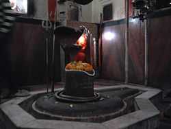
Hariharnath Mandir, Gyanpur | |
 Gyanpur Location in Uttar Pradesh, India | |
| Coordinates: 25°21′N 82°28′E / 25.35°N 82.47°ECoordinates: 25°21′N 82°28′E / 25.35°N 82.47°E | |
| Country |
|
| State | Uttar Pradesh |
| District | Sant Ravidas Nagar |
| Elevation | 81 m (266 ft) |
| Population (2001) | |
| • Total | 12,056 |
| Languages | |
| • Official | Hindi |
| Time zone | IST (UTC+5:30) |
Gyanpur is a town and a nagar panchayat in Sant Ravidas Nagar district in the Indian state of Uttar Pradesh. Current Chairman - Heeralal Maurya Current M.P - Virendra Singh
Geography
Gyanpur is located at 25°21′N 82°28′E / 25.35°N 82.47°E.[1] It has an average elevation of 81 metres (265 feet).
Demographics
As of 2001 India census,[2] Gyanpur had a population of 12,056. Males constitute 54% of the population and females 46%. Gyanpur has an average literacy rate of 86%, higher than the national average of 59.5%: male literacy is 82%, and female literacy is 87%. In Gyanpur, 15% of the population is under 6 years of age. Gyanpur stay at south side mondh station
Famous Places
- Baba Harihar Nath Temple
- Sai Dhaam
- Chakwa mahavir mandir
- Ghopaila Devi Mandir (Shri Durga Prasad Srivastava)
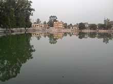
- Gyan Sarovar
- Raja Park
- Mukherjee Park
- Kashi Naresh Post Graduate Collage (K.N.P.G)
- raman hospital
- post office gyanpur
Gallery
-
Hariharnath Mandir, Gyanpur
-

Hariharnath Mandir, Gyanpur,jagannathpur,mahadevpur
References
- ↑ Falling Rain Genomics, Inc - Gyanpur
- ↑ "Census of India 2001: Data from the 2001 Census, including cities, villages and towns (Provisional)". Census Commission of India. Archived from the original on 2004-06-16. Retrieved 2008-11-01.
| ||||||||||||||||||
| ||||||||||||||||||||||||||||||||||||||||||