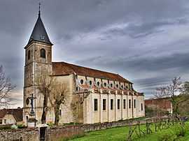
Gy, Haute-Saône
| Gy | |
|---|---|
|
Church | |
 Gy | |
|
Location within Franche-Comté region  Gy | |
| Coordinates: 47°24′25″N 5°48′47″E / 47.4069°N 5.8131°ECoordinates: 47°24′25″N 5°48′47″E / 47.4069°N 5.8131°E | |
| Country | France |
| Region | Franche-Comté |
| Department | Haute-Saône |
| Arrondissement | Vesoul |
| Canton | Gy |
| Area1 | 24.60 km2 (9.50 sq mi) |
| Population (2006)2 | 1,067 |
| • Density | 43/km2 (110/sq mi) |
| INSEE/Postal code | 70282 / 70700 |
| Elevation | 198–380 m (650–1,247 ft) |
|
1 French Land Register data, which excludes lakes, ponds, glaciers > 1 km² (0.386 sq mi or 247 acres) and river estuaries. 2 Population without double counting: residents of multiple communes (e.g., students and military personnel) only counted once. | |
Gy is a commune in the Haute-Saône department in the region of Franche-Comté in eastern France.
History
In 1389, a dispute arose over the rights to mint coins between the Duke of Burgundy, and the Archbishop of Besançon Guillaume de Vergy. The Bishop excommunicated the duke and several companions. In response, the Duke of Burgundy gave siege to the fortresses of Noroy and the castle of Gy. However, the Archbishop escaped via an underground passage, and found refuge in Avignon where he excommunicated the count of Burgundy.[1]
By 1801, the population of the town had reached 2,695, and peaked about a decade later. By 1901 it had dropped to 1,621[2] people and by 2000, only 1,034.[3]
Landmarks
- The Château de Gyrésidence des archevêques de Besançon
- Habitat vigneron et vieux bourg médiéval
- Hôtel de ville de Gy
- Église Saint-Symphorien de Gy
- Grande fontaine de Gy
- Lavoir de Gy
Notable people
- Claude-Antoine Bolot
- Luis Francisque Lélut
- Noël André (1728-1808).[4][5]
- Charles Marie Albert Travelet.[6]
-

The Château de Gy
-

The Grande fontaine de Gy
References
- ↑ Edouard Clerc, Essai sur l’histoire de la Franche-Comté, tome second, Bintot imprimeur-libraire, Besançon, 1846, p.221.
- ↑ Des villages de Cassini aux communes d'aujourd'hui.
- ↑ Fiches Insee - Populations légales de la commune pour les années.
- ↑ Louis Suchaux Galerie biographique du département de la Haute-Saône, Volume 1, 1864.
- ↑ http://www.atlascoelestis.com/ChryN%2002.htm
- ↑ Acte de décès numéro 40 du registre des décès de la commune de Gy pour l'année 1885.
See also
References
- INSEE (English)
| Wikimedia Commons has media related to Gy (Haute-Saône). |
