Gwinear–Gwithian
Coordinates: 50°13′N 5°23′W / 50.217°N 5.383°W
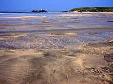
Gwinear–Gwithian (Cornish: Sen Gwynnyer–Sen Goedhyan) is a coastal civil parish in west Cornwall, England, United Kingdom. It includes the villages of Connor Downs, Gwinear, Gwithian, Reawla and Rosewarne. The parish is situated approximately two miles (3 km) east of Hayle two miles (3 km) west of Camborne.[1]
For the purposes of local government Gwinear–Gwithian has a parish council and elects councillors every four years. The principal local authority is Cornwall Council. The population of the parish was 3032 in the 2001 census.[2] This increased to 3,177 at the 2011 census[3] An electoral ward also exists with St. Erth added to the name. The population here in 2011 was 4,642.[4]
Notable buildings in Gwinear
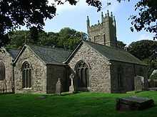
The parish church of St Gwinear is of the 13th and 14th centuries (tower mid 15th century, built of granite in three stages). There are three aisles: the south aisle which is shorter than the nave, an inner north aisle, and further north the Arundell Aisle. Lanyon Farm and Polkinghorne Farm (both less than a mile from Gwinear Road Station) are both of the 17th century.[5]
Language
Gwinear was surveyed for the Survey of English Dialects.
References
| Wikimedia Commons has media related to Gwinear–Gwithian. |
- ↑ Ordnance Survey: Landranger map sheet 203 Land's End ISBN 978-0-319-23148-7
- ↑ 2001 UK census
- ↑ "Combined civil parish population 2011 census". Retrieved 6 February 2015.
- ↑ "Electoral ward population census 2011". Retrieved 6 February 2015.
- ↑ Pevsner, N. (1970) Cornwall, 2nd ed. Penguin Books; pp. 78-79
| ||||||||||||||||||||||||||
| ||||||||||||||||||