Gwangju
| Gwangju 광주시 | |||
|---|---|---|---|
| Metropolitan City | |||
| Gwangju Metropolitan City | |||
| transcription(s) | |||
| • Hangul | 광주광역시 | ||
| • Hanja | 光州廣域市 | ||
| • Revised Romanization | Gwangju-gwangyeoksi | ||
| • McCune-Reischauer | Kwangju-kwangyŏksi | ||
|
Downtown Gwangju from city hall | |||
| |||
 Map of South Korea with Gwangju highlighted | |||
| Country |
| ||
| Region | Honam | ||
| Districts | 5 | ||
| Government | |||
| • Mayor | Yoon Jang-hyun | ||
| Area | |||
| • Total | 501.24 km2 (193.53 sq mi) | ||
| Population (October, 2014[1]) | |||
| • Total | 1,477,780 | ||
| • Density | 2,900/km2 (7,600/sq mi) | ||
| • Dialect | Jeolla | ||
| Flower | Royal Azalea | ||
| Tree | Ginkgo | ||
| Bird | Dove | ||
| GDP | US$ 36.7 billion [2] | ||
| GDP per capita | US$ 24,520 [2] | ||
| Website | gjcity.go.kr | ||


Gwangju (Korean pronunciation: [kwaŋdʑu]) is the sixth largest city in South Korea. It is a designated metropolitan city under the direct control of the central government's Home Minister. The city was also the capital of South Jeolla Province until the provincial office moved to the southern village of Namak in Muan County in 2005.
Gwang (광, Chinese letter: 光) means "light" and Ju (주, Chinese letter: 州) means "province." Areas of exquisite scenery along the outskirts of the city gave birth to gasa, a form of Korean classical poetry. Located in the center of the agricultural Jeolla region, the city is also famous for its rich and diverse cuisine.
History
The city was established in 57 BC, and has been a major political and economic centre of Korea ever since. It was one of the administrative centres of Baekje during the Three Kingdoms Period.
In 1929, during the period of Japanese rule, a confrontation between Korean and Japanese students in the city turned into a regional demonstration, which culminated in one of the major nationwide uprisings against Japanese rule during the colonial period.
Modern industry was established in Gwangju with the construction of a railway to Seoul. Some of the industries that took hold include cotton textiles, rice mills and breweries. Construction of a designated industrial zone in 1967 encouraged marked growth in industry, especially in the sectors linked to the automobile industry.
In May 1980, peaceful demonstrations took place in Gwangju against the newly installed military government of Chun Doo-hwan. The demonstrations were brutally suppressed by military forces, including elite units of the Special Operations Command. The situation escalated after a violent crackdown, resulting in the Gwangju Uprising, where the civilians raided armories and armed themselves. By the time that the uprising was suppressed, many hundred civilians and a few policemen / soldiers were dead. After civilian rule was reinstated, a national cemetery was established honouring the victims of the incident.
In 1986, Gwangju separated from Jeollanam-do to become a Directly Governed City (Jikhalsi), and then became a Metropolitan City (Gwangyeoksi) in 1995.
Gwangju is the main campaign capital of the liberal Democratic United Party, and its predecessors.
Administrative divisions
Gwangju is divided into 5 districts ("Gu").
| Map | Name | Korean | Chinese | |
|---|---|---|---|---|
| Districts | ||||
| Buk District | 북구 | 北區 | ||
| Dong District | 동구 | 東區 | ||
| Gwangsan District | 광산구 | 光山區 | ||
| Nam District | 남구 | 南區 | ||
| Seo District | 서구 | 西區 | ||

Religion
Religion in Gwangju (2005)[3]
According to the census of 2005, of the people of Gwangju 32.7% follow Christianity (19.7% Protestantism and 13% Catholicism) and 14.4% follow Buddhism.[3] 52.9% of the population is mostly not religious or follow Muism and other indigenous religions.
Population
The population model of Gwangju[4]
| Year | Population | |
|---|---|---|
| 1960 | 409,283 | |
| 1966 | 532,235 | |
| 1970 | 622,755 | |
| 1975 | 737,283 | |
| 1980 | 856,545 | |
| 1985 | 1,042,508 | |
| 1990 | 1,139,003 | |
| 1995 | 1,257,636 | |
| 2000 | 1,352,797 | |
| 2005 | 1,417,716 | |
| 2010 | 1,475,745 |
Climate
| Climate data for Gwangju (1981–2010) | |||||||||||||
|---|---|---|---|---|---|---|---|---|---|---|---|---|---|
| Month | Jan | Feb | Mar | Apr | May | Jun | Jul | Aug | Sep | Oct | Nov | Dec | Year |
| Average high °C (°F) | 5.3 (41.5) |
7.8 (46) |
13.0 (55.4) |
19.6 (67.3) |
24.3 (75.7) |
27.5 (81.5) |
29.6 (85.3) |
30.7 (87.3) |
26.9 (80.4) |
21.8 (71.2) |
14.6 (58.3) |
8.1 (46.6) |
19.1 (66.4) |
| Daily mean °C (°F) | 0.6 (33.1) |
2.5 (36.5) |
7.0 (44.6) |
13.2 (55.8) |
18.3 (64.9) |
22.4 (72.3) |
25.6 (78.1) |
26.2 (79.2) |
21.9 (71.4) |
15.8 (60.4) |
9.1 (48.4) |
3.1 (37.6) |
13.8 (56.8) |
| Average low °C (°F) | −3.1 (26.4) |
−1.8 (28.8) |
2.1 (35.8) |
7.5 (45.5) |
13.0 (55.4) |
18.2 (64.8) |
22.5 (72.5) |
22.8 (73) |
17.8 (64) |
10.9 (51.6) |
4.5 (40.1) |
−0.9 (30.4) |
9.5 (49.1) |
| Average precipitation mm (inches) | 37.1 (1.461) |
47.9 (1.886) |
60.8 (2.394) |
80.7 (3.177) |
96.6 (3.803) |
181.5 (7.146) |
308.9 (12.161) |
297.8 (11.724) |
150.5 (5.925) |
46.8 (1.843) |
48.8 (1.921) |
33.5 (1.319) |
1,391 (54.764) |
| Avg. precipitation days (≥ 0.1 mm) | 11.0 | 9.0 | 9.5 | 8.9 | 9.3 | 10.7 | 15.5 | 14.9 | 9.8 | 6.8 | 9.0 | 10.0 | 124.4 |
| Average relative humidity (%) | 67.7 | 65.2 | 62.9 | 61.9 | 66.4 | 72.8 | 80.0 | 78.1 | 74.3 | 68.4 | 68.1 | 68.8 | 69.5 |
| Mean monthly sunshine hours | 159.9 | 164.6 | 192.0 | 213.0 | 222.8 | 169.2 | 145.4 | 172.6 | 172.3 | 205.2 | 163.6 | 155.9 | 2,136.3 |
| Source: Korea Meteorological Administration[5] | |||||||||||||
Education
Chonnam National University is a public university in Gwangju.
Honam Univ, Gwangju University, Gwangshin University, Gwangju Institute of Science and Technology, Gwangju Education University, Gwangju Women's University, Nambu University, Chosun University, and Honam Christian University are private universities.
Gwangju Health College is a private community college.
The hometown of numerous renowned scholars, Gwangju has 593 schools, consisting of 234 kindergartens, 145 elementary schools, 84 middle schools, 65 high schools, 7 junior colleges, 9 universities, 38 graduate schools, and 11 others (as of 1 May 2009) with a total of 406,669 students, or 28.5% of the total city population. The average number of students per household (0.8) reflects the city's characteristic as the home of education.
Transportation
The city is served by the Gwangju Subway. An extension was completed in April 2008 with another due for completion in 2012. There are two KTX (high-speed rail) stations in the city: Gwangju Station and Songjeong-ri Station. Songjeong-ri is connected to Gwangju Subway; however, no connection exists to Gwangju Station.
It is also served by the Gwangju Airport.
Tourism
- Asian Culture Complex Information Center – As of October 2010, the Asian Culture Complex is under construction and is due to open in 2014. The Asian Culture Complex Information Center is in operation.More about Asian Culture Complex Information Center
- Gwangju Biennale – It is an internationally renowned modern art festival that is held every two years. It was first launched in 1995. The Gwangju Biennale Exhibition Hall is located at the Jung-oe Park Culture Center and the Science Center.
- Gwangju Culture & Art Center – The Center regularly hosts events.Gwangju Culture & Art Center Official Website
- Gwangju Hyanggyo (Confucian School) – Gwangju Hyanggyo is located in the Gwangju Park in Sa-dong. There are many traditional houses here estimated as built during the 1st year of the Joseon Dynasty in 1392. This is a precious national asset as this school continues to hold memorial ceremonies for Confucius twice a year. Admission is free. More about Gwangju Hyanggyo
- Gwangju National Museum – The museum houses a permanent collection of historical art and cultural relics that date back to the old Joseon and Goryeo periods of Korean history. The museum also organizes various special exhibitions and cultural learning activities that are open to all.
- Gwangju 5.18Road – 5.18 Road is the course about the Democratisation Movement in 1980. The courses include the historical places. Anyone can apply for this program and choose the course. More about 5.18Road
Culture
- 2002 FIFA World Cup – Gwangju World Cup Stadium was one of the venues used for the World Cup, and was where the South Korea national football team advanced to the semi-finals for the first time in its history, by defeating Spain.
- It is the home of KIA Tigers of the Korea Professional Baseball League (KBO)
- It is the home of Gwangju FC of the Korea Professional Soccer League (K-League)[6]
- Universiade – It will be the venue for the 2015 Summer Universiade games.
- The 3rd Asia Song Festival, organised by Korea Foundation for International Culture Exchange, in 2006, was held at the Gwangju World Cup Stadium.[7]
- The International Design Alliance (IDA) appointed Gwangju as the host destination of the 2015 IDA Congress.
- Festivals A large variety of festivals are held in Gwangju (ko:광주광역시의 축제 목록)
- 2014 Gwangju ACE Fair (Asia Content & Entertainment Fair) [8]
Sports

Gwangju is home to a K-League team, Gwangju FC, and a Korea Baseball Championship team, the Kia Tigers.
Gwangju is the host city of the 2015 Summer Universiade.
Cityscape
-
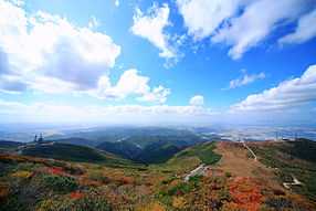
Mudeungsan
- Mudeungsan – It is the Mountain which has been the symbol of Gwangju and recently It became the national park
International relations
Twin towns – Sister cities
Partnerships and Cooperations
Other forms of partnership and city friendship similar to the twin city programmes exist:
See also
- About Gwangju
- Gwangju massacre
- General lists
- List of Korea-related topics
- List of cities in South Korea
| Wikimedia Commons has media related to Gwangju. |
References
- ↑
- ↑ 2.0 2.1 "Global city GDP 2014". Brookings Institution. Retrieved 18 November 2014.
- ↑ 3.0 3.1 2005 Census - Religion Results
- ↑ National Statistical Office of South Korea
- ↑ "평년값자료(1981–2010) 광주(156)". Korea Meteorological Administration. Retrieved 2011-05-28.
- ↑ (Korean) K-League news 4강 역사를 쓴 그곳, 광주 월드컵 경기장 Dream stadium of K-League
- ↑ KOFICE 3rd Asia Song Festival 22 September 2006. Retrieved 2011-10-12
- ↑ 2014 Gwangju ACE Fair. 2014광주ACE Fair http://www.acefair.or.kr/. Missing or empty
|title=(help) - ↑ Gwangju Sister Cities
- ↑ 姊妹市暨友誼市. Tainan City Government (in Chinese). Archived from the original on 2013-07-01. Retrieved 2013-08-01.
- ↑ Sister Cities Program. Sainternationalrelations.org. Retrieved on 2011-12-11.
- ↑ "Guangzhou Sister Cities[via WaybackMachine.com]". Guangzhou Foreign Affairs Office. Archived from the original on 24 October 2012. Retrieved 2013-07-21.
- ↑ http://www.pemkomedan.go.id/news_detail.php?id=106 MEDAN MENJALIN HUBUNGAN KOTA KEMBAR KEEMPAT Retrieved September 10, 2013 Archived 23 April 2007
- ↑ Pessotto, Lorenzo. "International Affairs - Twinnings and Agreements". International Affairs Service in cooperation with Servizio Telematico Pubblico. City of Torino. Archived from the original on 2013-06-18. Retrieved 2013-08-06.
External links
- Official website of Gwangju
- Gwangju News Online: the latest news and views about life around town
- The 18 May Memorial Foundation
- Gwangju :Official Site of Korea Tourism Org
- Gwangju International Center
- Gwangju Guidebook
- Gwangju Foreign Network – Radio Station in English for Gwangju
- Local events guide for Gwangju
| ||||||||||||||||||||||||||||||
| ||||||||||||||||||||||||||||||||||