Gwaldam
| Gwaldam | |
|---|---|
| Town | |
 Gwaldam Location in Uttarakhand, India | |
| Coordinates: 30°01′N 79°34′E / 30.02°N 79.57°ECoordinates: 30°01′N 79°34′E / 30.02°N 79.57°E | |
| Country |
|
| State | Uttarakhand |
| District | Chamoli |
| Elevation | 1,940 m (6,360 ft) |
| Languages | |
| • Official | Hindi |
| Time zone | IST (UTC+5:30) |
Gwaldam is a hill station in India, situated between the Garhwal and Kumaon. 39 km from Kausani.
Geography
Gwaldam is located at 30°01′N 79°34′E / 30.02°N 79.57°E.[1] It has an average elevation of 1,940 metres (6,364 feet). It is 20 km far from Baijnath, capital of medieval Katyuri kings and 25 km far from Kulsari the famous camp station of Nanda Devi Raj Jat and home town of Travel Friend's author and SEO by profession, Karan Rawat.[2] Karan Rawat is also the co-founder Magxp.[3]
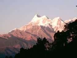
Gwaldam is a small town itself, the main reason for its prosperity is its being a junction of Kumaon and Garhwal and too many paths lead to different areas and villages. It is also a base camp for the trekkers who enter from Kathgodam (Nainital) railhead on trekking route to Lord Curzon Trail (Kuari Pass), Nanda Devi Raj Jat and Roopkund.Once it was a mandi for potato and apple trade. The view of Trishul is magnificent from here. The deodar cover of the landscape makes it a scenic spot.Here so many picnic and devotional spot are available like Badhangari, Gwaldam naag, Angyari mahadev, Machchi taal, Budhdha temple, river sites of Pindar, wildlife rich area along the Roopkund road and so on.Main village of Atal Adarsh Gram Gwaldam is talla Gwaldam which is situated 2 kilometer from Gwaldam market that was famous for ancient Dak-khana (post office) and Chaykhana (tea factory).Here one suspicious box near to the village is still the center of attraction which is placed here since British period. All these make it a tourist spot. History: Historically Gwaldam is a part of Garhwal hills and situated at the crucial borderline between Garhwal and Kumaon. Too many battles were fought here in past. It being on a strategic point it remained an apple of discord between the Garhwal and Kumaon kings.Gwaldam is situated at the saddle of Gwaldam-Shisakhani ridge and Gwaldam-Badhangarhi ridge. Border could be crossed through Gwaldam only. South of these ridges is Kumaon and north is Garhwal.Later Katyuri kings, who hailed from Joshimuth,and had sympathy for King of Garhwal because of lineage. King of Badhangarhi was under king of Garhwal and had not in good term with King of Kumaon but had good relation with Katyuri king because of neighborhoods. All these led to an unfortunate situation between Kumaon and Garhwal kings. In order to browbeat king of Badhangarhi in last decade of 16th century, Chand king sent Parkhu, a great warrior to fight with king of Badhangarhi. Unfortunately, line of supply was cut short by the Katyuri king and Parkhu was beheaded at Binayakdhar, perhaps nearby crossroad at Gwaldam. King of Garhwal rewarded the soldier who brought the head to Shrinagar. This infuriated the Chand King, Rudra Chand and he personally led the troops and captured the Katyuri king and later killed the Katyuri king Sukhal Deo and exiled his family. Thus the importance of Gwaldam can be understood. Atkinson, in his masterpiece, The Himalyan Gazzeteer, narrated all these episodes.
Because of strategic importance a base camp of ITBP was established in 1960’s and SSB training center was established in 1970’s which was meant for some secret military operation. Locally, then it was known as secret service bureau. SSB imparted guerilla warfare training.In Uttarakhand a large number of SSB guerilla trained persons are still ready to serve for any cause. At present a small unit of SSB is present at Gwaldam that runs occasional training courses. Major activities are shifted some elsewhere. Training grounds, sports fields, stadium, helipads and other infra-structure facility are still here. Local people expect that this large chunk of land, about 10 square kilometer could be used as adventure sports university or other fruitful activity. A hydro-electric power project of 252 MW is under construction. Head of this project is at Nandkesari on the river Pindar, a tributary of Holy river Ganga. By the completion of this project a beautiful lake would come up and would attract tourists from distant part of world.
Central School, Government Inter College, Girls Junior high School,Vidya-Mandir, Shishu-Mandir and other study, coaching centers are here. Krishi-Vigyan Kendra, Animal Husbandry, Vat nary Center, Fruit Processing Center, Forest Rest House, GMVN Tourist Rest House, State Bank, Chamoli District Cooperative bank branch etc., are also available here. For basic health care a government allopathic hospital is also available here. Government Degree College Talwari is situated at a distance of 11 km. from here. A State Bank of India ATM is located in the main market. Several hotels and guesthouses are available most are between 200-2000 rupees per night. A beautiful lake in FRH campus is also here with its natural beauty and dancing fishes. Civil Society Gwaldam and NEEDS are social welfare associations that are active here.
References
- The Himalayan Gazetteer by E.T. Atkinson (Author)
5. http://chamoli.nic.in/pages/display/79-gwaldam 6. http://www.pathikworld.com/cms/tag/badhangarhi-fort/