Gutu
| Gutu | |
|---|---|
| District | |
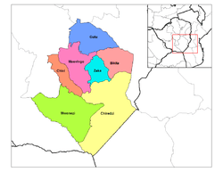 Districts of Masvingo Province | |
 Masvingo constituency seats for the 2008, showing the division of Chivi (District) | |
| Country | Zimbabwe |
| Province | Masvingo |
| District | Gutu |
| Established | late 19th century |
| Population (2002) | |
| • Total | 198 000 |
| • Density | 22.08/km2 (57.2/sq mi) |
| estimate (UN) | |
| Time zone | CET (UTC+1) |
| • Summer (DST) | CEST (UTC+1) |
Gutu is the third largest district in Masvingo Province, southern Zimbabwe, after Chiredzi and Mwenezi. It is the northernmost district in the province. The name "Gutu" is historically reported to have emerged from "Chinomukutu wemiseve" – meaning, "the one with a load of arrows". This is according to oral historical folklore of the "Gumbo" clan who are said to have taken over the area from the "Shiri" clan through killing them by poisoning the fruit trees in the "Gona" area. Mupandawana is the largest district service centre. It was designated as a "growth point" during the early years of independent Zimbabwe together with such places as Gokwe in the Midlands Province and Juru in Mashonaland East province. Mpandawana gained town status in April 2014.
It was home to the late Dr Oliver Munyaradzi, Simon Muzenda, former vice president of Zimbabwe as well as Lt. Gen. (Rtd.) Vitalis Zvinavashe (born September 27, 1943 in Gutu – died March 11, 2009) who was a Commander of the Zimbabwe Defence Forces and politician. The late Air Vice Marshal Josiah Tungamirai (8 October 1948 – 25 August 2005 was also a native of Gutu. Gutu Mission Hospital found in the district, is one of a numbers of center for HIV/AIDS treatment in the province.[1] The population is mostly the Karanga, a Shona sub-tribe. It is one of a few districts in the province where the standard of living is above average. Gutu Rural District council is in charge of the day-to-day running of the district.
Geography
Climatically, the area falls under Natural Region III. Natural Regions (NRs) in Zimbabwe's context are areas delineated on the basis of soil type, rainfall and other climatic factors.[2] It is one of a few districts in the country that suffers from over-population. Its population density of 22.08 per square kilometer is among the highest in the country.[3] Gutu district center had a population of 10-12000 in 1989. Like other districts in the country, medical facilities in the district suffer from shortage of manpower.[4]
Mpandawana Growth Point, a famous business center in Zimbabwe, is found in the district.[5] The road that connects Chivhu and Chiredzi makes the transport network to Harare quite viable
Government and politics
General elections 2008
The district was divided into four parts by the electoral commission for the general elections of 2008. Candidates from both the MDC and ZANU-PF and independents will compete for the four constituency seats available and winner will go one to represent the district in Zimbabwe's new House of Assembly.
Matuke Lovemore (Zanu-PF), and Chirume Oliver (MDC Tsvangirai) will contest the Gutu central seat while in Gutu east, Chikwama Bertha (Zanu-PF), Revai Tichaona (Independent), Makamure Ramson (MDC Tsvangirai) will fight it out. In Gutu north, the candidates are Maramwidze Edmore (MDC Tsvangirai), and the late Provincial hero Machinya Frank (Zanu-PF) while Mandevu Tarirai (Zanu-PF), and Maguma Stanley (MDC Tsvangirai) are vying for the Gutu west seat.
The results came as follows
Of the five seats, four seats were won by MDC Tsvangirai, and one went to Zanu PF.
Education and Schools
Gutu district has some of Masvingo province's finest private/church boarding schools. Among these schools are the following: High Schools
- Alheit Mission (Reformed church in Zimbabwe- formerly Dutch Reformed Church)
- Dewure Mission (Church of Christ)
- Gutu Mission (Reformed Church in Zimbabwe)
- Mukaro Mission(Roman Catholic)
- Mutero Mission(Roman Catholic)
- Serima Mission (Roman Catholic)
Secondary Schools
- Chatikobo secondary school
- Cheninga Secondary School
- Chesvingo Secondary School
- Chiguhune Secondary School
- Chikwerengwe Secondary School
- Chimedza Secondary School
- Chingombe Secondary School
- Chitenderano Secondary School
- Chitsa secondary school
- Dewende Secondary School
- Domborembava Secondary School
- Guni Secondary School
- Guzha Secondary School
- Hunduza Secondary School
- Machingambi Secondary School
- Magombedze secondary school
- Majada Secondary School
- Makamure Secondary School
- Makumbe Secondary School
- Makura Secondary School
- Mataruse Secondary School
- Maungwa High school
- Mpandawana Secondary School
- Muchekayaora Secondary School
- Mundondo High School
- Mundondo High School
- Munjanganja Secondary School
- Munyaradzi Secondary School
- Munyikwa Secondary School
- Mushayavanhu Secondary School
- Mutambwi Secondary School
- Nemashakwe Secondary School
- Nerupiri High School
- Nharira Secondary School
- Nyazvidzi Secondary School
- Rafomoyo Secondary School
- Rumhizha Secondary School
- Rupiri Secondary School
- Tirizi Secondary School
- Tongogara Secondary School
- Vumba Secondary School
- Zimbizi Secondary school
Primary Schools
- Bako Primary School
- Berry Spring Primary School
- Chamisa Primary School
- Chekure Primary School
- Cheninga Primary School
- Chiguhune Primary School
- Chihambakwe Primary School
- Chikara Primary school
- Chimedza Primary School
- Chesvingo Primary School
- Chidembo Primary School
- Chipangane Primary School
- Chitando Primary School
- Chitepo Primary School
- Chitsa Primary School
- Chivasa Primary School
- Dambara Primary School
- Dewure Primary School
- Gona School
- Gonese Primary school
- Gono Primary School
- Gonye Primary School
- Gorondondo Primary School
- Guni Primary School
- Gudo Primary School
- Gutu Central Primary School
- Gutu United School
- Guvamatanga Primary School
- Guzha Primary School
- Gwiranenzara Primary School
- Hamandishe Primary School
- Hwiru Primary School
- Kufonya Primary School
- Kurai Primary School
- Machingambi Primary School
- Magadzire Primary School
- Magombedze primary school
- Majada Primary School
- Makonde Primary School
- Makore Primary School
- Makumbe Primary School
- Makura Primary School
- Maregedze Primary School
- Marinda Primary School
- Masvingise Primary school
- Mataruse Primary School
- Mawere primary School
- Mauzhe Primary school
- Mondo Primary School
- Muchekayaora Primary School
- Mugodhi Primary School
- Mukaro Dutch Primary School
- Mukoroverwa Primary School
- Mukundi Primary School
- Mundondo Primary School
- Munyaradzi Primary School
- Munyikwa Primary School
- Mupata Primary School
- Mushayavanhu Primary School
- Mutambwi Primary School
- Mutema Primary School
- Mutunduru Primary School
- Mutombwa Primary School
- Ndisengei Primary School
- Nerupiri Primary School
- Rafomoyo Primary School
- Ranga Primary School
- Ruti Primary School
- Simbanegavi Primary School
- Shumbairerwa Primary School
- Soti Source Primary School
- Svazva Primary School
- Trafalgar Primary School
- Vhunjere Primary School
- Zinhata Primary School
- Zvavahera Primary School
- Chatikobo Primary School
- Nharira Primary School
- Mutanda Primary School
- Masunda Primary School
- Nyamandi Primary School
- Mutero Primary School
- Tirizi Primary School
Tertiary Colleges
- Gutu Mission School of Nursing
- Hubvumwe Training Institute
Clinics and Hospitals
- Alheit Clinic
- Chimombe
- Cheshuro Clinic
- Chin'ai Clinic
- Chinyika
- Chitando Rural Hospital
- Dambara clinic
- Denhere Clinic (Chiguhune)
- Dewure Clinic
- Gomba
- Guni/Muvunde Clinic
- Gutu Mission Hospital
- Gutu Rural General Hospital
- Kubiku Clinic
- Mbambo/Vhunjere Clinic
- Mukaro Clinic
- Mutema Clinic
- Mutero Clinic
- Nyazvidzi
- Zinhata Clinic
- Zvavahera
- Nemashakwe Clinic
Notable Families
•Mutsengi
- Bara
- Bere
- Chilimanzi/churumhanzu
- Chabata
- Chagwiza
- Chakawa / Munodawafa
- Chatikobo
- Chifamba
- Chigumbu
- Chikombingo
- Chimedza
- Chimombe
- Chimuka
- Chisveto
- Chitsa / Chitakira
- Chivasa
- Chiwara
- Chirikure
- Chiorese
- Choga
- Choto
- Dauramanzi
- Dondo
- Gonan'ombe
- Gonese
- Goronga
- Guni
- Gutu
- Hadzoi
- Hamandishe
- Jakachira
- Kubvoruno
- Kacha
- Machinya
- Madondo
- Madzana
- Madziva/Musara
- Madzore
- Magombedze
- Mahofa
- Munyoro
- Makadho/Mutema
- Makonese
- Makore
- Maleti
- Mandinyenya
- Manwa
- Manzanga
- Marimira / Mutema
- Marukutira/Gumba/Muvungani
- Maorera
- Matsongoni
- Mawire
- Mawarire
- Maharure
- Murumbi/Rwanyanya
- Masanganise
- Mashandika
- Masendeke
- Mativenga
- Mazango/Masheka
- Mazendame
- Mhuru
- Mkushi
- Muchekayaora
- Mudavanhu
- Mudzamba
- Mudzvova/Maturure/Mutema
- Mugova/Goverai *Muhenyeri
- Mukaro
- Mukondo
- Mukoroverwa
- Mukushi
- Munyaradzi
- Ushendibaba
- Makura
- Zivambiso
- Mashinge
- Machote
- Munyikwa
- Murombo
- Musara
- Musiiwa
- Nerupiri
- Musendo/Mugiyo
- Mushambi
- Musina/Chibodo/Muzenda
- Mutambara
- Mhokore
- Muderedzwa
- Munodawafa
- Mutando
- Mutema (Chieftainship)
- Muvungani/Muungani
- Mutika
- Muzenda
- Ndawi
- Ndisengei
- Ngwaru
- Nhambure/Mtuketsa
- Rafomoyo
- Runyowa
- Runzonza
- Rushwaya
- Chizema
- Mudhawu
- Rutsate
- Sadzauchi
- Shumbairerwa
- Tagutanazvo
- Tavagadza/Mberikunashe
- Tawonezvi
- Tsvangirai
- Zinhata
- Zirebwa
- Zvarevashe
- Zvenyika/samaita's
- Zvinavashe
- Mashonganyika/Machena
- Sikhala
- Basopo
- Pugede Madanyaya
- Makanyire
- Sengai
- Chindito
- Mudhodhoma
- Themba
- Mapanzure
- Rwafa
- Mashora
- Ushe
- Boora
- Mbwende/Tavarwisa
- Maburutse
- Makumbe
- Nyemba
- Mutimhodyo
Notable Persons/Residents
- Paul Tangi Mhova Mkondo, Nationalist, Indigenous Businessman, Insurance & Property Guru
- Mr Ticharwa Madondo(Politician&Businessman)
- Elisha Tavagadza Mberikunashe,Banker
- Simon Vengai Muzenda (late Vice President of Zimbabwe)
- Air Vice Marshal Josiah Tungamirayi
- Oliver Munyaradzi
- General Vitalis Gava Zvinavashe
- Norman Muzhinji ( Biotechnologist)
- Edmond Masanganise (Paramount Chief Gutu)
- Senator Obert Gutu (Lawyer & Senator)
- Mr Tipson Maleti(Academia, ICT Consultant, ICT Specialist)
- Mr Chikombingo Clemence (Technologist, Academia)
- Jethro Dauramanzi (Business man)
- Professor Mukonoweshuro (late, MDC MP for Gutu North & Minister)
- Professor Heneri Dzinotyiweyi (Mathematician, academic & Minister)
- Professor Davison Munodawafa (Public Health - WHO, UN)
- Shuvai Mahofa (ex-MP for Gutu South)
- The late Mr E.D.Madondo (Prominent Gutu Business man)
- Job Sikhala (Founder member of the original MDC, former MP for St Marys and now President for MDC 99)
- Moses Marukutira Muvungani (Politician and Human rights activist)
- Nelson Chamisa, politician
- Wurayayi Zembe (Politician, human rights activist and academic)
- Juta Dhauramanzi (Fitter and Turner)
- Tracey Munodawafa (Teacher-BCom, MBA)
- Daniel Musina (IT Consultant)
- Dominic Musina (Med, Bed (UZ))
- Martha Musina-Munyaradzi (Business Woman - Gutu)
- George Chibodo (Electrician)
- Tadios Munodawafa (IT Educationist, BSc Computing & Statistics-UZ)
- McDonald Muzenda (Health)
- Muzenda Francis Muzenda (IT)
- Davison Zimwara (Bsc, Msc Mechanical Eng (UZ))
- Dickson Zivambiso (Academic,IT,CCA)
- Ndiripo George Simbi (Businessman and Politician)
- Raymond Zvoushe Bhoroma/Chindito/Muzenda (Chartered Accountant)
- Shadreck Musendo (Security Specialist-IT)
- Sam Mawire (Internal Auditor/Political Activist)
- Menard Zvenyika(Revrend,Priest-RCZ,Pamushana mission)
- Ceaphas Rock Zvenyika(IT Consultant)
- Anderson Maregedze
- Tapiwa Terrence Munodawafa (IT Specialist)
- Vakai Muradzikwa (MSc, IT Specialist)
- The late Moses Mutadzi Gandiwa Manwa- Teacher and Master Farmer in Nyazwidzi purchase area.
- Phinias Manwa-Pharmaceutical Production Executive (EU) & Modern Farmer in Nyazvidzi
- Moreblessings Chatindo (Power Electrician)
- Mashukushe Christopher (QS) and Entrepreneur
- Oliver Tavengwa Munodawafa (Carpenter and Entreprenaur)
- Denhere Gonese (Ford Master Technician)
- Rodreck Mutimhodyo ( Electronic technician)
- Cryton Munyikwa (Accountant)
- Reverend Charles Juro (General secretary RCZ SYNOD)
References
- ↑ AIDS treatment centers (accessed 18 February 2008)
- ↑ CSO, 1997, 144
- ↑ Land Use in Gutu
- ↑ Zimbabwe Brain Drain (accessed 18 February 2008)
- ↑ Gutu RDC offered 1billion (accessed 18 February 2008)
Coordinates: 19°39′S 31°10′E / 19.650°S 31.167°E
| ||||||||||||||||||
| ||||||||||||||||||