Gunnerside

Coordinates: 54°22′44″N 2°04′34″W / 54.379°N 2.076°W
Gunnerside is a village in the Richmondshire district of North Yorkshire, England. It is situated on the B6270 road, and approximately 25 miles (40 km) west of the county town of Northallerton. The village lies between the River Swale and its tributary, Gunnerside Beck, in the Swaledale part of the Yorkshire Dales National Park.
Gunnerside Ghyll (or Gunnerside Gill), a smaller valley running northwards, at right angles to the Swale valley (Swaledale), was the site of a major lead mining industry in Swaledale until the late nineteenth century.
Gunnerside contains a Methodist Chapel, a part-time post office, and a working smithy/museum. The village primary school is one of two sites of the Reeth and Gunnerside Schools. At the foot of Gunnerside Ghyll is the Kings Head public house. At the south of the village is the Grade II listed 1830s Gunnerside New Bridge over the River Swale.[1]
Local employment centres on clockmaking, hill farming, gamekeeping and construction, the latter concerned chiefly with the maintenance of traditional stone-built field walls, houses and barns.
-
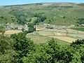
Looking north to Gunnerside
-
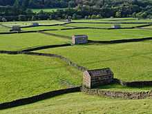
Stone barns in the meadows near Gunnerside New Bridge
-
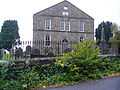
Methodist Church
References
- ↑ Historic England. "Gunnerside New Bridge (Grade II) (1179749)". National Heritage List for England. Retrieved 3 January 2014.
External links
![]() Media related to Gunnerside at Wikimedia Commons
Media related to Gunnerside at Wikimedia Commons
- Gunnerside.info
- Gunnerside Gill and Swinner Gill Walk (web archive)
- Gunnerside burial records
- Gunnerside school
See also
- Operation Gunnerside, which may have got its name because the participants trained near Gunnerside.