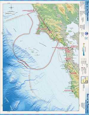
Gulf of the Farallones National Marine Sanctuary
The Gulf of the Farallones National Marine Sanctuary is one of 13 marine sanctuaries in the U.S., found outside San Francisco's Golden Gate surrounding the Gulf of the Farallones
History
It comprises part of the United Nations' Golden Gate Biosphere Reserve. It adjoins two other National Marine Sanctuaries, Monterey Bay National Marine Sanctuary and Cordell Bank National Marine Sanctuary. The Sanctuary was declared in 1981 and protects about 1,250 square miles (3,237 km2) of the waters off San Francisco, part of the highly productive California Current System. Within the sanctuary are the Farallon Islands and associated National Wildlife Refuge, the sanctuary protects the feeding grounds of the seabirds and seals that breed and haul out on the islands. The sanctuary also protects migrating whales, especially gray whales, and a population of great white sharks.
Expansion
In 2012, the National Oceanic and Atmospheric Administration proposed an expansion of the borders of the sanctuary, along with expansion of the Cordell Bank National Marine Sanctuary, to include an additional 2,700 square miles, reaching to Point Arena.[1] Expansion was passed March 2015.[2]
See also
References
External links
Further reading
- Beyond the Golden Gate: Oceanography, Oceanography, Geology, Biology, and Environmental Issues in the Gulf of the Farallones. (2000). Edited by Herman A. Karl, John L. Chin, Edward Ueber, Peter H. Stauffer, and James W. Hendley II. U.S. Geological Survey, Circular 1198. Online at .
|
|---|
| | |
|---|
| | National Parks | |
|---|
| | National Preserves | |
|---|
| | National Monuments | |
|---|
| | National Seashores | |
|---|
| | National Historical Parks | |
|---|
| | National Historic Sites | |
|---|
| | National Memorials |
- Port Chicago Naval Magazine
|
|---|
| | National Recreation Areas | |
|---|
|
| | | |
|---|
| | State Parks | |
|---|
| | State Natural Reserves | |
|---|
| | State Marine Reserves | |
|---|
| | State Historic Parks | |
|---|
| | State Beaches | |
|---|
| | State Recreation Areas | |
|---|
| | State Vehicular Recreation Areas |
- Carnegie
- Clay Pit
- Heber Dunes
- Hollister Hills
- Hungry Valley
- Oceano Dunes
- Ocotillo Wells
- Prairie City
|
|---|
| | Other | |
|---|
|
| | | |
|---|
| | National Forests and Grasslands | |
|---|
| National Wilderness
Preservation System | |
|---|
| | Other | |
|---|
|
| | | | | | | State Wildlife Areas |
|---|
| | Wildlife Areas | |
|---|
| | Ecological Reserves |
- Albany Mudflats
- Alkali Sink
- Allensworth
- Atascadero Creek Marsh
- Bair Island
- Baldwin Lake
- Batiquitos Lagoon
- Blue Sky
- Boden Canyon
- Boggs Lake
- Bolsa Chica
- Bonny Doon
- Buena Vista Lagoon
- Butler Slough
- Butte Creek Canyon
- Butte Creek House
- Buttonwillow
- By Day Creek
- Calhoun Cut
- Canebrake
- Carlsbad Highlands
- Carmel Bay
- Carrizo Canyon
- Carrizo Plains
- China Point
- Clover Creek
- Coachella Valley
- Coal Canyon
- Corte Madera Marsh
- Crestridge
- Dairy Mart Ponds
- Dales Lake
- Del Mar Landing
- Eden Landing
- Elkhorn Slough
- Estelle Mountain
- Fall River Mills
- Fish Slough
- Fremont Valley
- Goleta Slough
- Indian Joe Spring
- Kaweah
- Kerman
- King Clone
- Laguna Laurel
- Loch Lomond Vernal Pool
- Lokern
- Magnesia Spring
- Marin Islands
- Mattole River
- McGinty Mountain
- Morro Dunes
- Morro Rock
- Napa River
- North Table Mountain
- Oasis Spring
- Panoche Hills
- Peytonia Slough
- Pine Hill
- Piute Creek
- Pleasant Valley
- Point Lobos
- Rancho Jamul
- Redwood Shores
- River Springs Lakes
- Saline Valley
- San Dieguito Lagoon
- San Elijo Lagoon
- San Felipe Creek
- San Joaquin River
- Santa Rosa Plateau
- Springville
- Stone Corral
- Sycamore Canyon
- Sycuan Peak
- Thomes Creek
- Tomales Bay
- Upper Newport Bay
- Watsonville Slough
- West Mojave Desert
- Woodbridge
- Yaudanchi
|
|---|
| | Marine Protected Areas | |
|---|
|
| | | |
|---|
| | National Monuments | |
|---|
| | National Conservation Areas | |
|---|
| | Wilderness Areas | |
|---|
|
| | | | | | | |
|---|
|
- Año Nuevo Island
- Bodega Marine
- Box Springs
- Boyd Deep Canyon Desert Research Center
- Burns Piñon Ridge
- Carpinteria Salt Marsh
- Chickering American River
- Coal Oil Point
- Dawson Los Monos Canyon
- Eagle Lake Field Station
- Elliott Chaparral
- Emerson Oaks
- Fort Ord
- Hastings
- James San Jacinto Mountains
- Jenny Pygmy Forest
- Jepson Prairie
- Kendall-Frost Mission Bay Marsh
- Kenneth S. Norris Rancho Marino
- Landels-Hill Big Creek
- McLaughlin
- Motte Rimrock
- Quail Ridge
- Sagehen Creek Field Station
- San Joaquin Freshwater Marsh
- Santa Cruz Island
- Scripps Coastal
- Sedgwick
- Stebbins Cold Canyon
- Steele Burnand Anza-Borrego
- Stunt Ranch Santa Monica Mountains
- Sweeney Granite Mountains Desert Research Center
- Valentine Eastern Sierra
- Younger Lagoon
|
| | |
|
