Guilmécourt
| Guilmécourt | |
|---|---|
 Guilmécourt | |
|
Location within Upper Normandy region  Guilmécourt | |
| Coordinates: 49°58′02″N 1°18′11″E / 49.9672°N 1.3031°ECoordinates: 49°58′02″N 1°18′11″E / 49.9672°N 1.3031°E | |
| Country | France |
| Region | Upper Normandy |
| Department | Seine-Maritime |
| Arrondissement | Dieppe |
| Canton | Envermeu |
| Intercommunality | Petit Caux |
| Government | |
| • Mayor | Pierre Batte |
| Area1 | 7.92 km2 (3.06 sq mi) |
| Population (2006)2 | 261 |
| • Density | 33/km2 (85/sq mi) |
| INSEE/Postal code | 76337 / 76630 |
| Elevation |
44–147 m (144–482 ft) (avg. 105 m or 344 ft) |
|
1 French Land Register data, which excludes lakes, ponds, glaciers > 1 km² (0.386 sq mi or 247 acres) and river estuaries. 2 Population without double counting: residents of multiple communes (e.g., students and military personnel) only counted once. | |
Guilmécourt is a commune in the Seine-Maritime department in the Haute-Normandie region in northern France.
Geography
A farming village situated in the Pays de Caux, some 11 miles (18 km) northeast of Dieppe at the junction of the D222, D117 and the D454 roads.
Heraldry
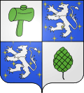 |
The arms of Guilmécourt are blazoned : Quarterly 1: argent, a mallet vert; 2&3 Azure étincelé, a lion argent; 4: argent, a pinecone vert. (étincelé is an obscure semy of 'sparks' often tiny 'stars' as here) |
Population
| Year | 1962 | 1968 | 1975 | 1982 | 1990 | 1999 | 2006 |
|---|---|---|---|---|---|---|---|
| Population | 166 | 185 | 185 | 245 | 240 | 241 | 261 |
| From the year 1962 on: No double counting—residents of multiple communes (e.g. students and military personnel) are counted only once. | |||||||
Places of interest
- The church of St.Waast, dating from the thirteenth century.
- A sixteenth-century stone cross.
- A feudal motte.
Photos from around Guilmécourt
-

Guilmécourt church
-

Guilmécourt under snow
-

A field of flax
-

Harvest time
-

Oil-seed rape fields
-

Wheatfields
-

The countryside
-

Sheep
-

The countryside
-

Guilmécourt at night
-

Flower of the flax
-

A field of cut flax
See also
- Communes of the Seine-Maritime department
- Seine-Maritime
- Normandy
References
External links
| Wikimedia Commons has media related to Guilmécourt. |
- Guilmécourt on the Quid website (French)