Guelmim-Es Semara
| Guelmim-Es Semara كلميم السمارة | |
|---|---|
| Region | |
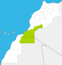
.svg.png) Location in Morocco | |
| Coordinates: 28°09′N 10°04′W / 28.150°N 10.067°WCoordinates: 28°09′N 10°04′W / 28.150°N 10.067°W | |
| Country |
|
| Capital | Guelmim |
| Government | |
| • Wali | Abdellah Amimi |
| Area | |
| • Total | 122,825 km2 (47,423 sq mi) |
| Population (2014 census) | |
| • Total | 501,921 |
| Time zone | WET (UTC+0) |
| • Summer (DST) | WEST (UTC+1) |
Guelmim-Es Semara (Arabic: كلميم السمارة) is one of the sixteen regions of Morocco. It covers an area of 122,825 km² and has a population of 501,921 (2014 census).[1]
Geography
The southern half of Guelmin-Es Semara forms part of the Western Sahara. The regional capital is Guelmim. The region is bordered to the north by Souss-Massa-Drâa and to the west by Laayoune-Boujdour-Sakia El Hamra, with the Algerian province of Tindouf to the east. Its disputed territory in the Western Sahara borders the Mauritanian Tiris Zemmour Region. Guelmin-Es Semara has a coastline on the Atlantic Ocean, with the Spanish Canary Islands lying off it. The Draa River, at 1,100 km the longest in Morocco, flows into the Ocean near Tan-Tan.
The region is made up of the following provinces:
- Assa-Zag Province
- Es Smara Province
- Guelmim Province
- Tan-Tan Province
- Tata Province
Municipalities by population (2004 census)
- Guelmin, Guelmim Province: 95,599
- Tan-Tan, Tan-Tan Province: 60,560
- Es Semara, Es Smara Province: 33,910[3]
- Tata, Tata Province: 15,192
- Bouizakarne, Guelmim Province: 11,982
- Assa, Assa-Zag Province: 11,667
- Foum Zguid, Tata Province: 9,611
- Zag, Assa-Zag Province: 7,751
- El Ouatia, Tan-Tan Province: 6,294
- Akka, Tata Province: 6,312
- Fam El Hisn, Tata Province: 6,183
References
- ↑ "Recensement général de la population et de l'habitat de 2004". Haut-commissariat au Plan, Lavieeco.com. Retrieved 22 April 2012.
- ↑ http://www.hcp.ma/Recensement-general-de-la-population-et-de-l-habitat-2004_a633.html
- ↑ Within the Western Sahara
| |||||||||||||||||
| ||||||||