Guanyin District
| Guanyin 觀音區 | |
|---|---|
| District | |
| Guanyin District | |
 | |
 | |
| Coordinates: 25°02′N 121°06′E / 25.033°N 121.100°ECoordinates: 25°02′N 121°06′E / 25.033°N 121.100°E | |
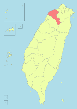
| Country |
|
| Region | Northern Taiwan |
| Government | |
| • Mayor | Ou Bingchen |
| Area | |
| • Total | 87.9807 km2 (33.9695 sq mi) |
| Population (December 2014) | |
| • Total | 63,602 |
| • Density | 720/km2 (1,900/sq mi) |
| Website | www.guanyin.gov.tw |
Guanyin District (Chinese: 觀音區; pinyin: Guānyīn Qū) is a rural, coastal district in western Taoyuan City, Taiwan. Guanyin is also the name of a god in Buddhism in Taiwan.
History
Guanyin was originally named as Shiguanyin during the Qing Dynasty rule. It was renamed to Guanyin in 1920 during the Japanese rule. On 25 December 2014, it was upgraded to a district named Guanyin District.[1]
Geography
- Area: 87.98 km²
- Population: 63,602 people (December 2014)
Guanyin is part of the alluvial fan in Taoyuan County.[2] The coastline is about 15 km at the northern side.
Administrative divisions
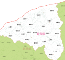
Guanyin Village, Baiyu Village, Guangxing Village, Datan Village, Baosheng Village, Wuwei Village, Sanhe Village, Xinxing Village, Kengwei Village, Jinhu Village, Lanpu Village, Datong Village, Daku Village, Lunping Village, Fuyuan Village, Shangda Village, Xinpo Village, Guangfu Village, Tajiao Village, Baozhang Village, Caota Village, Caoxin Village, Shulin Village, Fulin Village.[3]
Infrastructure
Tourist attractions
- 1213 Baosheng Inn
- Datian Lotus Farm
- Golden Lake Shore
- Kangzhuang Lotus Garden
- Lin's Old Style House
- Longman Bottle Gourd
- Lotus Garden
- Monet's Garden
- Qinglin Farm
- Sanqi Bee Park
- Sun and Green Farm
- Wu Cuo Yang Jia Zhuang
- Xianghao Leisure Farm
- Yifeng Leisure Farm
- Yuanyin Farm
- Yuxuan Garden
- Zhong's Garden
See also
| Wikimedia Commons has media related to Guanyin District, Taoyuan. |
References
- ↑ "Taoyuan County Government - Guanyin Township". Tycg.gov.tw. 2014-05-06. Retrieved 2014-05-23.
- ↑ "Topology and geography". Guanyin Township Office. Retrieved 2010-06-28.
- ↑ http://vote2014.nat.gov.tw/en/TV/nm300001300000000.html
External links
- Guanyin Township Office (Chinese)
| |||||||||||||||||