Gualtieri
| Gualtieri | |
|---|---|
| Comune | |
| Comune di Gualtieri | |
|
Watch Tower in Gualtieri. | |
 Gualtieri Location of Gualtieri in Italy | |
| Coordinates: 44°54′N 10°38′E / 44.900°N 10.633°ECoordinates: 44°54′N 10°38′E / 44.900°N 10.633°E | |
| Country | Italy |
| Region | Emilia-Romagna |
| Province | Reggio Emilia (RE) |
| Frazioni | Bigliana, Bigliardi, Canossa, Livello, Marinona, Pieve Saliceto, Reseghetta Inferiore, Santa Vittoria, Soliani, Vecchia |
| Government | |
| • Mayor | Massimiliano Maestri |
| Area | |
| • Total | 36.1 km2 (13.9 sq mi) |
| Elevation | 22 m (72 ft) |
| Population (31 May 2007)[1] | |
| • Total | 6,502 |
| • Density | 180/km2 (470/sq mi) |
| Demonym | Gualtierini |
| Time zone | CET (UTC+1) |
| • Summer (DST) | CEST (UTC+2) |
| Postal code | 42044 |
| Dialing code | 0522 |
| Patron saint | Santa Maria della Neve |
| Saint day | August 5 |
| Website | Official website |
Gualtieri is a comune (municipality) in the Province of Reggio Emilia in the Italian region Emilia-Romagna, located about 70 kilometres (43 mi) northwest of Bologna and about 25 kilometres (16 mi) north of Reggio Emilia on the right bank of the Po River. Historically, it suffered numerous flood, the last occurring in 1951.
Main sights
Gualtieri's main attraction is its Renaissance quare Piazza Bentivoglio, designed by Giovanni Battista Aleotti (also responsible of the Palazzo Bentivoglio, which was the residence of the Marquisses of Gualtieri). The latter has 17th century decorations and houses a museum dedicated to the painter Antonio Ligabue. Also facing the square is the Collegiata di S. Maria della Neve, again designed by Aleotti but remade after its destruction from a flood, which houses a Crucifixion by Camillo Ricci.
Other sights include the 13th century church of Sant'Andrea and the 16th century church Chiesa della Concezione. About 6 kilometres (4 mi) outside Gualtieri, on the road to Reggio Emilia, is the 18th century Palazzo Greppi.
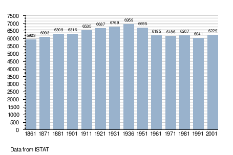
Demographic evolution
