Gros Morne National Park
| Gros Morne National Park | |
|---|---|
|
IUCN category II (national park) | |
|
The Tablelands in Gros Morne National Park | |
 Location of Gros Morne National Park | |
| Location |
|
| Nearest city | Corner Brook |
| Coordinates | 49°41′22″N 57°44′17″W / 49.68944°N 57.73806°WCoordinates: 49°41′22″N 57°44′17″W / 49.68944°N 57.73806°W |
| Area | 1,805 km2 (697 sq mi) |
| Established | 1973 |
| Governing body | Parks Canada |
| Type | Natural |
| Criteria | vii, viii |
| Designated | 1987 (11th session) |
| Reference no. | 419 |
| State Party |
|
| Region | Europe and North America |
Gros Morne National Park is a world heritage site located on the west coast of Newfoundland. At 1,805 km2 (697 sq mi), it is the second largest national park in Atlantic Canada; it is surpassed by Torngat Mountains National Park, which is 9,700 km2 (3,700 sq mi).
The park takes its name from Newfoundland's second-highest mountain peak (at 2,644 ft/806 m) located within the park. Its French meaning is "large mountain standing alone," or more literally "great sombre." Gros Morne is a member of the Long Range Mountains, an outlying range of the Appalachian Mountains, stretching the length of the island's west coast. It is the eroded remnants of a mountain range formed 1.2 billion years ago. "The park provides a rare example of the process of continental drift, where deep ocean crust and the rocks of the earth's mantle lie exposed."[1]
The Gros Morne National Park Reserve was established in 1973, and was made a national park in October 1, 2005.
The park was the subject of a short film in 2011's National Parks Project, directed by Sturla Gunnarsson and scored by Melissa Auf der Maur, Sam Shalabi and Jamie Fleming.
Geology
The park's rock formations, made famous by Robert Stevens and Harold Williams, include oceanic crust and mantle rock exposed by the obduction process of plate tectonics, as well as sedimentary rock formed during the Ordovician, Precambrian granite and Palaeozoic igneous rocks.[2]
Soils
The many soil associations mapped in the park reflect the wide variety of bedrock. The Silver Mountain soil association, dominant in the northeastern area, is a very stony sandy loam developed on glacial till overlying granite, granitic gneiss and schist. Similar rocks underlie the St. Paul's Inlet association farther west. Sedimentary rocks (including some dolomitic limestone) in the southeastern sector support the North Lake association of stony sandy loam. An association of mostly-shallow loam, the Cox's Cove, occupies a discontinuous band over shale, slate, limestone and sandstone near the coast. The coastal strip north of Bonne Bay is mostly underlain by the peaty Gull's Marsh association and the coarse Sally's Cove association except for an area of clay (Wood's Island association) around Rocky Harbour. The stony infertile soils of the ultramafic tablelands south of Bonne Bay belong to the Serpentine Range association.[3]

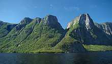
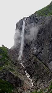
Western Brook Pond is a fresh water fjord which was carved out by glaciers during the most recent ice age from 25,000 to about 10,000 years ago. Once the glaciers melted, the land, which had been pushed down by the weight of the ice sheet, rebounded and the outlet to the sea was cut off. The 30-kilometre (19 mi) long narrow "pond" then filled in with fresh water. The water in the fjord is extremely pure and is assigned the highest purity rating available for natural bodies of water. Pissing Mare Falls, the highest waterfall in eastern North America[4] and 199th highest in the world,[5] flow into Western Brook Pond.

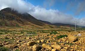
The Tablelands, found between the towns of Trout River and Woody Point in Gros Morne National Park, look more like a barren desert than traditional Newfoundland. This is due to the ultramafic rock – peridotite – which makes up the Tablelands. It is thought to originate in the Earth's mantle and was forced up from the depths during a plate collision several hundred million years ago. Peridotite lacks the usual nutrients required to sustain most plant life, hence its barren appearance. The rock is very low in calcium, very high in magnesium, and has toxic amounts of heavy metals. Peridotite is also high in iron, which accounts for its brownish colour (rusted colour). Underneath this weathered zone, the rock is really a dark green colour.
Nature and wildlife

Fauna
The most notable animal in the park is the moose, part of a booming population that was introduced to Newfoundland around 1900. Other common wildlife in the park include an ecotype of caribou (R.t caribou), black bear, red fox, snowshoe hare, red squirrel and beaver. Harbour seals are common in St. Pauls inlet, and whales may be in the area especially during the capelin season in early summer. Many bird species can be found in the park, from shorebirds along the ocean to birds of the bogs and interior forests.[6]
World Heritage Site
In 1987, the park was designated a UNESCO World Heritage Site for both its geological history and its exceptional scenery. The geology of the Park in particular illustrates the concept of plate tectonics,[7] and has shed important light on geological evolution and its processes.
Trails
Hiking the trails is a popular activity at Gros Morne. There are about 20 marked day trip trails, exploring coastal and interior areas of the park. One of the more strenuous dayhikes is the 16 km hike over Gros Morne Mountain. This trail is also called the James Callaghan Trail after the former British Prime Minister, who visited in 1976, in recognition of his conservation efforts. A small controversy arose after the Prime Minister did not visit the trail that had been named in his honour.[8]
The interior of the park can also be accessed, notably through the multi-day Long Range Traverse between Western Brook Pond and Gros Morne Mountain.
Gallery
-

Panorama over Bonne Bay
-

The Tablelands seen from Route 431
-

Along Route 430 near Rocky Cove
-

Western Brook Pond
-

S.S. Ethie day use area
-

Sea cave at the end of the Green Garden Trail beyond the Tablelands
-

Western Brook Pond, from boat
-

Pissing Mare Falls, Western Brook Pond
-
.jpg)
Interior of park on traverse from Gros Morne to Western Brook Pond
-
.jpg)
Hiking on north rim of Western Brook Pond towards the coast
-
.jpg)
A pier at Norris Point
See also
| Wikimedia Commons has media related to Gros Morne National Park. |
References
- ↑ http://whc.unesco.org/en/list/419
- ↑ A guide to the geology of the park and adjacent areas http://gac.esd.mun.ca/nl/pdf/Field%20Guide%202003.pdf
- ↑ http://sis.agr.gc.ca/cansis/publications/nf/nf11/intro.html Soils of the Sandy Lake – Bay of Islands Area, Western Newfoundland
- ↑ "World Waterfall Database: North American Falls". Retrieved 2012-02-23.
- ↑ "World Waterfall Database: World-wide Falls". Retrieved 2012-02-23.
- ↑ A place mammals can call home, 4 June 2014, retrieved 13 September 2014
- ↑ "The Story in Stone". Parks Canada.
|first1=missing|last1=in Authors list (help) - ↑ Burgess, Kaya (December 30, 2008). "The late 70s Callaghan beset by Canadian environmentalists". The Times (London). Retrieved May 4, 2010.
External links
- Gros Morne: A Cultural History
- Park web site
- Park webpage at Worldheritagesite.org
- UNESCO WHS Gros Morne National Park
- Town of Woody Point
| ||||||||||||||||||||||||||
| ||||||||||||||||||||||||||
