Groomsville, Queensland
| Groomsville Queensland | |||||||||||||
|---|---|---|---|---|---|---|---|---|---|---|---|---|---|
|
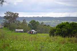
View over farmland at Groomsville looking east towards Pechey Forestry from Green Acres Road, 2015 | |||||||||||||
 Groomsville | |||||||||||||
| Coordinates | 27°21′S 151°57′E / 27.350°S 151.950°ECoordinates: 27°21′S 151°57′E / 27.350°S 151.950°E | ||||||||||||
| Population | 444 (2011)[1] | ||||||||||||
| Postcode(s) | 4352 | ||||||||||||
| LGA(s) | Toowoomba Region | ||||||||||||
| State electorate(s) | Nanango | ||||||||||||
| Federal Division(s) | |||||||||||||
| |||||||||||||
Groomsville is a locality in the Toowoomba Region local government area of the Darling Downs in southern Queensland, Australia. At the 2011 Australian Cenus Groomsville and surrounds recorded a population of 444.[1] The area remains undeveloped.
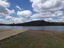
Cooby Dam, 2014
Part of the eastern and southwest boundary is marked by Cooby Creek. The creek flows in to and out of Cooby Dam which occupies the southern extremities of Groomsville.
References
- ↑ 1.0 1.1 Australian Bureau of Statistics (31 October 2012). "Groomsville (State Suburb)". 2011 Census QuickStats. Retrieved 4 November 2014.
| ||||||||||||||||||