Großpostwitz
| Großpostwitz | ||
|---|---|---|
|
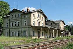
Former train station | ||
| ||
 Großpostwitz | ||
Location of Großpostwitz within Bautzen district 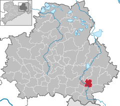
 | ||
| Coordinates: 51°7′N 14°27′E / 51.117°N 14.450°ECoordinates: 51°7′N 14°27′E / 51.117°N 14.450°E | ||
| Country | Germany | |
| State | Saxony | |
| District | Bautzen | |
| Municipal assoc. | Großpostwitz-Obergurig | |
| Government | ||
| • Mayor | Frank Lehmann | |
| Area | ||
| • Total | 16.42 km2 (6.34 sq mi) | |
| Population (2013-12-31)[1] | ||
| • Total | 2,785 | |
| • Density | 170/km2 (440/sq mi) | |
| Time zone | CET/CEST (UTC+1/+2) | |
| Postal codes | 02692 | |
| Dialling codes | 035938 | |
| Vehicle registration | BZ | |
| Website | www.grosspostwitz.de | |
.svg.png)
Großpostwitz (Sorbian Budestecy) is a municipality in the east of Saxony, Germany. It belongs to the district of Bautzen and lies south of the eponymous city.
Geography
The municipality is situated at the northern edge of the Lausitzer Bergland (Lusatian Hills) along the Spree. The Bundesstraße 96 passes Großpostwitz.
Villages
Several villages belong to the municipality:
- Berge (Zahor)
- Binnewitz (Bónjecy)
- Cosul (Kózły)
- Ebendörfel (Bělšecy)
- Eulowitz (Jiłocy)
- Großpostwitz (Budestecy)
- Klein Kunitz (Chójnička)
- Mehltheuer (Lubjenc)
- Rascha (Rašow)
- Denkwitz (Dźenikecy)
History
Within the German Empire (1871-1918), Großpostwitz was part of the Kingdom of Saxony.
References
- ↑ "Statistisches Landesamt des Freistaates Sachsen – Bevölkerung des Freistaates Sachsen jeweils am Monatsende ausgewählter Berichtsmonate nach Gemeinden" (PDF). Statistisches Landesamt des Freistaates Sachsen (in German). 6 September 2014.