Großheubach
| Großheubach | ||
|---|---|---|
| ||
 Großheubach | ||
Location of Großheubach within Miltenberg district 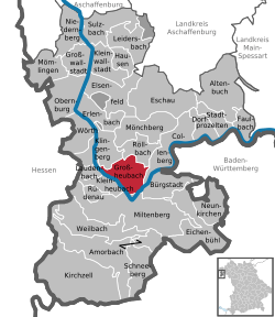 | ||
| Coordinates: 49°44′N 09°14′E / 49.733°N 9.233°ECoordinates: 49°44′N 09°14′E / 49.733°N 9.233°E | ||
| Country | Germany | |
| State | Bavaria | |
| Admin. region | Unterfranken | |
| District | Miltenberg | |
| Government | ||
| • Mayor | Günther Oettinger (CSU) | |
| Area | ||
| • Total | 19.00 km2 (7.34 sq mi) | |
| Population (2013-12-31)[1] | ||
| • Total | 5,139 | |
| • Density | 270/km2 (700/sq mi) | |
| Time zone | CET/CEST (UTC+1/+2) | |
| Postal codes | 63920 | |
| Dialling codes | 09371 | |
| Vehicle registration | MIL | |
| Website | www.grossheubach.de | |
Großheubach (or Grossheubach) is a market community in the Miltenberg district in the Regierungsbezirk of Lower Franconia (Unterfranken) in Bavaria, Germany.
Geography
Location
Großheubach lies in the Main valley and is framed by the Spessart and Odenwald ranges’ foothills. Belonging to Großheubach are the hamlets of Klotzenhof and Roßhof. The highest point in the municipal area is the 439 m-high Ospisrain. Großheubach also lies on the Fränkischer Rotwein Wanderweg (“Franconian Red Wine Hiking Trail”).
History
Earlier names for Großheubach are Heidebah and Grotzenheidbach. The area was first settled about 1000 BC, as witnessed by urnfields and graves. About 900, Großheubach had its first documentary mention. About 1200, the place was held by the Lords of Klingenberg, the Lords of Bickenbach and the Teutonic Knights. About 1300, the community’s first chapel was built on the Rulesberg (hill), now known as the Engelberg. From 1483, Großheubach belonged to the Archbishopric of Mainz, and did so until 1803. In 1612, the historic Town Hall was built. In 1630, a Capuchin monastery was founded on the Engelberg. In 1816, Großheubach became Bavarian. In 1828, the monastery was taken over by the Franciscans. In 1896, the old church was expanded and today’s parish church thereby came into being.
Politics
Community council
The council is made up of 20 council members with seats apportioned thus:[2]
- CSU 9 seats
- SPD 7 seats
- PWG 4 seats
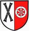
Coat of arms
The community’s arms might be described thus: Per pale, argent a saltire pattée sable and gules a wheel spoked of six of the first.
The black saltire (X-shaped cross) comes from a village court seal from 1654 and refers to the hegemony once exercised by the Teutonic Knights (although their coat of arms showed an upright cross). The Wheel of Mainz and the tinctures argent and gules (silver and red) refer to the community’s later feudal overlord, the Archbishopric of Mainz, which held Großheubach until the end of the Old Empire in 1803.
The arms have been borne since 1956.[3]
Culture and sightseeing
Buildings
Saint Peter’s Parish Church
In 1247, the church had its first priest, and in 1519, it acquired its first bell. In 1609, a massive fortress church was built in the Romanesque style with defensive towers, parapets and battlements. Between 1895 and 1897, the church underwent remodelling, giving it its current appearance. In 1949, the church acquired four bells. On 1 August 1958, the churchtower was destroyed in a storm. In 1987, the church was renovated.
Historic Town Hall

This was built in 1611 and 1612 by master builder Otto Oswald Heppeler in Old Franconian timber-frame style. The house served as a seat for a lower official of the Amt of Prozelten. The ground floor was used as a prison. Functioning as the house’s owners were Johann Schweikhard von Kronberg, Archbishop of Mainz and Elector, and Caspar Herr zu Eltz, Electoral Mainz Großhofmeister, councilman and Amtmann at Prozelten.
Abendanz’sches Haus
The Abendanz’sches Haus is a timber-frame house in Großheubach core built about 1600. Over the centuries, several conversions to the building were undertaken. After the restorations done between 1987 and 1990, the timber framing was exposed and the original façade was reconstructed. The house served as a dwelling for, among others, the wine merchant Johann Simon Abendanz and the last abbot of the Amorbach Monastery.
Engelberg Monastery
The Franciscan Engelberg Monastery with its well known pilgrimage church was founded about 1300. The building, built in 1630 for the Order of Friars Minor Capuchin, was on King Ludwig I’s orders turned over to the Franciscans, who still run the Monastery today. The Engelberg, the hill on which the Monastery stands, which is 250 m above sea level, can be reached over the 612 so-called Engelstaffeln (roughly, “Angel’s Steps”) made out of bunter.
Historic heathen cult site
Known as Hunnenstein or Heunenschüssel, it is found on a mountain ridge near the Engelberg Monastery. Carved crudely into a block of sandstone several metres tall are round markings.
Famous people
Sons and daughters of the town
- Guido Kratschmer (b. 10 January 1953), Decathlete and Olympic medallist
References
- ↑ "Fortschreibung des Bevölkerungsstandes". Bayerisches Landesamt für Statistik und Datenverarbeitung (in German). 31 December 2013.
- ↑ Gemeinderat 2008 - 2014
- ↑ Description and explanation of Großheubach’s arms
External links
| Wikimedia Commons has media related to Großheubach. |