Großer Müllroser See
| Großer Müllroser See | |
|---|---|
 | |
| Location | Brandenburg, district Oder-Spree, Schlaube Valley Nature Park |
| Primary inflows | Schlaube |
| Primary outflows | Schlaube |
| Basin countries | Germany |
| Max. length | 2900 m |
| Max. width | 640 m |
| Surface area | 1.32 km² |
| Max. depth | 8 m |
| Water volume | 4,34 Mio. m³ |
| Surface elevation | 41.6 m |
| Settlements | Müllrose |
The Großer Müllroser See is a lake in Brandenburg, Germany. It is located in the district Oder-Spree between the town Müllrose in the north and the municipality Mixdorf in the south. The lake covers an area of 1,32 km². At an elevation of 41,6 m, its depth is maximal 8 m.
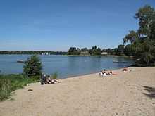
The lake is the largest water in the Schlaube Valley Nature Park and flown through by the river Schlaube, which runs over a distance of 20 kilometers through the Schlaube-Valley (German: Schlaubetal), a tunnel valley of the last glacial period. An approximately 9 kilometres long walking path leads around the lake. At the eastern and western shore there are public lidos/beaches, one of them with a diving tower. On the sea are operating some passenger ships. The watermill Müllrose at the northern shore was first mentioned in a document in 1275 and is still in use today.[1]
External links
![]() Media related to Großer Müllroser See at Wikimedia Commons
Media related to Großer Müllroser See at Wikimedia Commons
References
- ↑ Hermann Trebbin: Müllrose - Aus den Schicksalen und Kämpfen einer märkischen Landstadt. Nachdruck der Ausgabe von 1934. Hrsg.: Stadt Müllrose, Verlag Die Furt, Jacobsdorf 2003, ISBN 3-933416-45-0.