Große Arnspitze
| Große Arnspitze | |
|---|---|
 Große Arnspitze | |
| Elevation | 2,196 m above sea level (AA) (7,205 ft) |
| Prominence | 1,003 m ↓ Northwest of Neuleutasch → Reither Spitze |
| Isolation | 3.9 km → Upper Wettersteinspitze |
| Location | |
 Große Arnspitze | |
| Range | Wettersteingebirge, Northern Limestone Alps |
| Coordinates | 47°23′50″N 11°13′21″E / 47.3971306°N 11.2225417°ECoordinates: 47°23′50″N 11°13′21″E / 47.3971306°N 11.2225417°E |
| Geology | |
| Type | Wetterstein Limestone[1] |
| Age of rock | Triassic |
| Climbing | |
| Easiest route | Scharnitz – Arnspitzhütte – Große Arnspitze |
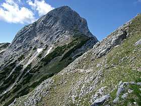
The Große Arnspitze is the highest peak in the Arnspitze Group in the Wettersteingebirge mountains. It is located west of Scharnitz in Austria. The border between Germany and Austria runs over its summit.
The normal climbing route, Weg 851, runs from Scharnitz westwards and below the Ahrntalköpfle to the Riedberg. Below this mountain the path bends to the southwest from the Arnspitzhütte, from whence it heads northwest to the summit.
References
- ↑ Geologische Karte von Bayern mit Erläuterungen (1:500.000). Bayerisches Geologisches Landesamt, 1998.
Sources
- Kompass Wander-, Bike und Skitourenkarte: Blatt 25 Zugspitze, Mieminger Kette (1:50.000). Kompass-Karten, Innsbruck 2008, ISBN 978-3-85491-026-8