Großdubrau
| Großdubrau | ||
|---|---|---|
| ||
 Großdubrau | ||
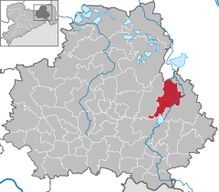
Location of Großdubrau within Bautzen district 
 | ||
| Coordinates: 51°15′N 14°28′E / 51.250°N 14.467°ECoordinates: 51°15′N 14°28′E / 51.250°N 14.467°E | ||
| Country | Germany | |
| State | Saxony | |
| District | Bautzen | |
| Government | ||
| • Mayor | Siegfried Schuster | |
| Area | ||
| • Total | 54.22 km2 (20.93 sq mi) | |
| Population (2013-12-31)[1] | ||
| • Total | 4,268 | |
| • Density | 79/km2 (200/sq mi) | |
| Time zone | CET/CEST (UTC+1/+2) | |
| Postal codes | 02694 | |
| Dialling codes | 035934 | |
| Vehicle registration | BZ | |
| Website | www.grossdubrau.de | |
Großdubrau, in Sorbian Wulka Dubrawa, is a municipality in the east of Saxony, Germany. It belongs to the district of Bautzen and lies north of the eponymous city.
Geography
The municipality is situated in the Upper Lusatian flatland.
Villages
Several villages belong to the municipality:
- Großdubrau with Großdubrau (Wulka Dubrawa), Kleindubrau (Mała Dubrawa), Brehmen (Brěmjo) and Crosta (Chróst)
- Commerau with Commerau (Komorow), Kauppa (Kupoj), Jetscheba (Jatřob) and Göbeln (Kobjelń)
- Klix with Klix (Klukš), Spreewiese, until 1911: Leichnam (Lichań), Särchen (Zdźar), Salga (Załhow), Neusärchen (Nowe Zdźarki)
- Quatitz with Quatitz (Chwaćicy), Dahlowitz (Dalicy), Jeschütz (Ješicy), Kronförstchen (Křiwa Boršć) and Margarethenhütte (Margarěćina hěta)
- Sdier with Sdier (Zdźěr) and Zschillichau (Čelchow)
References
- ↑ "Statistisches Landesamt des Freistaates Sachsen – Bevölkerung des Freistaates Sachsen jeweils am Monatsende ausgewählter Berichtsmonate nach Gemeinden" (PDF). Statistisches Landesamt des Freistaates Sachsen (in German). 6 September 2014.
| Wikimedia Commons has media related to Großdubrau. |
.svg.png)