Grip Lighthouse
 View of the lighthouse | |
 | |
| Location | Kristiansund, Norway |
|---|---|
| Coordinates | 63°14′01″N 07°36′33″E / 63.23361°N 7.60917°ECoordinates: 63°14′01″N 07°36′33″E / 63.23361°N 7.60917°E |
| Year first constructed | 1888 |
| Automated | 1977 |
| Foundation | Granite |
| Construction | Cast iron |
| Tower shape | Round |
| Markings / pattern | Red with white base |
| Height | 47 metres (154 ft) |
| Focal height | 67 metres (220 ft) |
| Range | 19 nautical miles (35 km) |
| Characteristic | Oc(2) WRG 8s |
| Racon | G |
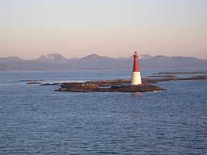
The Grip Lighthouse (Norwegian: Grip fyrstasjon) is located in Grip in the municipality of Kristiansund in Møre og Romsdal county, Norway. The lighthouse was built between 1885 and 1888 on the 7-metre (23 ft) high islet of Bratthårskollen, north of Gripholmen.[1]
The 47-metre (154 ft) tall lighthouse is a red cast iron tower on a white 16-metre (52 ft) granite stonemasonry base. This is the second tallest lighthouse tower in Norway. The lighthouse's range is 19 nautical miles (35 km; 22 mi), and the white, red, or green light, depending on direction, is occulting every eight seconds.[2]
The islet is barren rock with just the lighthouse tower, a concrete boathouse, and two wharves. The lighthouse keepers lived inside the lighthouse tower. A radio beacon was operated between 1947 and 1986, which was replaced with a frequency-agile racon signalling "G" with a range of 4 nm. The lighthouse was electrified in 1932, and is unmanned since it was automated in 1977. In 2000, it became protected as a cultural heritage site. The pilot station was shut down in 1969.[1]
See also
References
- ↑ 1.0 1.1 Store norske leksikon. "Grip fyr" (in Norwegian). Retrieved 2010-11-22.
- ↑ Kystverket (2008). Norske Fyrliste 2008 (PDF) (in Norwegian). ISBN 978-82-450-0628-5.
External links
 Media related to Grip fyr at Wikimedia Commons