Grič pri Klevevžu
| Grič pri Klevevžu | |
|---|---|
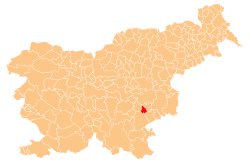
_location_map.svg.png) Grič pri Klevevžu Location in Slovenia | |
| Coordinates: 45°54′19.02″N 15°13′50.99″E / 45.9052833°N 15.2308306°ECoordinates: 45°54′19.02″N 15°13′50.99″E / 45.9052833°N 15.2308306°E | |
| Country |
|
| Traditional region | Lower Carniola |
| Statistical region | Southeast Slovenia |
| Municipality | Šmarješke Toplice |
| Area | |
| • Total | 1.46 km2 (0.56 sq mi) |
| Elevation | 226.8 m (744.1 ft) |
| Population (2002) | |
| • Total | 44 |
| [1] | |
Grič pri Klevevžu is a settlement in the Municipality of Šmarješke Toplice in southeastern Slovenia. The area is part of the historical region of Lower Carniola. The municipality is now included in the Southeast Slovenia statistical region.[2]
Name
The name Grič pri Klevevžu literally means 'hill near Klevevž'. The name comes from medieval Klevevž Castle (German: Klingenfels),[3] first mentioned in written documents dating to 1267. It was burned down by the Partisans during the Second World War.[4]
Mass graves
Grič pri Klevevžu is the site of three known mass graves associated with the Second World War. The Klevevž 1–3 mass graves (Slovene: Grobišče Klevevž 1–3) are located north of the settlement. They are also known as the Kačja Rid, Bričevka, or Jurjevci mass graves. They contain the remains of Slovene and Romani civilians murdered by the Partisans in the spring and early summer of 1942 while the staff of the Krka Detachment was at Klevevž Castle. The first grave is located in the woods 30 m from the main road and 10 m from a forest path; it contains the remains of 30 victims.[5] The second grave lies in front of a sinkhole next to a path in the woods, about 180 m from the main road, and contains the remains of several dozen victims.[6] The third grave lies in front of another sinkhole next to the same path in the woods, about 220 m from the main road, and contains the remains of several dozen victims.[7]
References
- ↑ Statistical Office of the Republic of Slovenia
- ↑ Šmarješke Toplice municipal site
- ↑ Leksikon občin kraljestev in dežel zastopanih v državnem zboru, vol. 6: Kranjsko. 1906. Vienna: C. Kr. Dvorna in Državna Tiskarna, p. 83. (Slovene)
- ↑ "EŠD 8660". Registry of Immovable Cultural Heritage (in Slovenian). Ministry of Culture of the Republic of Slovenia. Retrieved 25 May 2011.
- ↑ Klevevž 1 Mass Grave on Geopedia (Slovene)
- ↑ Klevevž 2 Mass Grave on Geopedia (Slovene)
- ↑ Klevevž 3 Mass Grave on Geopedia (Slovene)
External links
| ||||||||||||||||||
