Grez-Neuville
| Grez-Neuville | |
|---|---|
|
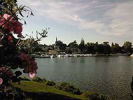
La Mayenne, l'église et le port de Neuville vue de Grez. | |
 Grez-Neuville | |
|
Location within Pays de la Loire region  Grez-Neuville | |
| Coordinates: 47°36′07″N 0°40′59″W / 47.601837°N 0.683041°WCoordinates: 47°36′07″N 0°40′59″W / 47.601837°N 0.683041°W | |
| Country | France |
| Region | Pays de la Loire |
| Department | Maine-et-Loire |
| Arrondissement | Segré |
| Canton | Lion-d'Angers |
| Intercommunality | Communauté de communes de la région du Lion-d'Angers |
| Government | |
| • Mayor (2001–2008) | Jean-Yves Surrault |
| Area1 | 48 km2 (19 sq mi) |
| Population (2006)2 | 1,436 |
| • Density | 30/km2 (77/sq mi) |
| INSEE/Postal code | 49155 / 49220 |
| Elevation | 16–97 m (52–318 ft) |
|
1 French Land Register data, which excludes lakes, ponds, glaciers > 1 km² (0.386 sq mi or 247 acres) and river estuaries. 2 Population without double counting: residents of multiple communes (e.g., students and military personnel) only counted once. | |
Grez-Neuville is a commune in the Maine-et-Loire department in western France.
Geography
The Oudon River forms part of the commune’s northern border before joining the Mayenne River, which flows south through the commune.
See also
| Wikimedia Commons has media related to Grez-Neuville. |