Grenzgipfel
| Grenzgipfel | |
|---|---|
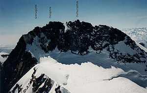 The Grenzgipfel to the left of the Ostspitze and the Dufourspitze (seen from Nordend) | |
| Elevation | 4,618 m (15,151 ft)[1] |
| Prominence | 15 m (49 ft) |
| Parent peak | Monte Rosa |
| Listing | Italian region high point |
| Location | |
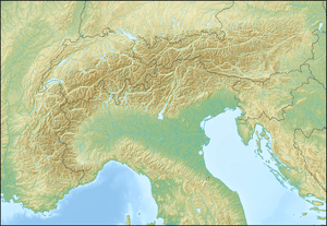 Grenzgipfel Location in the Alps | |
| Location |
Piedmont, Italy Valais, Switzerland |
| Range | Pennine Alps |
| Coordinates | 45°56′12.3″N 7°52′04.8″E / 45.936750°N 7.868000°ECoordinates: 45°56′12.3″N 7°52′04.8″E / 45.936750°N 7.868000°E |
| Climbing | |
| First ascent | 12 August 1848 by Johann Madutz and Matthias zum Taugwald.[2] |
The Grenzgipfel (4,618 m)[3] is a subpeak of Monte Rosa (Pennine Alps), located on the border between Italy and Switzerland. In the German language the peak's name means 'frontier summit'.
The Grenzgipfel is the highest summit on the Italian side of Monte Rosa and the highest point of the entire border between Italy and Switzerland; it is also the culminating point of the Italian region of Piedmont and of the Ticino drainage basin.
The closest locality is Macugnaga, which is located east of Monte Rosa.
References
- ↑ Retrieved from the Swisstopo topographic maps.
- ↑ Gottlieb Studer, Über Eis und Schnee: Die höchsten Gipfel der Schweiz und die Geschichte ihrer Besteigung, Volume 2, Schmid, Francke & Company, 1899, pp. 78-85
- ↑ According to Collomb, the 'false Grenzgipfel' is 4,618 m, while the 'true Grenzgipfel' is 4,596 m. Collomb, Robin G., Pennine Alps Central, London: Alpine Club, 1975, p. 172