Grenadier Island, New York

Grenadier is a relatively small island, approximately 1,290 acres (5.2 km2) in size, 2.3 miles (3.7 km) long and 1.4 miles (2.3 km) wide. It is located two miles (3 km) out from Mud Bay in Cape Vincent, New York. It was visited by General Wilkinson and his troops after retreating from the St. Lawrence River in 1812, when he landed his fleet in Basin Harbor.
The first official settlement was by John Mitchel in 1813, who built a cabin there after the war, followed by the Bedford family a year later. At one point, the island's population consisted of fourteen families. More historical information can be found here.
There are three buildings from the 19th century still standing on the island: the Schoolhouse, the Humphrey farm house, and the Stone House. The Stone House is located in the North East corner of the Island. The Humphrey house and Schoolhouse are both in the middle if the island, closer to the northern shore.
Schoolhouse
_Schoolhouse.jpg)
The Schoolhouse is located in the middle of the island, It has a single room with an outhouse situated behind it. In the early 20th century it had around 13 students. (seen in the photo on the right)
Humphrey Farm House
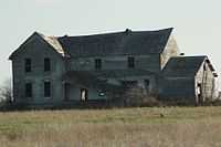
The Humphrey farm house, also known as the "Carbide House", was a two story home, with a basement and an attic (seen in the photo on the right). The house has been abandoned for many decades, and has been gradually falling in upon itself for many years (as of 2014).
Grenadier Island and its Unofficial Mayor
The Grenadier Island in this story is located in the Thousand Islands region, on the Ontario side of the border, near Rockport. The international border with New York lies just a few hundred feet off its south shore.
Bibliography
- http://jefferson.nygenweb.net/bedfordp.htm
- http://www.thousandislandslife.com/BackIssues/Archive/tabid/393/articleType/ArticleView/articleId/79/Grenadier-Island-and-its-Unofficial-Mayor.aspx
- http://www.rays-place.com/history/ny/cape-vincent-ny.htm (Visited March 8, 2007)
- http://freepages.genealogy.rootsweb.com/~twigs2000/cv.html (Visited March 7, 2007)
Coordinates: 44°02′33″N 76°21′51″W / 44.04250°N 76.36417°W