Greer Township, Warrick County, Indiana
| Greer Township Warrick County | |
|---|---|
| Township | |
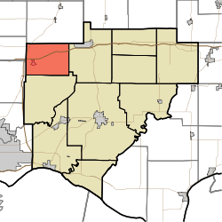 Location in Warrick County | |
| Coordinates: 38°10′24″N 87°24′45″W / 38.17333°N 87.41250°WCoordinates: 38°10′24″N 87°24′45″W / 38.17333°N 87.41250°W | |
| Country | United States |
| State | Indiana |
| County | Warrick |
| Government | |
| • Type | Indiana township |
| Area | |
| • Total | 27.54 sq mi (71.3 km2) |
| • Land | 27.17 sq mi (70.4 km2) |
| • Water | 0.37 sq mi (1.0 km2) 1.34% |
| Elevation | 394 ft (120 m) |
| Population (2010) | |
| • Total | 1,883 |
| • Density | 69.3/sq mi (26.8/km2) |
| ZIP codes | 47613, 47619, 47639 |
| GNIS feature ID | 0453356 |
Greer Township is one of ten townships in Warrick County, Indiana, United States. As of the 2010 census, its population was 1,883 and it contained 769 housing units.[1]
Geography
According to the 2010 census, the township has a total area of 27.54 square miles (71.3 km2), of which 27.17 square miles (70.4 km2) (or 98.66%) is land and 0.37 square miles (0.96 km2) (or 1.34%) is water.[1]
History
Greer Township was formed out of Hart Township in June 1853.
Cities, towns, villages
Unincorporated towns
- Rosebud at 38°11′40″N 87°24′45″W / 38.194490°N 87.412514°W
- Wheatonville at 38°11′14″N 87°27′41″W / 38.187267°N 87.461405°W
(This list is based on USGS data and may include former settlements.)
Adjacent townships
- Barton Township, Gibson County (north)
- Hart Township (east)
- Campbell Township (south)
- Johnson Township, Gibson County (west)
- Scott Township, Vanderburgh County (west)
Cemeteries
The township contains these four cemeteries: Northview, Susott, Williams and Zion.
School districts
- Warrick County School Corporation
Political districts
- Indiana's 8th congressional district
- State House District 75
- State Senate District 50
References
- United States Census Bureau 2007 TIGER/Line Shapefiles
- United States Board on Geographic Names (GNIS)
- IndianaMap
- ↑ 1.0 1.1 "Population, Housing Units, Area, and Density: 2010 - County -- County Subdivision and Place -- 2010 Census Summary File 1". United States Census. Retrieved 2013-05-10.
External links
| |||||||||||||||||||||||||