Greenbrier State Forest
| Greenbrier State Forest | |
| West Virginia State Forest | |
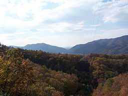 Howard Creek gap in Greenbrier Mountain | |
| Country | United States |
|---|---|
| State | West Virginia |
| County | Greenbrier |
| Elevation | 3,169 ft (965.9 m) |
| Coordinates | 37°44′22″N 80°20′00″W / 37.73944°N 80.33333°WCoordinates: 37°44′22″N 80°20′00″W / 37.73944°N 80.33333°W |
| Area | 5,133 acres (2,077.3 ha) [1] |
| Established | 1938 [1] |
| Management | West Virginia Division of Natural Resources and West Virginia Division of Forestry |
| Owner | West Virginia Division of Forestry |
| Nearest city | White Sulphur Springs, West Virginia |
 Location of Greenbrier State Forest in West Virginia
| |
| Website: Greenbrier State Forest | |
Greenbrier State Forest is a 5,133-acre (21 km2)[1] state forest between Lewisburg and White Sulphur Springs in Greenbrier County, West Virginia, USA. Greenbrier State Forest is located on Harts Run, a tributary of Howard Creek, and contains historic Kate's Mountain (3,330 feet/1,015 m).
Greenbrier State Forest features 13 miles (21 km) of hiking trails, many of which are also suitable for mountain biking. There is a heated pool, numerous picnic sites with two shelters, archery range, muzzleloading rifle range, horseshoes, 18 basket disc golf course, and volleyball. A naturalist provides nature and recreational events during the summer months.
Hunting and fishing are permitted; state licenses are required.
Accommodations include 12 one- and two-bedroom cabins, 1 handicapped accessible cabin, and 16 campsites with electric hookups and water available at the central bathhouse.
References
- ↑ 1.0 1.1 1.2 "Greenbrier State Forest". West Virginia Division of Forestry. Retrieved 2008-10-10.