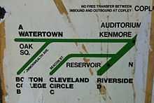
Green Line "A" Branch
| Green Line "A" Branch Watertown Line | ||||||||||||||||||||||||||||||||||||||||||||||||||||||||||||||||||||||||||||||||||||||||||||||||||||||||||||||||||||||||||||||||||||||||||||||||||||||||||||||||||||||||
|---|---|---|---|---|---|---|---|---|---|---|---|---|---|---|---|---|---|---|---|---|---|---|---|---|---|---|---|---|---|---|---|---|---|---|---|---|---|---|---|---|---|---|---|---|---|---|---|---|---|---|---|---|---|---|---|---|---|---|---|---|---|---|---|---|---|---|---|---|---|---|---|---|---|---|---|---|---|---|---|---|---|---|---|---|---|---|---|---|---|---|---|---|---|---|---|---|---|---|---|---|---|---|---|---|---|---|---|---|---|---|---|---|---|---|---|---|---|---|---|---|---|---|---|---|---|---|---|---|---|---|---|---|---|---|---|---|---|---|---|---|---|---|---|---|---|---|---|---|---|---|---|---|---|---|---|---|---|---|---|---|---|---|---|---|---|---|---|---|
|
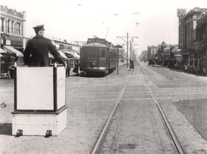
A Watertown-bound trolley on Brighton Avenue, ca. 1910 | ||||||||||||||||||||||||||||||||||||||||||||||||||||||||||||||||||||||||||||||||||||||||||||||||||||||||||||||||||||||||||||||||||||||||||||||||||||||||||||||||||||||||
| Overview | ||||||||||||||||||||||||||||||||||||||||||||||||||||||||||||||||||||||||||||||||||||||||||||||||||||||||||||||||||||||||||||||||||||||||||||||||||||||||||||||||||||||||
| Type | Light rail | |||||||||||||||||||||||||||||||||||||||||||||||||||||||||||||||||||||||||||||||||||||||||||||||||||||||||||||||||||||||||||||||||||||||||||||||||||||||||||||||||||||||
| System | Green Line | |||||||||||||||||||||||||||||||||||||||||||||||||||||||||||||||||||||||||||||||||||||||||||||||||||||||||||||||||||||||||||||||||||||||||||||||||||||||||||||||||||||||
| Status | closed and abandoned | |||||||||||||||||||||||||||||||||||||||||||||||||||||||||||||||||||||||||||||||||||||||||||||||||||||||||||||||||||||||||||||||||||||||||||||||||||||||||||||||||||||||
| Locale | Boston and Watertown | |||||||||||||||||||||||||||||||||||||||||||||||||||||||||||||||||||||||||||||||||||||||||||||||||||||||||||||||||||||||||||||||||||||||||||||||||||||||||||||||||||||||
| Termini |
Park Street Station, Boston Watertown Yard | |||||||||||||||||||||||||||||||||||||||||||||||||||||||||||||||||||||||||||||||||||||||||||||||||||||||||||||||||||||||||||||||||||||||||||||||||||||||||||||||||||||||
| Operation | ||||||||||||||||||||||||||||||||||||||||||||||||||||||||||||||||||||||||||||||||||||||||||||||||||||||||||||||||||||||||||||||||||||||||||||||||||||||||||||||||||||||||
| Opening |
1856 (first sections, as part of Cambridge Horse Railroad) 1889 (electrification on route from Oak Square to Boston)[1] | |||||||||||||||||||||||||||||||||||||||||||||||||||||||||||||||||||||||||||||||||||||||||||||||||||||||||||||||||||||||||||||||||||||||||||||||||||||||||||||||||||||||
| Closed | 20 June 1969 | |||||||||||||||||||||||||||||||||||||||||||||||||||||||||||||||||||||||||||||||||||||||||||||||||||||||||||||||||||||||||||||||||||||||||||||||||||||||||||||||||||||||
| Operator(s) | Various private companies, then M.T.A., then MBTA | |||||||||||||||||||||||||||||||||||||||||||||||||||||||||||||||||||||||||||||||||||||||||||||||||||||||||||||||||||||||||||||||||||||||||||||||||||||||||||||||||||||||
| Character | Underground from Park Street to Kenmore, central median from Kenmore to Packards Corner, street-running from Packards Corner to Watertown Yard | |||||||||||||||||||||||||||||||||||||||||||||||||||||||||||||||||||||||||||||||||||||||||||||||||||||||||||||||||||||||||||||||||||||||||||||||||||||||||||||||||||||||
| Rolling stock | PCC streetcars (1941-1969) | |||||||||||||||||||||||||||||||||||||||||||||||||||||||||||||||||||||||||||||||||||||||||||||||||||||||||||||||||||||||||||||||||||||||||||||||||||||||||||||||||||||||
| Technical | ||||||||||||||||||||||||||||||||||||||||||||||||||||||||||||||||||||||||||||||||||||||||||||||||||||||||||||||||||||||||||||||||||||||||||||||||||||||||||||||||||||||||
| No. of tracks | 2 (some underground sections had 4 tracks) | |||||||||||||||||||||||||||||||||||||||||||||||||||||||||||||||||||||||||||||||||||||||||||||||||||||||||||||||||||||||||||||||||||||||||||||||||||||||||||||||||||||||
| Track gauge | 4 ft 8 1⁄2 in (1,435 mm) | |||||||||||||||||||||||||||||||||||||||||||||||||||||||||||||||||||||||||||||||||||||||||||||||||||||||||||||||||||||||||||||||||||||||||||||||||||||||||||||||||||||||
| ||||||||||||||||||||||||||||||||||||||||||||||||||||||||||||||||||||||||||||||||||||||||||||||||||||||||||||||||||||||||||||||||||||||||||||||||||||||||||||||||||||||||
The "A" Branch or Watertown Branch was a streetcar line in the Boston, Massachusetts area, operating as a branch of the Massachusetts Bay Transportation Authority Green Line. Since 1969, it has been replaced by the 57 bus, though the tracks remained continuous until March 1994.
History
The line started as a horse car street railway, as a branch of the Cambridge Horse Railroad. The branch split at Central Square, Cambridge, and crossed the Charles River on the River Street Bridge into Allston. It continued on through Union Square, and in 1858 was opened to Oak Square in the center of Brighton. The part east of Union Square later became part of the 64 bus route.
The first electric trolleys in Boston ran between the Allston Carhouse (northeast of Union Square) and Park Square downtown, on tracks running south on Harvard Street, east on Beacon Street, south on Massachusetts Avenue, and east on Boylston Street. These first ran on January 1, 1889, on tracks that had been built for horse cars.
On June 13, 1896, tracks opened from Union Square east along North Beacon Street and Commonwealth Avenue to Kenmore Square, merging with the existing tracks on Beacon Street. That year, the western terminal was also extended to just shy of Newton Corner, with Newton Corner service beginning May 21, 1898. On December 9, 1912, the route was extended north to Watertown on tracks that had been used by routes from Cambridge to Newton Corner since 1900. During the early part of the 20th century, the line was also used for light rail freight service.[1]
Cars on the line began using the Tremont Street Subway to turn around at Park Street November 8, 1897, via the Boylston Street Incline at the Public Garden. The Boylston Street Subway was opened to an incline in Kenmore Square on October 3, 1914, and the jog on Massachusetts Avenue was eliminated. The Blandford Street Portal, on Commonwealth Avenue west of Kenmore, opened October 23, 1932, marking the last change in the route of the service. In 1941, the line became the first line in Boston to have primary service with the new PCC streetcars, which replaced the Types 4 and 5 cars then in service.[1]
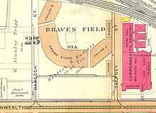
Prior to 1967, when the current letters were assigned to the Green Line's branches, the Watertown Line was the 69 Watertown-Park Street route. The 57, the line's current number, was actually assigned to Heath Street short-turn trips on the "E" Branch. The line was assigned the letter "A" because it was the northernmost branch. Turnback loops existed at Union Square and Oak Square, as well as the Watertown terminal. Additionally, from 1915 to January 15, 1962, a loop existed at Boston University, which until 1953 was the site of Braves Field, for special events along the part of the line concurrent with the "B" Branch.
Closure

The opening of the Green Line "D" Branch (Riverside Branch) in 1959 caused streetcar lines in Cambridge running out of Harvard Square to be converted to trackless trolley, and the newly freed PCC streetcars were reassigned to the Riverside Branch. However, the 1940s-era PCC fleet was aging, and maintaining five different types of PCCs complicated mechanical work.[2] By the late 1960s, wear and tear and a lack of replacements caused a shortage of Green Line streetcars, and the MBTA announced the closure of the A branch on a "trial" basis.[2][3] The "A" Branch was chosen for closure because much of its route consisted of street running sections from Watertown to Packards Corner, and in 1964 there had been objections to keeping the service past Newton Corner.[1] Streetcars last ran on June 20, 1969, with the 57 Watertown-Kenmore via Newton and Brighton bus route beginning the next day.
The legacy tracks remained after 1969, being used for several decades to allow Green Line streetcars to reach the Watertown Carhouse for maintenance. The last use of the line was in 1993, when the fleet of PCC streetcars used for the Ashmont-Mattapan High Speed Line was refurbished at the Watertown carhouse.[1] The electrified overhead wire was finally removed in March 1994.[4]
Additional overhead infrastructure, as well as the tracks themselves, were mainly removed by the end of the summer of 1996 as part of a resurfacing project on North Beacon Street. Remnants of the tracks are still visible today in the Watertown Yard bus terminal (no longer used for railcar maintenance), as well as a short stub track at Packard's Corner, where the "A" branch used to diverge from the "B" branch. This stub, now just a few feet long, was formerly long enough to be used as a siding for disabled streetcars.
Restoration of the "A" branch was advocated to provide a one-seat ride to downtown Boston from the northern corridor (rather than requiring a transfer at Kenmore), but was ruled too costly and less safe compared to the replacement bus service.[3]
Route 57
The #57 bus is replacement service for the A Branch. The service follows the same original streets with many identical stops and terminates at Watertown Yard. Since free transfers were eliminated in October 1961, Watertown riders had to pay a double fare to continue downtown when the 57 bus began. Beginning on January 1, 2007, riders using a CharlieCard are charged one subway fare for a combined local bus and subway trip. Large portions of the line are also served by the numbers 501, 502, 503,and 504 express routes to downtown via the Mass Pike. In 2011, due to severe overcrowding during the rush hour times, a short-turn variant, Route 57A, was created, operating service only up to Oak Square. 57A does not operate on weekends.
Currently, Route 57 operates as a very busy key bus route on the MBTA Bus system. An average trip from Kenmore to Watertown takes 25 to 28 minutes depending on traffic. One early-morning trip also serves Haymarket. Route 57 is based at the Albany Street Bus Facility during weekday rush hours and midday service, and is based at the Cabot Garage at other times of the day, including full-time operation on weekends and holidays.
Map

References
- ↑ 1.0 1.1 1.2 1.3 1.4 Moore, Scott. "The Watertown Line". NETransit. Archived from the original on 3 February 2002. Retrieved 10 September 2011.
- ↑ 2.0 2.1 Moore, Scott. "Boston's Green Line Crisis". NETransit. Archived from the original on 22 February 2007. Retrieved 10 September 2011.
- ↑ 3.0 3.1 St. Martin, Greg (21 June 2009). "Where did the ‘A’ Line go, anyway?". Boston Metro. Archived from the original on 3 May 2010. Retrieved 10 September 2011.
- ↑ Belcher, Jonathon (20 July 2011). "Changes to Transit Service in the MBTA District" (PDF). Retrieved 10 September 2011.
External links
| Wikimedia Commons has media related to Green Line "A" Branch. |
- MBTA - Route 57 Watertown Yard - Kenmore Sta. via Newton Corner & Brighton Center
- Slideshow of Allston, showing some streetcar images with their modern-day counterparts along the route
| ||||||||||||||||||||||||||||||||||||||||||||||||||||||||||