Green Creek (Fishing Creek)
_in_springtime.JPG)
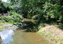
Green Creek is a tributary of Fishing Creek in Columbia County, Pennsylvania. At 12.7 miles (20.4 km) long, it is the third-longest tributary of Fishing Creek, after Huntington Creek and Little Fishing Creek.[1] The creek flows through Jackson Township, Greenwood Township, and Orange Township. It significantly increases the size of Fishing Creek when it flows into it. Some of the first settlers of the watershed arrived in the 1780s. The creek's watershed has an area of 36.80 square miles.
Course
Green Creek begins in central Jackson Township, near the community of Waller. It flows south, almost immediately entering a valley. After a short distance, it turns southeast, and then southwest. The creek turns southeast again in southern Jackson Township and exits the township.[2] Upon exiting Jackson Township, it flows into Greenwood Township. Here, it flows past O'Brien Hill, turning southwest and then south, following Pennsylvania Route 254. In Rohrsburg, the creek crosses Pennsylvania Route 254 receives the tributary Little Green Creek. Shortly downstream, the tributary Mud Run flows into Green Creek. Green Creek then exits Greenwood Township.[3] The creek then enters Orange Township and flows past Round Top. It then turns southwest and enters a plain. Shortly afterwards, it reaches its confluence with Fishing Creek, just west of Orangeville.[4]
Green Creek joins Fishing Creek 10.84 miles (17.45 km) upstream of the latter creek's mouth.[5]
Tributaries
Named tributaries of Green Creek include Mud Run, Rickard Hollow, and Little Green Creek.[6]
Geography and geology
There are oil deposits on Green Creek.[7] North Mountain is 4 miles (6.4 km) from the headwaters of the creek.[8] Parts of the creek experience erosion along their banks. A valley known as Greenwood Valley is located in the creek's watershed. The creek also has a floodplain known as the Green Creek Floodplain.[9]
The size of Fishing Creek is increased significantly by Green Creek flowing into it.[10]
Watershed
The watershed of Green Creek has an area of 36.80 square miles.[5] There is significant agricultural activity in the Greenwood Valley part of the Green Creek watershed.[9]
History
In 1778, Moses Van Campen participated in a scouting expedition that went, among other places, up Green Creek.[7] Historically, one of the most heavily-used Indian paths in the area had a segment that followed Green Creek from its mouth upstream to Rohrsburg.[8] Greenwood Valley was settled by 1786 or 1787. Early settlers in the valley of Green Creek itself included the four Mather brothers, George and William McMichael, Joshua Robbins, and Archibald Patterson and their families.[11]
In 1800, Jacob Lunger (who was formerly a resident of Northampton County, Pennsylvania), settled on Green Creek in Jackson Township. Five years later, Abraham Whiteman settled at the creek's headwaters. A sawmill was once built on the creek by Abraham Kline. Joseph Fullmer constructed the first flouring mill in Rohrsburg on Green Creek and also built another flowering mill on the creek downstream of Rhorsburg. The latter mill was later owned by Jonas Hayman and J.H. Ikeler. From 1832 to 1856, there was a fulling and carding mill on the creek upstream of Rohrsburg.[8]
A queen truss covered bridge known as the Patterson Covered Bridge was built across Green Creek in 1875 by Frank Derr.[12]
The August 19, 1890 Columbia/Luzerne County Tornado started in the watershed of Green Creek and traveled east-northeast for several dozen miles.[13]
The name that the Native Americans used to refer to Green Creek is unknown.[7]
The waters of Green Creek are navigable and were considered to be a public highway in the 1800s.[14]
Biology
The riparian buffer of Green Creek is relatively narrow. There are growing patches of purple loosestrife along the creek. There are significant growths of hemlock in the Green Creek Floodplain.[9]
Green Creek is stocked with trout.[15]
See also
References
- ↑ Google Maps, 2014, retrieved May 7, 2014
- ↑ USGS (1979), jackson.jpg, retrieved May 7, 2014
- ↑ USGS (1979), greenwoo.jpg, retrieved May 7, 2014
- ↑ USGS (1979), orangmpl.jpg, retrieved May 7, 2014
- ↑ 5.0 5.1 Pennsylvania Gazetteer of Streams, November 2, 2001, p. 67, retrieved May 7, 2014
- ↑ http://viewer.nationalmap.gov/viewer/
- ↑ 7.0 7.1 7.2 John Gosse Freeze (1888), A History of Columbia County, Pennsylvania: From the Earliest Times, retrieved May 7, 2014
- ↑ 8.0 8.1 8.2 J.H. Beers (1915), Historical and Biographical Annals of Columbia and Montour Counties, Pennsylvania, retrieved May 7, 2014
- ↑ 9.0 9.1 9.2 The Pennsylvania Science Office of The Nature Conservancy (2004), Columbia County Natural Areas Inventory 2004, retrieved May 7, 2014
- ↑ Chapter XIII - Mount Pleasant and Orange Townships History of Columbia and Montour Counties, Pennsylvania, 1887, retrieved May 7, 2014
- ↑ Edwin M. Barton, COLUMBIA COUNTY TWO HUNDRED YEARS AGO, retrieved May 7, 2014
- ↑ Patterson Covered Bridge, retrieved May 7, 2014
- ↑ August 19, 1890 Columbia/Luzerne County Tornado, retrieved May 7, 2014
- ↑ Pennsylvania (1894), Index to Local Legislation in Pennsylvania from 1700 to 1892, retrieved May 7, 2014
- ↑ Chapter § 93.9k. Stream Classification list, December 2007, retrieved May 7, 2014
External links
| Wikimedia Commons has media related to Green Creek (Fishing Creek). |