Grebbe line
| Grebbe line | |
|---|---|
| Netherlands | |
|
Grebbe line nearby Scherpenzeel | |
| Type | Defensive line |
| Site information | |
| Controlled by | Netherlands |
| Site history | |
| Built | 1745–1940 |
| In use | 1745–1951 |
| Materials | Flooded plains, sluices, earth walls, brick, concrete, steel |
| Battles/wars | Battle of the Grebbeberg |

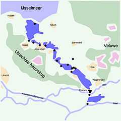
The Grebbe Line (Dutch: Grebbelinie) was a forward defence line of the Dutch Water Line, based on inundation. The Grebbe Line ran from the Grebbeberg in Rhenen northwards until the IJsselmeer.
Early history and first decommissioning
The Grebbe Line was first established in 1745 as a line of defense to protect the Netherlands from invading armies. If an invasion was imminent, parts of the area between Spakenburg and the Grebbeberg were to be flooded. Until World War II it was never actually used for this purpose; an attempt was made in 1794 to establish a defensive line against the invading French army under General Jean-Charles Pichegru, but the joint English-Dutch army abandoned the line when the French troops approached.
Throughout the 19th century the Grebbe line was maintained as a defensive line. However since no attacks appeared likely it was deemed less necessary to maintain the costly fortifications, and in 1926 a large part of the fortifications was decommissioned.
World War II
In 1939 the disused line was once again fortified against a German attack on the Netherlands, but due to cost and skills issues (soldiers were used as labourers) the earthworks were not well-constructed. In the 1939 plans the line would fulfill its ancient task as a forward line of defensive. However, in February 1940, the new Dutch commander in chief General Henri Winkelman decided to make the Grebbe line the main defensive line in the central sector of the Dutch defences. The Grebbe Line was deemed less useful as the modern German field artillery could reach the main cities Utrecht and Amsterdam from their positions opposing the defences.
Meanwhile, the Germans were aware of the line and its configuration. Before the war German spies had visited the zoo at Rhenen using its lookout tower to map the defences there. When the Germans attacked in May 1940, the Dutch army managed to defend the Grebbe line for three consecutive days, much to the surprise of the Germans. The Battle of the Grebbeberg saw the fiercest fighting, during which 420 Dutch and approximately 250 German soldiers were killed.
Directly after the cessation of hostilities a war cemetery was established at the Grebbeberg location by the German authorities.
The Grebbe line was permanently decommissioned by the Dutch Government in 1951.
Pantherstellung
During the war the Germans made use of the Grebbe line to create their own defence line called the Pantherstellung.[1] On 26 October 1944 General Walter Model initiated the building of the Pantherstellung. At that time it was clear that the enemy would not enter from the west but from the south. The Germans wanted to protect the Holland region because of the V-2 rocket attacks on London. The Germans didn't want to lose the ability to fire the rockets and wanted to prevent the Allies from reaching the IJsselmeer. The Germans had to make some changes to the design, because the threat was expected from the south. From Veenendaal to Amersfoort the defence line had the same configuration as the Grebbe line.
See also
Dutch waterlines
- Defence Line of Amsterdam
- Dutch Water Line
- IJssel Line
- Maas Line
- Peel-Raam Line
Other
References
- ↑ http://www.grebbelinie.nl/page/pantherstellung Panthestellung