Great Gidding
| Great Gidding | |
 Great Gidding |
|
| OS grid reference | TL117830 |
|---|---|
| Shire county | Cambridgeshire |
| Region | East |
| Country | England |
| Sovereign state | United Kingdom |
| Postcode district | PE28 |
| Dialling code | 01832 |
| EU Parliament | East of England |
|
|
Coordinates: 52°26′02″N 0°21′29″W / 52.434°N 0.358°W
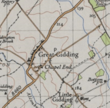
Great Gidding in Huntingdonshire[1] (now part of Cambridgeshire), England is a village and parish near Sawtry north west of Huntingdon. It has a Church of England primary school, playing field, corner shop, village hall and several local businesses. There is one pub in the village, The Fox and Hounds. Surrounding towns and cities are Huntingdon, Oundle and Peterborough. It is a small village in the East of England, very rural and close to the A1 road.
In 1870 Great Gidding was described as
- GIDDING (Great), a parish in the district of Oundle and county of Huntingdon; on Alconbury brook, adjacent to Northamptonshire, 6 miles SW by S of Stilton, and 6½ SW of Holme r. station. Post town, Hamerton, under St.[2]
It had a population of 363 according to the 2011 census.[3]
Census data
Age structure
Through comparing census data of both 2001 and 2011 we can see that in 2011 there were fewer young people but more old people. This is seen as in 2011 there were 101 people over 60 while 2001 had 73. In 2001 117 people were 29 and below while 2011 had only 106 people.[4] Therefore the mean age is different because in 2011 its 42.7 while 2001 was 37.57 [5] This also gives further evidence to the current ageing population of the country
Marital and civil partnership status
In 2001 the large majority 173 out of 277 people were married, remarried or technically still married. 53 were widowed or divorced and 51 are single (never married).[6] In 2011 however there was the added option of same-sex civil partnerships. Of this 4 out of the 304 people were in a same-sex civil partnership and 56.9% were married and 7 technically married. 24.7% were single (never married) while 45 people where divorced or widowed respectively.[7]
Religion
In 2001, the village was 73% Christian and 11.6% no religion, with five people who identified as Hindu. In 2011, the village was 63% Christian and 21.5% no religion, with five Hindus, five Jews, four Muslims, and two Buddhists.[8][9]
History
The village
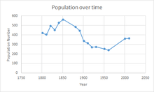
The population peaked around 1850, when the census tallied 560 people, and reached its lowest point in 1960, when the census tallied 230 people. The population has been stable for the last two censuses. In terms of occupations most workers were male and working in agriculture in comparison with the majority of women working in unknown category.[10]

In the 2011 census, 195 people were employed: 38 worked in associate professional and technical occupations; 35 were managers, directors and senior officials; 34 were professionals; 23 were in the administrative sector; 10 were in elementary positions; six were in sales. [11]
The Church
The main church is called St. Michael. It has been recorded in historical reports since the 13th century, although it is not mentioned in the Domesday Book. The current vicar is Mary Jepp. After being in poor condition it was restored in 1870,and again in 1925. There are five bells at St Michael and many stained-glass windows as well as weathered gargoyles.[12] It also contains a war memorial in the form of a stone plaque for the fallen, listing 36 names for World War I and 37 for World War II.[12]
The School
The only school in Great Gidding is St Michael School. It has a "holistic approach" to educating children "[13] It is next to the church and was founded in 1845 by the Church of England but there is evidence of a school since 1750. In the past the role of headmaster went through families; for example, both Benjamin Horsford and his son Cornelius were headmasters from 1754.[14] In 1944 the local education authority took over control but the school still has very strong links with the church for events such as Harvest and Easter.[15]
Geography
The village is near the Alconbury brook, which has a course of about 13 miles, rising near Lullington and joining the Ouse at Huntingdon. "The normal level of the Alconbury Brook at Hamerton in average weather conditions is between 1.05m and 1.87m." In 2002 a small wood was planted in the northeast of the village with public access via a path to celebrate the Queen's Golden Jubilee. It has a range of trees e.g. oak and ash.[16]
Transport and access
Public transport to Great Gidding is infrequent and inconvenient with only one bus a week to Oundle and Huntingdon and one a month to Peterborough. In fact 67.6% of residents do not use the public buses due them being infrequent and at inconvenient times.[17] The main road is the B660.
The crash of 1944
On June the 10th 1944, the US 8th Air Force was sent in a Flying Fortress called Bam Bam from Molesworth to Nantes to shut down the German airfield there. Bam Bam had already done 42 missions and the crew reported strong smell of fuel inside however they were told to continue In air they reported to control that the smell was getting constantly worse and wanted to return. Soon after, it exploded 1/4 of a mile SW of Great Gidding. 6/10 died and four survived.Due to the controversy that the crew raised concerns but were ordered to fly , this was kept a secret for 70 years until 2014[18]
References
- ↑ http://www.visionofbritain.org.uk/place/7193
- ↑ Wilson, John Marius (1870-2). Imperial Gazetteer of England and Wales. Edinburgh: A. Fullerton & Co. Retrieved 29 January 2015. Check date values in:
|date=(help) - ↑ "Great Gidding: Key figures for 2011 census:key statistics". neighbourhood statistics. office for national statistics. Retrieved 2015-01-27.
- ↑ "Age structure 2011". Office for National Statistics. Retrieved 20 April 2015.
- ↑ "Age structure 2001". Office for National Statistics. Retrieved 20 April 2015.
- ↑ "Marital status 2001". Office for national statistics. Retrieved 20 April 2015.
- ↑ "Marital and Civil Partnership Status 2011". Office for national statistics. Retrieved 20 April 2015.
- ↑ "Religion 2011". Office for national statistics. Retrieved 20 April 2015.
- ↑ "Religion 2001". Office for national statistics. Retrieved 20 April 2015.
- ↑ "Occupations". Vision of Britain. Retrieved 17 April 2015.
- ↑ "Occupations 2011". Office for national statistics. Office for national statistics. Retrieved 20 April 2015.
- ↑ 12.0 12.1 Peel, Robin. "PARISH CHURCHES IN AND AROUND PETERBOROUGH.". http://www.robschurches.moonfruit.com/#''.
- ↑ Chambers, Alex. "About us". http://www.thegiddings.org.uk/community/st-michaels-school-page/''.
- ↑ Ellis, Patrick. "History of Great Gidding". http://www.thegiddings.org.uk/history-of-the-giddings/''.
- ↑ Ellis, Patrick. "History of Great Gidding". http://www.thegiddings.org.uk/history-of-the-giddings/''.
- ↑ Trolove, Michael. "Jubilee Wood". The Giddings. Retrieved 27 March 2015.
- ↑ The Giddings. "Great Gidding Post Office". http://thegiddings.org.uk/giddingshtmlfiles/Gt%20gidding%20PO%20final%20briefing%20doc.pdf''.
- ↑ Ellis, Patrick. "UPDATED – WWII Air crash – B17 ‘Bam Bam’ Crew Memory Honoured". The giddings. Great Gidding. Retrieved 26 April 2015.
External links
![]() Media related to Great Gidding at Wikimedia Commons
Media related to Great Gidding at Wikimedia Commons