Great Basin Province
| Great Basin Province | |
| Desert | |
 | |
| Country | United States |
|---|---|
| Part of | North American Desert ecoregion,[1] Madrean Floristic Region |
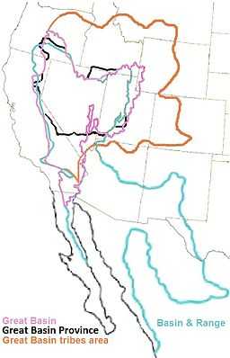
| Borders on | West: California Floristic Province; West, North, and East: Western Cordillera, Rocky Mountain Floristic Province; South: Mojave Basin and Range, Sonoran Basin and Range, and Arizona/New Mexico Mountains ecoregions; Sonoran Floristic Province. |
The Great Basin Province[2] is a floristic province of the Madrean Subkingdom (floristic region), in the Boreal Kingdom (floristic kingdom).[2] It is located in the Western United States.
It generally corresponds to the Central Basin and Range ecoregion and the Great Basin physiographic section.
The province includes xeric deserts — with < 10 in (250 mm) annual precipitation; and less xeric habitats — with > 10 in (250 mm) precipitation, access to aquifers, and/or in riparian zones.[3] Madrean Sky Islands are found at higher elevations, with montane habitats.
- Deserts
The larger deserts of the Great Basin Province are: the Great Basin Desert (39,505 square miles (102,320 km2) in Nevada; and the Great Salt Lake Desert (4,000 square miles (10,000 km2) and Escalante Desert (3,270 square miles (8,500 km2) in Utah.
See also
- Great Basin shrub steppe — Deserts and xeric shrublands biome ecoregion
- Great Basin montane forests — Temperate coniferous forest biome ecoregion''
- Central Basin and Range ecoregion — Level III ecoregion (EPA)
- Northern Basin and Range ecoregion — Level III ecoregion (EPA)
- Colorado Plateau — typically treated as a subprovince of the Great Basin Province as a floristic and ecoregion. Sometimes differentiated into the Colorado Plateau and the Kaibab Plateau, as in the EPA Level III classification.
References
- ↑ tbd. "Ecoregions of North America". USGS Western Ecology Division. Retrieved 2010-04-27.
- ↑ 2.0 2.1 Lentz, David L. (editor). Imperfect Balance: Landscape Transformations in the Precolumbian Americas. ISBN 0-231-11157-6. Retrieved 2010-09-06.
The southern border of the Great Basin Province is marked by the replacement of sagebrush by Larrea and Ambrosia (creosote bush and ragweed) … floras of arid regions [within the Madrean Subkingdom] are excluded and treated with either the Boreal Subkingdom (Great Basin Province) or with the Neotropical Kingdom (Mexican Xerophylic [Sonoran] Region). - ↑ Bryce, S.A; et. al, Ecoregions of Nevada, Reston, Virginia: USGS NOTE: The poster depicts the California northern point of the Mojave Basin & Range ecoregion at pixels 453 horizontal & 1151 vertical (interpolates to 37.28N,117.71W in the Last Chance Range, N of Sulfur Rd).