Great Basin
| Great Basin | |
| Countries | United States, Mexico |
|---|---|
| Location | GNIS-designated point in Sheep Ranch Canyon near Winnemucca, Nevada [1] |
| - coordinates | 40°40′N 117°40′W / 40.667°N 117.667°WCoordinates: 40°40′N 117°40′W / 40.667°N 117.667°W [1] |
| Highest point | Mount Whitney summit |
| - location | Sierra Nevada |
| - elevation | 14,505 ft (4,421.1 m) |
| - coordinates | 36°34′42.89″N 118°17′31.18″W / 36.5785806°N 118.2919944°W |
| Lowest point | Badwater Basin |
| - location | Death Valley |
| - elevation | -282 ft (-86 m) |
| - coordinates | 36°14′23″N 116°50′5″W / 36.23972°N 116.83472°W |
| Area | 184,427 sq mi (477,664 km2) [2] |
| - persistent water (average area) |
4,079 sq mi (10,565 km2) |
| Population | 3,163,941 |
| Orogeny | Basin and Range Province fault history |
| GNIS code | 2087988 [1] |
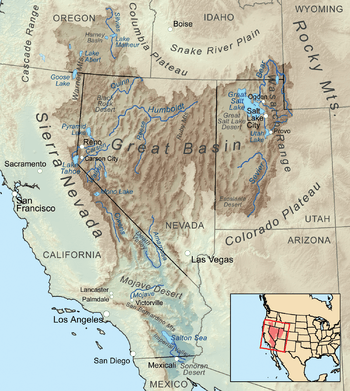 The Great Basin is the multi-state endorheic area surrounded by the Pacific Watershed of North America (Columbia Watershed on the north and the Colorado Watershed on the east and south).
| |
The Great Basin is the largest area of contiguous endorheic watersheds in North America. It is noted for both its arid climate and the Basin and range topography that varies from the North American low point at Badwater Basin to the highest point of the contiguous United States, less than 100 miles (160 km) away at the summit of Mount Whitney. The region spans several physiographic divisions, biomes/ecoregions, and deserts.
Geography
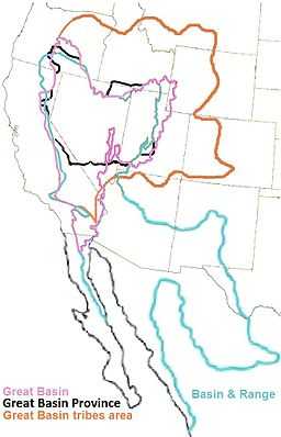
The Great Basin includes valleys, basins, lakes and mountain ranges of Basin and Range topography, with some in the phytogeographic Basin and Range Province.[3] The Great Basin almost entirely contains the smaller Great Basin physiographic section, which extends about 10,000 sq mi (26,000 km2) into the Colorado River watershed (including the Las Vegas metropolitan area and northwest corner of Arizona). Geographic features near the Great Basin include the Continental Divide of the Americas, the Great Divide Basin, and the Gulf of California.
Settlements and roads
The Great Basin's two most populous metropolitan areas are Reno to the west and Salt Lake City to the east. The area between these two cities is sparsely populated, but includes the smaller cities of Delta, Elko, Ely, Tonopah, Wendover, West Wendover, and Winnemucca.The Central Basin and Range has a mosaic of xeric basins. The southern area of the basin has the communities of Palmdale, Victorville, and Palm Springs. Major roadways traversing the Great Basin include Interstate 80, Interstate 15, U.S. Route 6, U.S. Route 50, U.S. Route 93, U.S. Route 95 and U.S. Route 395, with the Nevada section of U.S. Route 50 nicknamed "The Loneliest Road in America." [4] The Great Basin is traversed by several rail lines including the Union Pacific Railroad's Overland Route (Union Pacific Railroad) through Reno and Ogden, Feather River Route, Central Corridor and Los Angeles and Salt Lake Railroad. The Great Basin was once predominately inhabited by the Great Basin tribes.
Hydrology


The Great Basin Divide separates the Great Basin from the watersheds draining to the Pacific Ocean. The southernmost portion of the Great Basin is the watershed area of the Laguna Salada. The Great Basin's longest and largest river is the Bear River of 350 mi (560 km),[5] and the largest single watershed is the Humboldt River drainage of roughly 17,000 sq mi (44,000 km2). Most Great Basin precipitation is snow, and the precipitation that neither evaporates nor is extracted for human use will sink into groundwater aquifers, while evaporation of collected water occurs from geographic sinks.[6] Lake Tahoe, North America's largest alpine lake,[7] is part of the Great Basin's central Lahontan subregion. Great Basin named deserts include the Black Rock Desert, the Great Salt Lake Desert, the Sevier Desert, the Smoke Creek Desert, Nevada salt deserts in the Great Basin Province, the Mojave Desert, and part of the Sonoran Desert.

Ecology
Although mostly within the North American Desert ecoregion, portions of the Great Basin extend into the Forested Mountain and Mediterranean California ecoregions. The semi-arid areas of the Forested Mountain ecoregion include the White Mountains and Inyo Mountains. Extending north of the 42nd parallel north, the Northern Basin and Range (ecoregion) has its southern border at the highest shoreline of the Pleistocene Lake Bonneville. The south edge of the Central Basin and Range ecoregion is in Nevada, north of the south edge of the Great Basin section.
In phytogeography, the Great Basin is within the Great Basin (floristic) Province of the Madrean Region in southwestern North America. The floristic province and region are within the Holarctic Kingdom, of the northern Western Hemisphere..
Fauna
Great Basin wildlife includes pronghorn, mule deer, mountain lion, and lagomorphs such as black-tailed jackrabbit and desert cottontail and the coyotes that prey on them. Packrats, kangaroo rats and other small rodents are also common, but these are predominantly nocturnal. Elk and bighorn sheep are present but uncommon. Small lizards such as the Great Basin fence lizard, longnose leopard lizard and horned lizard are common, especially in lower elevations. Rattlesnakes and gopher snakes are also present. The Inyo Mountains salamander is endangered. Shorebirds such as phalaropes and curlews can be found in wet areas. American white pelicans are common at Pyramid Lake. Golden eagles are also very common in the Great Basin.[8] Mourning dove, western meadowlark, black-billed magpie, and common raven are other common bird species.
Two endangered species of fish are found in Pyramid Lake: the Cui-ui sucker fish (endangered 1967) and the Lahontan cutthroat trout (threatened 1970).[9]
Large invertebrates include tarantulas (Aphonopelma genus) and Mormon crickets. Exotic species, including chukar, grey partridge, and Himalayan snowcock, have been successfully introduced to the Great Basin, although the latter has only thrived in the Ruby Mountains. Cheatgrass, an invasive species which was unintentionally introduced, forms a critical portion of their diets. Feral horses (mustangs) and wild burros are other highly reproductive, and ecosystem-controversial, alien species. Most of the Great Basin is open range and domestic cattle and sheep are widespread.
Flora
Utah juniper/single-leaf pinyon (southern regions) and mountain mahogany (northern regions) form open pinyon-juniper woodland on the slopes of most ranges. Stands of limber pine and Great Basin bristlecone pine (Pinus longaeva) can be found in some of the higher ranges (the Methuselah tree is nearly 5000 years old). In riparian areas with dependable water cottonwoods (Populus fremontii) and quaking aspen (Populus tremuloides) groves exist. Grasslands contain the native Great Basin wildrye.
History

Sediment build-up over thousands of years filled the down-faulted basins between ranges and created relatively flat lacustrine plains from Pleistocene lake beds of the Great Basin.[10] For example, after forming about 32,000 years ago, Lake Bonneville overflowed about 14,500 years ago in the Bonneville Flood through Red Rock Pass and lowered to the "Provo Lake"[11] level (the Great Salt Lake, Utah Lake, Sevier Lake, Rush Lake, and Little Salt Lake remain).[12] Lake Lahontan, Lake Manly, and Lake Mojave were similar Pleistocene lakes.
Paleo-Indian habitation by the Great Basin tribes began as early as 10,000 B.C. (the Numic-speaking Shoshonean peoples arrived as late as 1000 A.D.).[13] Archaeological evidence of habitation sites along the shore of Lake Lahontan date from the end of the ice age when its shoreline was approximately 500 feet (150 m) higher along the sides of the surrounding mountains. The Great Basin was inhabited for at least several thousand years by Uto-Aztecan language group-speaking Native American Great Basin tribes, including the Shoshone, Ute, Mono, and Northern Paiute.
Exploration of the Great Basin occurred during the 18th century Spanish colonization of the Americas. The first American to cross the Great Basin from the Sierra Nevada was Jedediah Strong Smith in 1827. [14] Peter Skene Ogden of the British Hudson's Bay Company explored the Great Salt Lake and Humboldt River regions in the late 1820s, following the eastern side of the Sierra Nevada to the Gulf of California.[15] Benjamin Bonneville explored the northeast portion during an 1832 expedition. The United States had acquired control of the area north of the 42nd parallel via the 1819 Adams–Onís Treaty with Spain and 1846 Oregon Treaty with Britain. The US gained control of most of the rest of the Great Basin via the 1848 Mexican Cession. The first non-indigenous settlements were connected with the eastern regions of the 1848 California Gold Rush, with its immigrants crossing the Great Basin on the California Trail along Nevada's Humboldt River to Carson Pass in the Sierras. The first American religious settlement effort was the Mormon provisional State of Deseret in 1849 in present day Utah and northern Nevada. They started settling the Great Salt Lake Valley in 1847. The Oregon Territory was established in 1848 and the Utah Territory in 1850.
In 1869 the First Transcontinental Railroad was completed at Promontory Summit in the Great Basin.[16] Around 1902, the San Pedro, Los Angeles and Salt Lake Railroad was constructed in the lower basin and Mojave Desert for California-Nevada rail service to Las Vegas, Nevada.
To close a 1951 Indian Claims Commission case, the Western Shoshone Claims Distribution Act of 2004 established the United States payment of $117 million to the Great Basin tribe for the acquisition of 39,000 square miles (100,000 km2).[17] The Dixie Valley, Nevada, earthquake (6.6-7.1) in the Great Basin was in 1954. The Mojave and Colorado Deserts Biosphere Reserve (4 conserved areas) was designated in 1984, and in 1986, and 1994, the Great Basin National Park and the Mojave National Preserve were established. In 2009, the American Land Conservancy's Great Basin Program reserved the Green Gulch mule deer migration corridor as part of "over 80,000 acres [conserved] in Nevada and the Eastern Sierras".[18]
Climate
Climate varies throughout the Great Basin by elevation, latitude, and other factors. Higher elevations tend to be cooler and receive more precipitation. The western areas of the basin tend to be drier than the eastern areas because of the rain shadow of the Sierra Nevada. Most of the basin experiences a semi-arid or arid climate with warm summers and cold winters. However, some of the mountainous areas in the basin are high enough in elevation to experience an Alpine climate. Due to the region's altitude and aridity, most areas in the Great Basin experience a substantial Diurnal temperature variation.
The Great Basin National Park, located in a central part of the Great Basin, provides perhaps the best example of a typical climate for the region.
| Climate data for Great Basin National Park - Lehman Caves Visitor Center (elevation 6,840 feet (2,080 m)) | |||||||||||||
|---|---|---|---|---|---|---|---|---|---|---|---|---|---|
| Month | Jan | Feb | Mar | Apr | May | Jun | Jul | Aug | Sep | Oct | Nov | Dec | Year |
| Record high °F (°C) | 67 (19) |
66 (19) |
74 (23) |
81 (27) |
91 (33) |
97 (36) |
100 (38) |
96 (36) |
93 (34) |
83 (28) |
77 (25) |
67 (19) |
100 (38) |
| Average high °F (°C) | 40.5 (4.7) |
42.8 (6) |
48.7 (9.3) |
56.7 (13.7) |
66.5 (19.2) |
77.4 (25.2) |
85.7 (29.8) |
83.3 (28.5) |
74.5 (23.6) |
61.7 (16.5) |
48.4 (9.1) |
41.1 (5.1) |
60.6 (15.9) |
| Average low °F (°C) | 18.9 (−7.3) |
21.2 (−6) |
25.5 (−3.6) |
31.5 (−0.3) |
40.0 (4.4) |
49.0 (9.4) |
57.4 (14.1) |
55.8 (13.2) |
47.0 (8.3) |
37.1 (2.8) |
25.9 (−3.4) |
19.6 (−6.9) |
35.7 (2.1) |
| Record low °F (°C) | −20 (−29) |
−15 (−26) |
−2 (−19) |
0 (−18) |
6 (−14) |
14 (−10) |
32 (0) |
32 (0) |
10 (−12) |
6 (−14) |
−12 (−24) |
−19 (−28) |
−20 (−29) |
| Average precipitation inches (mm) | 1.05 (26.7) |
1.18 (30) |
1.37 (34.8) |
1.21 (30.7) |
1.24 (31.5) |
0.87 (22.1) |
0.97 (24.6) |
1.18 (30) |
1.08 (27.4) |
1.24 (31.5) |
0.97 (24.6) |
0.96 (24.4) |
13.33 (338.6) |
| Average snowfall inches (cm) | 12.8 (32.5) |
13.8 (35.1) |
13.2 (33.5) |
7.1 (18) |
2.1 (5.3) |
0.2 (0.5) |
0 (0) |
0 (0) |
0.2 (0.5) |
3.7 (9.4) |
8.7 (22.1) |
10.7 (27.2) |
72.6 (184.4) |
Fallon's climate is typical of lower elevations in the western part of the Great Basin. Located in the Forty Mile Desert, precipitation is rare, and summers are hot, though temperatures are more moderate than those in deserts like the Mojave and Sonoran, due to the region's higher elevation and latitude. Winters in this section of the basin are still cold, however.
| Climate data for Fallon, Nevada. (Elevation 3,960 feet (1,210 m)) | |||||||||||||
|---|---|---|---|---|---|---|---|---|---|---|---|---|---|
| Month | Jan | Feb | Mar | Apr | May | Jun | Jul | Aug | Sep | Oct | Nov | Dec | Year |
| Record high °F (°C) | 71 (22) |
78 (26) |
84 (29) |
90 (32) |
102 (39) |
106 (41) |
108 (42) |
105 (41) |
100 (38) |
92 (33) |
81 (27) |
72 (22) |
108 (42) |
| Average high °F (°C) | 44.3 (6.8) |
51.3 (10.7) |
58.9 (14.9) |
65.9 (18.8) |
73.9 (23.3) |
83.1 (28.4) |
92.2 (33.4) |
90.1 (32.3) |
81.1 (27.3) |
69.2 (20.7) |
55.4 (13) |
45.4 (7.4) |
67.6 (19.8) |
| Average low °F (°C) | 18.1 (−7.7) |
23.2 (−4.9) |
27.8 (−2.3) |
33.9 (1.1) |
41.4 (5.2) |
47.9 (8.8) |
54.0 (12.2) |
51.4 (10.8) |
43.2 (6.2) |
33.8 (1) |
24.8 (−4) |
18.9 (−7.3) |
34.9 (1.6) |
| Record low °F (°C) | −25 (−32) |
−27 (−33) |
1 (−17) |
13 (−11) |
20 (−7) |
27 (−3) |
35 (2) |
33 (1) |
21 (−6) |
12 (−11) |
0 (−18) |
−21 (−29) |
−27 (−33) |
| Average precipitation inches (mm) | 0.54 (13.7) |
0.54 (13.7) |
0.46 (11.7) |
0.51 (13) |
0.60 (15.2) |
0.43 (10.9) |
0.16 (4.1) |
0.22 (5.6) |
0.28 (7.1) |
0.41 (10.4) |
0.38 (9.7) |
0.48 (12.2) |
4.98 (126.5) |
| Average snowfall inches (cm) | 1.8 (4.6) |
0.9 (2.3) |
0.8 (2) |
0.2 (0.5) |
0.1 (0.3) |
0 (0) |
0 (0) |
0 (0) |
0 (0) |
0.1 (0.3) |
0.5 (1.3) |
1.3 (3.3) |
5.7 (14.5) |
| Source: The Western Regional Climate Center[19] | |||||||||||||
The Great Salt Lake Desert, located near the north-east corner of the Great Basin, is an excellent example of a cold desert climate. Although still arid, it is worthy to note that this portion of the Great Basin receives more precipitation than the similar playas and salt pans on the western edge of the Great Basin.
| Climate data for Knolls, Great Salt Lake Desert, Utah. (Elevation 4,250 feet (1,300 m)) | |||||||||||||
|---|---|---|---|---|---|---|---|---|---|---|---|---|---|
| Month | Jan | Feb | Mar | Apr | May | Jun | Jul | Aug | Sep | Oct | Nov | Dec | Year |
| Record high °F (°C) | 63 (17) |
63 (17) |
79 (26) |
87 (31) |
98 (37) |
104 (40) |
106 (41) |
103 (39) |
99 (37) |
89 (32) |
71 (22) |
66 (19) |
106 (41) |
| Average high °F (°C) | 36.5 (2.5) |
41.4 (5.2) |
54.4 (12.4) |
62.3 (16.8) |
72.3 (22.4) |
83.5 (28.6) |
92.8 (33.8) |
90.9 (32.7) |
80.0 (26.7) |
64.3 (17.9) |
46.5 (8.1) |
36.5 (2.5) |
63.4 (17.4) |
| Average low °F (°C) | 16.9 (−8.4) |
19.3 (−7.1) |
29.1 (−1.6) |
36.6 (2.6) |
44.9 (7.2) |
54.7 (12.6) |
62.1 (16.7) |
59.5 (15.3) |
48.0 (8.9) |
34.4 (1.3) |
23.3 (−4.8) |
14.5 (−9.7) |
37.0 (2.8) |
| Record low °F (°C) | −16 (−27) |
−17 (−27) |
−1 (−18) |
14 (−10) |
24 (−4) |
35 (2) |
43 (6) |
39 (4) |
25 (−4) |
8 (−13) |
−3 (−19) |
−25 (−32) |
−25 (−32) |
| Average precipitation inches (mm) | 0.61 (15.5) |
0.46 (11.7) |
0.91 (23.1) |
1.01 (25.7) |
1.23 (31.2) |
0.68 (17.3) |
0.36 (9.1) |
0.31 (7.9) |
0.56 (14.2) |
0.77 (19.6) |
0.61 (15.5) |
0.38 (9.7) |
7.88 (200.2) |
| Average snowfall inches (cm) | 0.3 (0.8) |
0.1 (0.3) |
0 (0) |
0 (0) |
0 (0) |
0 (0) |
0 (0) |
0 (0) |
0 (0) |
0 (0) |
0 (0) |
0.1 (0.3) |
0.5 (1.3) |
| Source: The Western Regional Climate Center[19] | |||||||||||||
See also
- Hidden Cave, an archaeological cave site located in the Great Basin
- River basins in the United States
References
- ↑ 1.0 1.1 1.2 "Great Basin (2087988)". Geographic Names Information System. United States Geological Survey. Retrieved 2011-10-01.
- ↑ "Boundary Descriptions and Names of Regions, Subregions, Accounting Units and Cataloging Units". U.S. Geological Survey. Retrieved 2010-10-23.
- ↑ "Basin and Range Province". Geologic Provinces of the United States. United States Geological Survey. 2004. Retrieved 2009-01-10.
- ↑ "The Official Hwy 50 Survival Guide — The Loneliest Road in America" (PDF). Nevada Commission on Tourism. Retrieved 2007-12-15.
- ↑ "Bear River Watershed Description". Bear River Watershed Information System. Retrieved 2010-04-28. (an additional ~1% is in the SW corner of WY)
- ↑ "Great Basin". Geologic Provinces of the United States: Basin and Range Province. nature.nps.gov: National Park Service. Retrieved 2009-01-10.
- ↑ "Amazing Lake Tahoe". Lake Tahoe Visitors Authority. Retrieved 2008-10-26.
- ↑ http://ethnobiology.org/sites/default/files/pdfs/JoE/15-2/Schmitt1995.pdf
- ↑ Hogan, C.Michael; Papineau, Marc, et al (1987). Development of a dynamic water quality simulation model for the Truckee River. Environmental Protection Agency Technology Series. Washington D.C.: Earth Metrics Inc.
- ↑ Jackson, Richard H.; Stevens, Dale J. (1981). "Physical and Cultural Environment of Utah Lake and Adjacent Areas". Great Basin Naturalist Memoirs (5: Utah Lake Monograph): 5. Retrieved 2010-04-06.
- ↑ Gilbert, Grove Karl (1890). Lake Bonneville (GOOGLE BOOKS). p. 127. Retrieved 2010-04-23.
- ↑ Morgan, Dale L (1947). The Great Salt Lake. Salt Lake City: University of Utah Press. p. 22. ISBN 0-87480-478-7.
- ↑ "Archaeology, Cultural Transmission, and the Indigenous Native American Indians of the Great Basin Region of North America". Bauu Institute. Retrieved 2010-04-22.
- ↑ Morgan (1953, 1964), Jedediah Smith and the Opening of the West, p. 7
- ↑ Ogden, Peter Skene, Dictionary of Canadian Biography Online
- ↑ "Ceremony at "Wedding of the Rails," May 10, 1869 at Promontory Point, Utah". World Digital Library. 1869-05-10. Retrieved 2013-07-20.
- ↑ "Action Alert!". Shundahai Network. Retrieved 2010-04-22.
- ↑ "Great Basin". Programs. American Land Conservancy. Retrieved 2010-01-11.
- ↑ 19.0 19.1 "Seasonal Temperature and Precipitation Information". Western Regional Climate Center. Retrieved April 1, 2013.
External links
| Wikimedia Commons has media related to Great Basin (USA). |
- "Great Basin" from the Utah History Encyclopedia by Gary B. Peterson
| Wikisource has the text of the 1920 Encyclopedia Americana article Great Basin. |
| ||||||||