Great Alpine Road
| Great Alpine Road Victoria | |
|---|---|
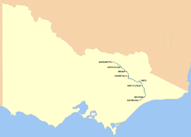 | |
| Map of the Great Alpine Road in eastern Victoria | |
| General information | |
| Type | Highway |
| Length | 303 km (188 mi) |
| Opened | 1998 |
| Route number(s) |
|
| Former route number |
|
| Major junctions | |
| NW end |
|
| |
| SE end |
|
| Location(s) | |
| Major settlements | Myrtleford, Ovens, Bright, Harrietville, Mount Hotham, Dinner Plain, Omeo, Swifts Creek, Ensay, Bruthen |
| Highway system | |
|
Highways in Australia National Highway • Freeways in Australia Highways in Victoria | |
The Great Alpine Road (B500)[1][2][3] is a country tourist road in Victoria, Australia, running from Wangaratta in the north to Bairnsdale in the east, and passing through the Victorian Alps. The road was given its current name because it was considered the mountain equivalent to Victoria's world famous Great Ocean Road in the south-west of the state.
Route details
The Great Alpine Road[4] winds through mountains, valleys and forests, and past rivers, vineyards and farms. At a length of 303 kilometres (188 mi), it is Australia's highest year-round accessible sealed road. The section over Mount Hotham rises to an altitude of 1,840 metres (6,040 ft) AMSL.[5] It is blanketed with snow during winter months and must be cleared on a daily basis. Extreme weather conditions can sometimes still result in the road being closed between Harrietville and Omeo.
The Great Alpine Road links Victoria's North East with Gippsland. It was completed with the sealing of the section between Mount Hotham and Dinner Plain and was officially opened on 4 April 1998. The road itself has existed since colonial times in some form, but was unsealed for much of its history, and was only given the Great Alpine Road designation after being fully sealed.
The current Great Alpine Road includes the former Ovens Highway from Wangaratta to Bright, and a former section of the Omeo Highway from Omeo to Bruthen,[6] along with the section of the Princes Highway from Bruthen to Bairnsdale. Attractions include the Mount Buffalo National Park, the popular tourist town of Bright, the Mount Hotham and Dinner Plain alpine resorts, the historic gold rush township of Omeo, the folk art sculpture Mr. Stringy, and stunning views and challenging driving along its length.
Also in the region is the 3,600 hectares (8,900 acres) Cassilis historic area. Once a thriving mining town, it contains gold-mining relics and a lonely cemetery.[7]
Gallery of some notable sights
-
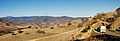
The Great Alpine Road descending "The Gap" between Omeo and Swifts Creek.
-
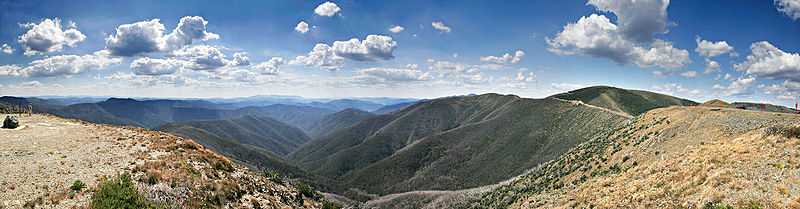
The Australian Alps from the Great Alpine Road on Mount Hotham.
-

View from Myrtleford to Mount Buffalo National Park.
-
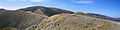
The Great Alpine Road winds across Mount Hotham, clinging to the side and ridge of the mountain
Major Intersections, Towns and Resorts
| Great Alpine Road | |||
| Northbound | Distance to Wangaratta (km) |
Distance to Bairnsdale (km) |
Southbound |
| Parfitt Road Parfitt Road | |||
| End Great Alpine Road |
1 | 306 | Start Great Alpine Road |
| Wodonga, Sydney Hume Freeway |
5 | 302 | Wodonga, Sydney Hume Freeway |
| Seymour, Melbourne Hume Freeway |
6 | 301 | Seymour, Melbourne Hume Freeway |
| Beechworth, Yackandandah Beechworth-Wangaratta Road |
12 | 295 | Beechworth, Yackandandah Beechworth-Wangaratta Road |
| Beechworth Buckland Road |
35 | 272 | Beechworth Buckland Road |
| Milawa, Glenrowan Snow Road |
41 | 266 | Milawa, Glenrowan Snow Road |
| Yackandandah Myrtleford-Yackandandah Road |
46 | 261 | Yackandandah Myrtleford-Yackandandah Road |
| Myrtleford | |||
| Lake Buffalo Buffalo River Road |
47 | 260 | Lake Buffalo Buffalo River Road |
| Myrtleford | |||
| Ovens | 51 | 256 | Ovens |
| Mount Beauty Happy Valley Road |
Mount Beauty Happy Valley Road | ||
| Porepunkah | 70 | 237 | Porepunkah |
| Mount Buffalo Mount Buffalo Road |
71 | 236 | Mount Buffalo Mount Buffalo Road |
| Bright | 77 | 230 | Bright |
| Mount Beauty Tawonga Gap Road |
83 | 224 | Mount Beauty Tawonga Gap Road |
| Harrietville | 101 | 206 | Harrietville |
| Mount Hotham | 132 | 175 | Mount Hotham |
| Dinner Plain | 143 | 164 | Dinner Plain |
| Omeo | 186 | 121 | Omeo |
| Benambra, Tallangatta Omeo Highway |
187 | 120 | Benambra, Tallangatta Omeo Highway |
| Swifts Creek | 213 | 94 | Swifts Creek |
| Ensay | 231 | 76 | Ensay |
| Bruthen | 282 | 25 | Buchan, Orbost Bruthen-Buchan Road |
| Buchan, Orbost Bruthen-Buchan Road |
Bruthen | ||
| Swan Reach Sarsfield-Tambo Upper Road |
286 | 21 | Swan Reach Sarsfield-Tambo Upper Road |
| Start Great Alpine Road |
305 | 2 | End Great Alpine Road |
| Princes Highway Princes Highway | |||
See also
- Highways in Australia
- Highways in Victoria
| Wikimedia Commons has media related to Great Alpine Road. |
References
- ↑ "Map NE Victoria". vic roads. p. p16. Retrieved 09/02/2009. Check date values in:
|accessdate=(help) size 2.4MB - ↑ "Google Maps". 2009 Google – Map data 2009 MapData Sciences Pty Ltd, PSMA. Retrieved 10/02/2009. Check date values in:
|accessdate=(help) - ↑ State Route 156 – Ovens Highway, Main Roads Victoria. Retrieved on 23 September 2013.
- ↑ "Great Alpine Road". Tourism Victoria. Retrieved 10/02/2009. Check date values in:
|accessdate=(help) - ↑ "Mt Hotham Section". 2009 Google – Map data 2009 MapData Sciences Pty Ltd, PSMA. Retrieved 10/02/2009. Check date values in:
|accessdate=(help) - ↑ 8423 Omeo, Victoria, Topographic Map. National Topographic Map Series (1 ed.). Commonwealth of Australia. 1982.
- ↑ "Great Alpine Road". Discover East Gippsland. Retrieved 30 September 2013.
External links
"Great Alpine Road – Tourism Victoria". Retrieved 21 July 2011.
"Australian Traveller". Retrieved 10/02/2009. Check date values in: |accessdate= (help)
"Sydney – Melbourne Touring". Retrieved 10/02/2009. Check date values in: |accessdate= (help)
"Victoria's Alpine High Country". Retrieved 10/02/2009. Check date values in: |accessdate= (help)
"NRMA Motoring Services". Retrieved 10/02/2009. Check date values in: |accessdate= (help)
"Discover East Gippsland". Retrieved 10/02/2009. Check date values in: |accessdate= (help)
| ||||||||||||||||||||