Grave Creek (Oregon)
| Grave Creek | |
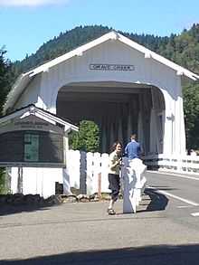
.jpg) The covered bridge over Grave Creek on Sunny Valley Loop Road | |
| Name origin: The grave of a child, Martha Leland Crowley, who died near the creek in 1846[1] | |
| Country | United States |
|---|---|
| State | Oregon |
| County | Douglas, Jackson, and Josephine |
| Source | Cedar Springs Mountain |
| - location | Klamath Mountains, Douglas County, Oregon |
| - elevation | 4,556 ft (1,389 m) [2] |
| - coordinates | 42°45′26″N 123°07′41″W / 42.75722°N 123.12806°W [3] |
| Mouth | Rogue River |
| - location | about 5 miles (8.0 km) north of Galice, Josephine County, Oregon |
| - elevation | 623 ft (190 m) [3] |
| - coordinates | 42°38′54″N 123°35′05″W / 42.64833°N 123.58472°WCoordinates: 42°38′54″N 123°35′05″W / 42.64833°N 123.58472°W [3] |
| Basin | 163 sq mi (422 km2) [4] |
| Discharge | for near Placer |
| - average | 132 cu ft/s (4 m3/s) [4][5] |
| - max | 8,000 cu ft/s (227 m3/s) |
| - min | 1 cu ft/s (0 m3/s) |
 Location of the mouth of Grave Creek in Oregon
| |
Grave Creek is a tributary, about 30 miles (48 km) long, of the Rogue River in southwestern Oregon in the United States. The creek begins near Cedar Springs Mountain just north of the Douglas County – Jackson County border and flows generally southwest through Jackson County and Josephine County to its confluence with the Rogue.[6] Wolf Creek and Sunny Valley are the main communities along the creek. Major tributaries include Reuben, Poorman, Wolf, and Rock creeks.[4]
Outdoor activities
Hiking trails and river runs converge at the confluence of Grave Creek and the Rogue River. Boaters sometimes run the lower 6 miles (10 km) of Grave Creek when its flow is 500 to 1,000 cubic feet per second (14 to 28 m3/s).[7] The run, rated class 3 on the International Scale of River Difficulty, has "short twisting blind drops on the section not visible from the road"[7] and possible hazards that include low-hanging footbridges as well as brush along the stream banks. A handy stopping place for this run is the boat ramp near the Grave Creek Bridge over the Rogue River.[7] The ramp is also popular with rafters and kayakers running the 40-mile (64 km) "wild" stretch of the Wild and Scenic lower Rogue, which begins at the mouth of Grave Creek.[8] It is "one of the best-known whitewater runs in the United States."[9] Parallel to the wild stretch of the river, the Lower Rogue River Trail winds through the Wild Rogue Wilderness between the mouth of Grave Creek and Illahe.[8]
References
- ↑ McArthur, Lewis A.; McArthur, Lewis L. (2003). Oregon Geographic Names (Seventh ed.). Portland, Oregon: Oregon Historical Society Press. pp. 424–25. ISBN 0-87595-277-1.
- ↑ Source elevation derived from Google Earth search using Geographic Names Information System (GNIS) source coordinates.
- ↑ 3.0 3.1 3.2 "Grave Creek". Geographic Names Information System. United States Geological Survey. November 28, 1980. Retrieved June 1, 2009.
- ↑ 4.0 4.1 4.2 "Grave Creek Water Quality Restoration Plan 2001" (PDF). Bureau of Land Management, Medford District Office. Retrieved June 3, 2009.
- ↑ "USGS 14372000 Grave Creek near Placer, Oregon". United States Geological Survey (USGS). Retrieved June 3, 2009.The average flow was derived by adding the average annual flows from this discontinued gauge for the years 1951–54 and dividing by 4.
- ↑ Oregon Atlas and Gazetteer (Map) (1991 ed.). DeLorme Mapping. § 26–27. ISBN 0-89933-235-8.
- ↑ 7.0 7.1 7.2 Giordano, p. 117
- ↑ 8.0 8.1 Sullivan, pp. 187–93
- ↑ Giordano, p. 120
External links
Works cited
- Giordano, Pete (2004). Soggy Sneakers: A Paddler's Guide to Oregon's Rivers, fourth edition. Seattle: The Mountaineers Books. ISBN 978-0-89886-815-9.
- Sullivan, William L. (2002). Exploring Oregon's Wild Areas, third edition. Seattle: The Mountaineers Press. ISBN 0-89886-793-2.