Grantville, Kansas
| Grantville, Kansas | |
|---|---|
| census-designated place | |
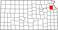
 Location of Grantville in Kansas | |
| Coordinates: 39°05′00″N 95°33′41″W / 39.08333°N 95.56139°WCoordinates: 39°05′00″N 95°33′41″W / 39.08333°N 95.56139°W | |
| Country | United States |
| State | Kansas |
| County | Jefferson |
| Elevation[1] | 876 ft (267 m) |
| Time zone | Central (CST) (UTC-6) |
| • Summer (DST) | CDT (UTC-5) |
| ZIP code | 66429 |
| Area code(s) | 785 |
| FIPS code | 20-20087 |
| GNIS feature ID | 478665[1] |
| Other name | Kaw City[1] |
| [2] | |
Grantville is an unincorporated census-designated place in southwestern Jefferson County, Kansas, United States, northeast of Topeka.
History
Grantville was named in 1866 for Ulysses S. Grant, military commander in the Civil War and afterward 18th President of the United States.[3]
The first post office in Grantville was established in October 1866.[4]
Geography
Grantville is located at 39°05′00″N 95°33′41″W / 39.083333°N 95.561367°W (39.083333, -95.561367),[1] off U.S. Route 24. It lies 876 feet (267 m) above sea level.
Climate
The climate in this area is characterized by hot, humid summers and generally mild to cool winters. According to the Köppen Climate Classification system, Grantville has a humid subtropical climate, abbreviated "Cfa" on climate maps.[5]
Economy
Grantville has a fire station, a restaurant, a gas station and a few other local business. It also has a post office with the ZIP Code of 66429.[2]
Education
Grantville is served by Perry-Lecompton Unified School District 343. An early childhood center is located in Grantville.[6]
Notable people
- Josh Billings, baseball player and manager
References
- ↑ 1.0 1.1 1.2 1.3 U.S. Geological Survey Geographic Names Information System: Grantville, Kansas. Retrieved on 2008-06-07.
- ↑ 2.0 2.1 ZIP Code Lookup. Retrieved on 2008-06-07.
- ↑ Heim, Michael (2007). Exploring Kansas Highways. p. 48.
- ↑ "Kansas Post Offices, 1828-1961 (archived)". Kansas Historical Society. Retrieved 11 June 2014.
- ↑ Climate Summary for Grantville, Kansas
- ↑ Grantville Early Childhood Center. Perry-Lecompton USD 343. Retrieved on 2008-06-07.
| |||||||||||||||||||||||||