Grant, Idaho
| Grant, Idaho | |
|---|---|
| Unincorporated community | |
|
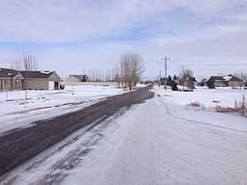
E 100 N or "Farm to Market Road" in Grant, Idaho | |
 Grant, Idaho | |
| Coordinates: 43°38′28″N 112°0′47″W / 43.64111°N 112.01306°WCoordinates: 43°38′28″N 112°0′47″W / 43.64111°N 112.01306°W | |
| Country | United States |
| State | Idaho |
| County | Jefferson |
| Elevation | 4,790 ft (1,460 m) |
| Time zone | Mountain (MST) (UTC-7) |
| • Summer (DST) | MDT (UTC-6) |
| ZIP code | 83442 |
| Area code(s) | 208 |
| GNIS feature ID | 372901[1] |
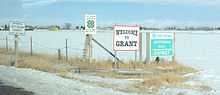
Entering Grant, Idaho on Lewisville Highway, northbound
Grant is an unincorporated community in Jefferson County, Idaho, United States. Grant is 5.3 miles (8.5 km) west-southwest of Rigby.[2] and 12.1 miles (19.5 km) north of Idaho Falls.
Grant is a rural community close to the Snake River. It is home to Central Cemetery, which serves the community of Garfield as well as Grant in Jefferson County.[3]
Grant has been known historically as Poverty Flats and Gravy Bend - names that were acquired during impoverished times when residents had to eat watered-down gravy.[4]
References
- ↑ U.S. Geological Survey Geographic Names Information System: Grant, Idaho
- ↑ "Populated Place Profile, ID Home Town Locator". Retrieved 2 January 2014.
- ↑ "Grant-Central Cemetery". http://grantcentralcemetery.org/''. Retrieved 23 June 2014.
- ↑ "GNIS Detail Page for Grant, ID". Retrieved 2 January 2014.
| |||||||||||||||||||||