Grandes Jorasses
| Grandes Jorasses | |
|---|---|
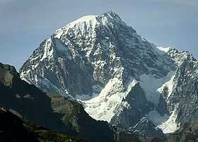
 North face of the Grandes Jorasses and the Leschaux Glacier (September 2000) | |
| Elevation | 4,208 m (13,806 ft) |
| Prominence | 841 m (2,759 ft) |
| Location | |
 Grandes Jorasses | |
| Range | Graian Alps |
| Coordinates | 45°52′08″N 6°59′17″E / 45.86889°N 6.98806°ECoordinates: 45°52′08″N 6°59′17″E / 45.86889°N 6.98806°E |
| Geology | |
| Type | Granite |
| Climbing | |
| First ascent | Horace Walker, Melchior Anderegg, Johann Jaun and Julien Grange, 30 June 1868 |
| Easiest route | Pointe Walker, south-west face, AD-, II, 1,400 m (4,600 ft), to 45 degrees - a glacier climb |
The Grandes Jorasses (4,208 m; 13,806 ft) is a mountain in the Mont Blanc massif.
The first ascent of the highest peak of the mountain (Pointe Walker) was by Horace Walker with guides Melchior Anderegg, Johann Jaun and Julien Grange on 30 June 1868. The second-highest peak on the mountain (Pointe Whymper, 4,184 m; 13,727 ft) was first climbed by Edward Whymper, Christian Almer, Michel Croz and Franz Biner on June 24, 1865, using what has become the normal route of ascent and the one followed by Walker's party in 1868.
The summits on the mountain are the following:
- Pointe Croz (4,110 m; 13,484 ft) – named after Michel Croz, a guide from Chamonix
- Pointe Elena (4,045 m; 13,271 ft) – named after Princess Elena of Savoy
- Pointe Margherita (4,065 m; 13,337) – named after Queen Margherita of Savoy, wife of King Umberto I of Italy
- Pointe Walker (4,208 m; 13,806 ft) – named after Horace Walker, who made the first ascent of the mountain
- Pointe Whymper (4,184 m; 13,727 ft) – named after Edward Whymper, who made the first ascent of this, the second-highest summit
- Pointe Young (3,996 m; 13,110 ft) – named after Geoffrey Winthrop Young

North face
Located on the French side of the mountain, the north face is one of the three great north faces of the Alps, along with the north faces of the Eiger and the Matterhorn (known as 'the Trilogy'). One of the most famous walls in the Alps, it towers 1200 m (3,900 ft) above the Leschaux Glacier, stretching 1 km from end to end. The classic route on the face is the Walker Spur (Cassin/Esposito/Tizzoni, 1938, TD+/ED1, IV, 5c/6a, A1, 1200 m) which leads directly to the summit of Pointe Walker. The other major buttress on the mountain is the Croz Spur, which leads to the summit of Pointe Croz. In her solo ascents of the six most difficult north faces of the Alps, Alison Hargreaves chose this route in preference to the Walker Spur.
South face
On the Italian side of the mountain, the south face can be accessed from the Boccalatte cabin, above the hamlet of Planpincieux in the Italian Val Ferret, part of the Courmayeur municipality.
Summit ridge
The summit ridge links Pt. Walker to the Col des Grandes Jorasses. It lies along the French-Italian border and is almost all above 4000 m (13,000 ft). There is a bivouac hut at the high snow saddle of the Col.
References
- Dumler, Helmut and Willi P. Burkhardt, The High Mountains of the Alps, London: Diadem, 1994
External links
- "Grandes Jorasses". SummitPost.org.