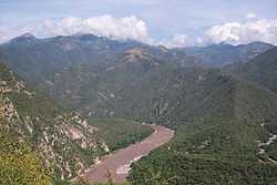
Grande de Santiago River
| Río Grande de Santiago | |
|---|---|
 | |
| Origin | Lake Chapala |
| Mouth | Pacific Ocean at San Blas / Santiago Ixcuintla, Nayarit |
| Basin countries |
|
| Length | 433 km (269 mi) |
| Avg. discharge |
Average: 320 cubic metres per second (11,000 cu ft/s) [1] |
| Basin area | 136,628 square kilometres (52,752 sq mi)[2] |
The Río Grande de Santiago is one of the longest rivers in Mexico, measuring up 433 km (269 mi) long. The river begins at Lake Chapala and continues roughly north-west through the Sierra Madre Occidental, receiving the Verde, Juchipila, Bolaños, and other tributaries. At La Yesca, the La Yesca Dam was completed in 2012 and the El Cajón Dam was completed downstream in 2007. Below El Cajón, the Aguamilpa Dam was completed in 1993, creating a reservoir covering a large part of the territory of the municipality of El Nayar in Nayarit. From Aguamilpa, the river descends to the coastal lowlands, passing by Santiago Ixcuintla and empties into the Pacific Ocean, 16 km (10 mi) northwest of San Blas, in Nayarit. The river is viewed by some sources as a continuation of the Lerma River, which flows into Lake Chapala.
See also
References
- ↑ "Santiago Discharge near El Capomal". River Discharge Database. Center for Sustainability and the Global Environment. 1965–1981. Retrieved 2010-05-30.
- ↑ "Rio Grande de Santiago Watershed". Watersheds of the World: North and Central America. World Resources Institute – EarthTrends. 2006. Retrieved 2010-05-30.
External links
Coordinates: 21°36′N 105°26′W / 21.600°N 105.433°W