Grand Muveran
| Grand Muveran | |
|---|---|
|
The Grand Muveran seen from near Aigle (northwest side) | |
| Elevation | 3,051 m (10,010 ft) |
| Prominence | 1,013 m (3,323 ft)[1] |
| Isolation | 8.7 km (5.4 mi)[2] |
| Parent peak | Finsteraarhorn |
| Location | |
 Grand Muveran Location in Switzerland | |
| Location | Valais/Vaud, Switzerland |
| Range | Bernese Alps |
| Coordinates | 46°14′14″N 7°07′34″E / 46.23722°N 7.12611°ECoordinates: 46°14′14″N 7°07′34″E / 46.23722°N 7.12611°E |
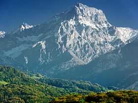
The Grand Muveran is a mountain of the Bernese Alps, located on the boder between the cantons of Vaud and Valais. At 3,051 metres, it is the highest summit of the group lying between the Rhone knee and the Pas de Cheville and the westernmost three-thousander of the Bernese Alps. The closest localities are Les Plans-sur-Bex (municipality of Bex, Vaud) and Ovronnaz (Valais). It is accompanied by the smaller peak of Petit Muveran.
Overlooking the Rhone valley from a height of about 2,600 metres, the Grand Muveran is the high point of a group (referred to as the Muverans) composed of several summits approaching 3,000 metres. To the southwest is the Dent de Morcles and the Dent Favre. To the northeast is the Tête à Pierre Grept and the Haut de Cry. The Muverans are the second highest massif of the canton of Vaud, after the Diablerets.
The normal route to the summit starts from the Rambert Hut (2,582 m), above Ovronnaz.
References
- ↑ Retrieved from the Swisstopo topographic maps. The key col is the Pas de Cheville (2,038 m).
- ↑ Retrieved from Google Earth. The nearest point of higher elevation is southwest of the Diablerets.
External links
![]() Media related to Grand Muveran at Wikimedia Commons
Media related to Grand Muveran at Wikimedia Commons