Grand Mound, Washington
| Grand Mound | |
|---|---|
| CDP | |
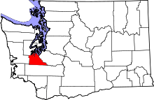
 Location of Grand Mound, Washington | |
| Coordinates: 46°48′14″N 123°0′36″W / 46.80389°N 123.01000°WCoordinates: 46°48′14″N 123°0′36″W / 46.80389°N 123.01000°W | |
| Country | United States |
| State | Washington |
| County | Thurston |
| Settled | 1851 |
| Area | |
| • Total | 3.93 sq mi (10.2 km2) |
| • Land | 3.93 sq mi (10.2 km2) |
| • Water | 0.0 sq mi (0 km2) |
| Elevation | 167 ft (51 m) |
| Population (2010) | |
| • Total | 2,981 |
| • Density | 759.3/sq mi (293.2/km2) |
| Time zone | Pacific (PST) (UTC-8) |
| • Summer (DST) | PDT (UTC-7) |
| FIPS code | 53-27890[1] |
| GNIS feature ID | 1512250[2] |
| Elevation[3] | |
Grand Mound is a community and census-designated place (CDP) in Thurston County, Washington, United States.[3] It was named and founded by Jotham Weeks Judson, father of Phoebe Judson, in 1851.[4] The population was 2,981 at the 2010 census. This area uses the 98579 zip code, which also includes Rochester and Gate.
History
Founded in 1851, stage service arrived in 1854.[5] In 1913, the Washington State School for Girls (also known as the State Training School for Girls) was created, and it opened at Ground Mound on 70 acres (28 ha) in 1914.[6][7][8] The school was renamed to Maple Lane School in 1959, and closed in 2011.[7][9]
In the 1920s strawberries became a major crop in the area, and a processing plant was built, but during the Great Depression the industry failed and the Northern Pacific Railway closed the Grand Mound station.[5] By 1941 the population of the area had grown to about 200 people and the community had a post office along with a store and a single gas station.[8] In 1964, the Grand Mound Fire District was formed, which in 2002 merged with Thurston County Fire District #1 before merging into the West Thurston Regional Fire Authority.[10] The community became a census-designated place in 1990.[11] A new fire station was built to serve Grand Mound in 2007.[12] In March 2008, a 398-room Great Wolf Lodge opened in Grand Mound, which was majority owned by the Confederated Tribes of the Chehalis Reservation.[13][14]
Geography
Grand Mound is located at 46°48′14″N 123°00′36″W / 46.803808°N 123.009964°W (46.803808, -123.009964).[15] It is in the southern part of Thurston County, near the county line with Lewis County, immediately north of Centralia. Interstate 5 and U.S. Route 12 serve the community, with the latter leaving Interstate 5 at the Grand Mound exit to head west to Grays Harbor. According to the United States Census Bureau, the CDP has a total area of 3.93 square miles (10.2 km2), all of it land. It is located on Ground Mound Prairie, which was named after a 125-foot (38 m) tree covered hill in the area, which was the largest of several similar mounds in the area.[8]
Government
Fire and emergency services are provided by the West Thurston Regional Fire Authority, with a single station located along Sargent Road.[12]
Demographics
| Historical population | |||
|---|---|---|---|
| Census | Pop. | %± | |
| 1990 | 1,394 | — | |
| 2000 | 1,948 | 39.7% | |
| 2010 | 2,981 | 53.0% | |
| source:[11] | |||
As of the census[1] of 2000, there were 1,948 people, 687 households, and 529 families residing in the CDP. The population density was 621.2 people per square mile (239.5/km2). There were 734 housing units at an average density of 234.1/sq mi (90.3/km2). The racial makeup of the CDP was 87.99% White, 0.31% African American, 1.23% Native American, 0.31% Asian, 0.10% Pacific Islander, 6.62% from other races, and 3.44% from two or more races. Hispanic or Latino of any race were 10.16% of the population.
There were 687 households out of which 38.0% had children under the age of 18 living with them, 57.2% were married couples living together, 12.7% had a female householder with no husband present, and 22.9% were non-families. 16.7% of all households were made up of individuals and 5.4% had someone living alone who was 65 years of age or older. The average household size was 2.84 and the average family size was 3.13.
In the CDP the age distribution of the population shows 29.1% under the age of 18, 9.7% from 18 to 24, 30.9% from 25 to 44, 21.2% from 45 to 64, and 9.1% who were 65 years of age or older. The median age was 33 years. For every 100 females there were 104.6 males. For every 100 females age 18 and over, there were 102.8 males.
The median income for a household in the CDP was $42,153, and the median income for a family was $41,864. Males had a median income of $40,250 versus $24,511 for females. The per capita income for the CDP was $16,008. About 13.5% of families and 14.8% of the population were below the poverty line, including 18.6% of those under age 18 and 12.5% of those age 65 or over.
See also
References
- ↑ 1.0 1.1 "American FactFinder". United States Census Bureau. Retrieved 2008-01-31.
- ↑ "US Board on Geographic Names". United States Geological Survey. 2007-10-25. Retrieved 2008-01-31.
- ↑ 3.0 3.1 "Grand Mound, Washington". Geographic Names Information System. United States Geological Survey. Retrieved 2014-05-19.
- ↑ Judson, Phoebe Goodell (1984) [1925]. A Pioneer's Search for an Ideal Home: A Book of Personal Memoirs. Lincoln, Nebraska: University of Nebraska Press. p. 86. ISBN 0-8032-2563-6.
- ↑ 5.0 5.1 Kirk, Ruth (1995). Exploring Washington's Past: A Road Guide to History. University of Washington Press. pp. 352–353.
- ↑ Ott, Jen (July 2, 2008). "Washington State Reform School opens in Chehalis on June 10, 1891.". HistoryLink.org. Retrieved 20 April 2014.
- ↑ 7.0 7.1 Kaelber, Lutz. "Washington". Eugenics: Compulsory Sterilization in 50 American States. University of Vermont. Retrieved 20 April 2014.
- ↑ 8.0 8.1 8.2 Federal Writers' Project, ed. (1941). The New Washington: A Guide to the Evergreen State. Metropolitan Press. pp. 489–490.
- ↑ Shannon, Brad (April 7, 2011). "Shelton, Grand Mound finalists for new prison unit". The Olympian. Retrieved 20 April 2014.
- ↑ "History". About Us. West Thurston Regional Fire Authority. Retrieved 20 April 2014.
- ↑ 11.0 11.1 "CENSUS OF POPULATION AND HOUSING (1790-2000)". U.S. Census Bureau. Retrieved 2010-07-31.
- ↑ 12.0 12.1 "Stations". West Thurston Regional Fire Authority. Retrieved 20 April 2014.
- ↑ Adams, Barry (May 4, 2009). "Great Wolf Resorts selling its share in two properties". The Wisconsin State Journal (Madison, WI).
- ↑ Adams, Barry (August 6, 2008). "Great Wolf reports $4.1 million quarterly loss". The Wisconsin State Journal (Madison, WI).
- ↑ "US Gazetteer files: 2010, 2000, and 1990". United States Census Bureau. 2011-02-12. Retrieved 2011-04-23.
| |||||||||||||||||||||||||||||||||||||