Grand Lake Stream, Maine
| Grand Lake Stream, Maine | |
|---|---|
| Plantation | |
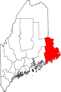
 Grand Lake Stream, Maine Location within the state of Maine | |
| Coordinates: 45°13′47″N 67°43′40″W / 45.22972°N 67.72778°W | |
| Country | United States |
| State | Maine |
| County | Washington |
| Area | |
| • Total | 48.7 sq mi (126.1 km2) |
| • Land | 44.2 sq mi (114.5 km2) |
| • Water | 4.5 sq mi (11.7 km2) |
| Elevation | 292 ft (89 m) |
| Population (2010) | |
| • Total | 109 |
| • Density | 2.2/sq mi (0.86/km2) |
| Time zone | Eastern (EST) (UTC-5) |
| • Summer (DST) | EDT (UTC-4) |
| ZIP code | 04637 |
| Area code(s) | 207 |
| FIPS code | 23-28660 |
| GNIS feature ID | 0582496 |
Grand Lake Stream is a plantation in Washington County, Maine, United States. The population was 109 at the 2010 census.[1]
Grand Lake Stream, the town is named after the stream that flows through the town, which is notable for its excellent landlocked salmon fishery and a fishing tradition that dates to the middle of the 19th century.[2] It also has a long, local tradition of hand-built wooden canoes, ideal for navigating the waters of nearby West Grand Lake.[3]
While the year-round population of Grand Lake Stream is relatively small, there is a large number of visitors in the spring, summer and fall for fishing, hunting, and general relaxation purpose. There are a number of lodges, cabins, and guiding services available.[4] There is also a very active local land trust based in the middle of town, which owns and manages a large portion of the nearby forests and wetlands.[5] Each summer, Grand Lake Stream is also the site of a meeting of prominent American economists.
Geography
According to the United States Census Bureau, the plantation has a total area of 48.7 square miles (126 km2), of which 44.2 square miles (114 km2) is land and 4.5 square miles (12 km2), or 9.26%, is water.
Demographics
As of the census[6] of 2000, there were 150 people, 76 households, and 49 families residing in the plantation. The population density was 3.4 people per square mile (1.3/km²). There were 243 housing units at an average density of 5.5 per square mile (2.1/km²). The racial makeup of the plantation was 96.00% White, 1.33% Native American, 0.67% Asian, and 2.00% from two or more races. Hispanic or Latino of any race were 0.67% of the population. The local Native American community is part of the Passamaquoddy people.
There were 76 households out of which 14.5% had children under the age of 18 living with them, 56.6% were married couples living together, 6.6% had a female householder with no husband present, and 35.5% were non-families. 31.6% of all households were made up of individuals and 17.1% had someone living alone who was 65 years of age or older. The average household size was 1.97 and the average family size was 2.43.
In the plantation the population was spread out with 10.7% under the age of 18, 5.3% from 18 to 24, 16.7% from 25 to 44, 45.3% from 45 to 64, and 22.0% who were 65 years of age or older. The median age was 50 years. For every 100 females there were 97.4 males. For every 100 females age 18 and over, there were 94.2 males.
The median income for a household in the plantation was $28,750, and the median income for a family was $28,750. Males had a median income of $34,375 versus $23,333 for females. The per capita income for the plantation was $17,502. There were 25.0% of families and 24.4% of the population living below the poverty line, including 34.5% of under eighteens and 9.4% of those over 64.
Notable people
- Buffalo Bob Smith, host of Howdy Doody
References
- ↑ "Profile of General Population and Housing Characteristics: 2010 Demographic Profile Data (DP-1): Grand Lake Stream plantation, Washington County, Maine". U.S. Census Bureau, American Factfinder. Retrieved July 20, 2012.
- ↑ "Grand Lake Stream History".
- ↑ "The Grand Lake Canoe: an essay with images".
- ↑ "Grand Lake Stream Chamber of Commerce".
- ↑ "Downeast Lakes Land Trust".
- ↑ "American FactFinder". United States Census Bureau. Retrieved 2008-01-31.
| |||||||||||||||||||||||||||||||||||||
Coordinates: 45°10′46″N 67°46′28″W / 45.17944°N 67.77444°W
