Grand Junction Road
| Grand Junction Road South Australia | |
|---|---|
| General information | |
| Type | Road |
| Length | 21 km (13 mi) |
| Route number(s) |
|
| Major junctions | |
| East end |
|
| |
| West end |
|
| Location(s) | |
| Major suburbs | Holden Hill, Northfield, Gepps Cross, Regency Park, Port Adelaide |
Grand Junction Road is the longest east-west thoroughfare in the Adelaide metropolitan area, and is located approximately 9 kilometres north of the city centre.[1] Travelling from the Port Adelaide region, it is mostly a double lane sealed road (becoming a single lane road past Tolley Road intersection at Hope Valley, South Australia) running 21 kilometres to the base of the Adelaide Hills. The western terminus is at the intersection of Old Port Road, 300 metres east of a causeway, which separates the Port River from West Lakes. The 2.4 kilometre section of road that continues west of Old Port Road to Semaphore South is named Bower Road. The eastern terminus of Grand Junction Road is in the suburb of Hope Valley, at the intersection of Hancock Road and Lower North East Road, just before the latter proceeds into the Adelaide Hills, past Anstey Hill Recreation Park and on towards the towns of Houghton and Inglewood.
History
The Grand Junction is the meeting point of what was once the most accessible route out of Adelaide City to the north (the North Road[2] later called the Lower North Road), and the east-west road from Upper Dry Creek to the Port (later called the Grand Junction Road). It remained so until January 1843 when migrant labourers completed a bridge of 120 feet span across the Torrens River.[3] This enabled travellers to take the more direct route northward on the road from the city to Gawler Town (later called the Great North Road), and the junction of roads at Gepp’s Cross took on a greater significance than the Grand Junction.
The Grand Junction was used to identify a number of nearby features: Grand Junction Inn - February 1850; Grand Junction Store - May 1852; The Grand Junction District - November 1853; The Grand Junction April - 1854; Grand Junction Road - February 1854 (common use), - December 1854 (government use), May 1856 (Road Board use); Grand Junction School 1855; Grand Junction Town December 1856; and Grand Junction Station December 1856.
The Grand Junction Inn was located immediately to the north east of the Grand Junction, the junction of the road east from the port to Upper Dry Creek and the ‘high road’ to the north (Lower North Road). The Inn was built on a triangular shaped forty acres of land, being the southern portion of Section 1001. Its frontage was on Main Junction Road with access to stables from Lower North Road. The Grand Junction Inn was first licensed in June 1850[4] and retained that name while it was licensed. John Merritt became licensee of the Grand Junction Inn in March 1851.[5] The Merritt family purchased the Inn in December 1852[6] after the then owner William Williams was granted an insolvency certificate.[7] John Merritt died in 1858 and the Inn and surrounding land was held by his widow Elizabeth née Figg until she died in 1876. The Merritt family sold the Inn and land in February 1877.[8] In December 1856 land opposite the Grand Junction Inn being the south-western portion of Sections 920 and 921 was subdivided into five acre lots and named the new Grand Junction Township. The lots offered for sale by auction on 30 December at the Grand Junction Inn were said to possess the advantage of valuable frontage on to the Main Junction and Port Roads, and were in the immediate vicinity of the Adelaide and Gawler Town Railway.[9]
In the latter 1850s the road now known as Grand Junction Road, the east-west road from Upper Dry Creek past the Grand Junction Inn to the Port, was variously called ‘road to the Port’,[10] ‘Port Road,’[11] or ‘Grand Junction Hotel and Port Causeway Road’.[12] In November 1854 the Legislative Council requested the Central Road Board to prepare estimates of the probable cost to form a road from the Grand Junction to the Port-road near Albert Town, rendered necessary by the formation of the Adelaide and Port Railway.[13] The road upgrade was shelved. In 1856 the Central Road Board resolved to upgrade the poor state of the road between the Grand Junction Inn and Albert Town, through the Alberton Swamp.[14] The matter was a serious concern for many District Councils north of Adelaide, and in a united front the District Councils flooded the Legislative Council with petitions. On 9 May the Legislative Council passed a motion "for £2,500 to be placed on the Estimates, to form the road from the Grand Junction to Alberton."[15] Official reference to the ‘Grand Junction Road’ was made by government officials in the form of a message received from the Governor-in-Chief: No. 42 when the Governor set apart funds for the Grand Junction-road to the Central Road Board during 1856.[16]
Progress on the Grand Junction Road was slow and it was not until May 1857 that approval was given to metal the new road.[17] The woes of the road dragged on. Tenderers defaulted and further works were ordered, including an additional 1,090 yards of limestone on the swamp that still was not laid by the end of 1858.[18] The road between the Grand Junction Inn and Alberton across the swamp turned into a money pit for the road board and the community. The saga continued for years. In July 1861 the Central Road Board yet again called for tenders to make 19 chains of the Grand Junction Road over sands at Alberton Swamp.[19] Popular usage of the "Grand Junction Road" name greatly increased after the upgrade.
Major intersections
There are a number of major intersections along Grand Junction Road, the largest being the original Grand Junction at Gepps Cross, where Main North Road and Port Wakefield Road meet at a five way crossing. Main North Road joins from the south and continues on to the north-east, towards Parafield, Elizabeth and Gawler, while Port Wakefield Road begins at this location, travelling due north to the northern Adelaide Plains and 90 kilometres to the town of Port Wakefield.
- Begin
 at junction with Lower North East Road
  : Vista
-
 North East Road
  : Holden Hill
 - Hampstead Road
 / Briens Road: Northfield - Route Changed to
- Port Wakefield Road
 / Main North Road
  : Gepps Cross
 - Cavan Road
 : Kilburn
 - South Road

 : Regency Park - Route Changed to
 - Hanson Road: Mansfield Park - Northbound to

- Port Road
 : Alberton
 - Terminates at intersection with Old Port Road: Queenstown
-
- Continues as Bower Road.
The road is also officially part of the National Highway system, and therefore attracts a shield and federal funding. The National Highway runs south (from Port Augusta) off the Salisbury Highway/South Road connector intersection, heads east along Grand Junction Road through Gepps Cross (where it meets another National Highway, Main North Road (A20), north-east to Sydney), to the Hampstead Road intersection a few kilometres away where it turns south (to Melbourne). Grand Junction Road continues on without the National shield.
Railway crossings
Due to the configuration of the Adelaide railway system north of the CBD, there are a number of current and former railway crossings over Grand Junction Road. These include:
- The bridge over the Adelaide to Outer Harbor railway line at Alberton
- A level crossing over the Dry Creek-Port Adelaide railway line, at Rosewater
- A dismantled level crossing in the proximity of Glenroy Street and Eastern Parade, at Pennington and Ottoway (On the former Finsbury railway line)
- The bridge over the Adelaide to Gawler and Adelaide-Port Augusta railway at Kilburn and Wingfield
- The Adelaide O-Bahn underpass at Holden Hill (Dedicated Busway)
Educational institutions
Adjoining institutions
A number of schools and other education institutions front on to Grand Junction Road. These include:
- Enfield High School at Enfield
- Gepps Cross Girls School, Gepps Cross
- St. Pauls College, Gilles Plains
- Tauondi College at Port Adelaide, opposite Alberton
- Torrens Valley Christian School at Hope Valley
Non-adjoining institutions
There are also schools which are located within a few streets of Grand Junction Road, in adjacent suburbs:
- Cedar College on Fosters Road, Northgate
- Gepps Cross Special School and Gepps Cross Primary School, both in the suburb of Blair Athol
- Heritage College, Oakden
- Kilburn Primary School, Kilburn
- Mansfield Park Primary School, Mansfield Park
- Modbury High School, Modbury
- Modbury Primary School, Hope Valley
- Northfield Primary School, Northfield
- Pennington Primary School, Pennington
- Mount Carmel College, Rosewater
- Torrens Valley TAFE and Wandana Primary School, both in Gilles Plains
It also passes Yatala Labour Prison, the Adelaide Pre-Release Centre and the Adelaide Women's Prison at Northfield.
Gallery
-
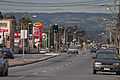
Looking down Grand Junction Road towards the Adelaide Hills from Rosewater.
-
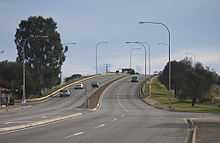
The bridge over the Adelaide to Port Adelaide railway line at Alberton.
-

Location of Grand Junction Road in the Adelaide Metropolitan area.
See also
Australian Roads portal
References
- ↑ 2003 Adelaide Street Directory, 41st Edition. UBD (A Division of Universal Press Pty Ltd). 2003. ISBN 0-7319-1441-4.
- ↑ South Australian Register (Adelaide, SA: 1839-1900) Friday 20 March 1857, page 4
- ↑ Southern Australian (Adelaide, SA : 1838 - 1844) Friday 6 January 1843, page 2
- ↑ South Australian Register (Adelaide, SA: 1839-1900) Tuesday 11 June 1850, page 3
- ↑ South Australian Register (Adelaide, SA: 1839 - 1900) Tuesday 10 June 1851, page 3
- ↑ [advertised sale]South Australian Register (Adelaide, SA: 1839-1900) Friday 13 August 1852, page 4
- ↑ South Australian Register (Adelaide, SA :1839 - 1900) Monday 2 August 1852, page 3
- ↑ [advertised sale]South Australian Register (Adelaide, SA: 1839-1900) Wednesday 7 March 1877
- ↑ South Australian Register (Adelaide, SA: 1839-1900) Monday 22 December 1856, page 4
- ↑ South Australian Register (Adelaide, SA: 1839-1900) Friday 2 February 1855, page 4
- ↑ South Australian Register (Adelaide, SA: 1839-1900) Monday 22 December 1856, page 4
- ↑ South Australian Weekly Chronicle (Adelaide, SA : 1858 - 1867) Saturday 27 May 1865, page 4
- ↑ South Australian Register (Adelaide, SA : 1839 - 1900) Friday 10 November 1854, page 3
- ↑ South Australian Register (Adelaide, SA : 1839 - 1900) Friday 11 April 1856, page 3
- ↑ South Australian Register (Adelaide, SA : 1839 - 1900) Monday 23 June 1856, page 2
- ↑ South Australian Register (Adelaide, SA : 1839 - 1900) Thursday 15 May 1856, page 3
- ↑ South Australian Register (Adelaide, SA : 1839 - 1900) Friday 22 May 1857, page 3
- ↑ South Australian Register (Adelaide, SA : 1839 - 1900) Saturday 23 January 1858, page 3
South Australian Register (Adelaide, SA : 1839 - 1900) Friday 5 November 1858, page 3
The South Australian Advertiser (Adelaide, SA : 1858 - 1889) Monday 10 January 1859, page 3 - ↑ South Australian Register (Adelaide, SA : 1839 - 1900) Thursday 4 July 1861, page 3
| |||||||||||||||||||||||||