Grand Golliat
| Grand Golliat | |
|---|---|
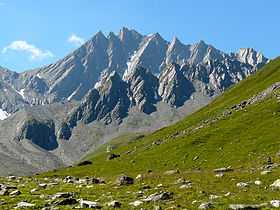 The north side | |
| Elevation | 3,238 m (10,623 ft) |
| Prominence | 368 m (1,207 ft)[1] |
| Parent peak | Grande Rochère |
| Location | |
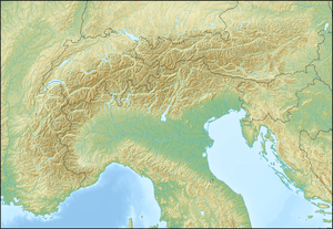 Grand Golliat Location in the Alps | |
| Location |
Aosta Valley, Italy Valais, Switzerland |
| Range | Pennine Alps |
| Coordinates | 45°51′33.3″N 7°06′04.3″E / 45.859250°N 7.101194°ECoordinates: 45°51′33.3″N 7°06′04.3″E / 45.859250°N 7.101194°E |
The Grand Golliat (also spelled Grand Golliaz) is a mountain of the Pennine Alps, located between the Petit Col Ferret and the Great St. Bernard Pass. At 3,238 metres above sea level, its summit straddles the border between Switzerland and Italy, separating the Swiss canton of Valais from the Italian region of Aosta Valley. The name Golliat comes "gouilles" or small lakes located on the Italian side of the mountain.[2]
The Grand Golliat is the southernmost mountain rising above 3,000 metres in Switzerland.
References
- ↑ Retrieved from the Swisstopo topographic maps. The key col is located south of the Aiguille de la Belle Combe at 2,870 metres.
- ↑ The Grand Golliat orsieres.ch. Retrieved on 2011-10-18