Grand Erg Occidental
| Grand Erg Occidental العرق الغربي الكبير | |
|---|---|
| Erg | |
|
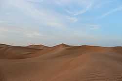
The desolate landscape of the Grand Erg Occidental near Timimoun | |
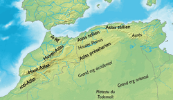
 Map of the Maghreb showing the Grand Erg Occidental. | |
| Country | Algeria |
| Elevation | 500 m (1,600 ft) |
The Grand Erg Occidental (Arabic: العرق الغربي الكبير, al-ʿIrq al-Gharbī al-Kabīr), (also known as the Western Sand Sea) is the second largest erg in northern Algeria after the Grand Erg Oriental.
Geography
It is a desert natural region that receives less than 50 mm (1,96 in) of rainfall per year.[1] The mean elevation of the Grand Erg Occidental is about 500 m, on average higher than the elevation of the Grand Erg Oriental, but not as high as the neighboring Tademaït to the southwest. This desolate region is a practically uninhabited area; there are no permanent villages and there are no roads crossing it.[2]
Features
-

Grand Erg Occidental (centre), as seen from space
-

Ksar of Aghlad; a Ksar -which means castle- was a structure where a tribe used to live
See also
References
- ↑ "STS059-238-088 Grand Erg Occidental, North Central Algeria April 1994". Earth from Space. NASA. Retrieved 2007-01-18.
- ↑ "GRAND ERG OCCIDENTAL: The endless dunes". Adventures in Algeria. LexicOrient. Retrieved 2007-01-18.
| Wikimedia Commons has media related to Grand Erg Occidental. |
Coordinates: 30°40′N 0°00′E / 30.667°N 0.000°E
