Grafton, West Virginia
| Grafton, West Virginia | |
|---|---|
| City | |
 Location of Grafton, West Virginia | |
| Coordinates: 39°20′30″N 80°1′11″W / 39.34167°N 80.01972°WCoordinates: 39°20′30″N 80°1′11″W / 39.34167°N 80.01972°W | |
| Country | United States |
| State | West Virginia |
| County | Taylor |
| Government | |
| • Mayor | G. Thomas Bartlett III |
| Area[1] | |
| • Total | 3.80 sq mi (9.84 km2) |
| • Land | 3.67 sq mi (9.51 km2) |
| • Water | 0.13 sq mi (0.34 km2) |
| Elevation | 1,024 ft (312 m) |
| Population (2010)[2] | |
| • Total | 5,164 |
| • Estimate (2012[3]) | 5,177 |
| • Density | 1,407.1/sq mi (543.3/km2) |
| Time zone | Eastern (EST) (UTC-5) |
| • Summer (DST) | EDT (UTC-4) |
| ZIP code | 26354 |
| Area code(s) | 304 |
| FIPS code | 54-32716[4] |
| GNIS feature ID | 1554590[5] |
Grafton is a city in, and county seat[6] of, Taylor County, West Virginia, USA. The population was 5,164 at the 2010 census. The only two national cemeteries in West Virginia are located in Grafton. Mother's Day was founded in Grafton on May 10, 1908; the city is the home to the International Mother's Day Shrine.[7] Grafton was one of the first places to observe Memorial Day in the United States.[7] Grafton is a junction point for the Baltimore and Ohio Railroad; the southwestern line wends its way to Clarksburg while the northwestern line runs through Fairmont then to Morgantown; to the East lies Piedmont, where it joins the old Piedmont and Cumberland Railway.
History


When James Current traded a horse for 1300 acres of land in Virginia it was situated where the City of Grafton, West Virginia is today. In 1751, he hired George Washington to first act was to stake his property.[8] James Current and his wife Margaret are buried in Bluemont Cemetery; his is the only Revolutionary War soldier grave in Grafton.[8] Grafton is near what may be called the headwaters of the Monongahela River, which now form in the lee of the Tygart Valley Dam. The Tygart Valley was first settled by Europeans in 1753 when David Tygart (for whom the valley and river are named) with his family.
The Baltimore and Ohio Railroad arrived in 1852 during the construction of the nation's first trans-Appalachian railroad.[8] The City of Grafton was chartered in 1856. It may have been named for John Grafton, a civil engineer of the B&O.[8] Alternatively, it may be that railroad crews referred to the town as "Graftin" because it was the point at which a number of branch railroad lines met (grafted to) the railroad's mainline.[9]
Thornsberry Bailey Brown, was the first soldier killed in the Civil War, at Fetterman, now part of Grafton.[8] He is interred at the Grafton National Cemetery, which opened in 1868 in order to provide a burial ground for Union soldiers who died in West Virginia’s military hospitals and battlefields. The Federal Government selected Grafton as the site of the national cemetery for its proximity to the Maple Avenue Cemetery, which already contained the remains of many US Civil War veterans. On June 14, the first governor of West Virginia, Arthur Boreman, officially dedicated the cemetery. The cemetery contains more than 2,100 interments, including 1,252 Union soldiers. 613 Civil War soldiers are buried as unknowns and their graves are identified with six-inch square marble markers. In 1875, an Act of Congress was passed authorizing “preservation and maintenance” of the cemetery, and two plaques on the lowest terrace contain stanzas from Theodore O’Hara’s poem “Bivouac of the Dead.” Memorial Day services at Grafton National Cemetery include a special tradition known locally as “Flower Strewing Day.” Historically, each year a parade begins in downtown Grafton and winds its way towards the cemetery, where children from the town place flowers at each grave marker. The day concludes with a memorial service officiated by a prominent West Virginian. Every governor, except one who served a term of only six days, has spoken at the Grafton National Cemetery at least once during their term in office.[10]
The Second New Deal served in 1936 to construct the "Tigrett Valley Dam" (sic), as remarked by Franklin Delano Roosevelt when he visited the city 1 October on a stump tour prior to his landslide re-election that 3 November. Upstream of the dam, Tygart Lake State Park was formed by this structure. The Tygart Valley Rover flows through Grafton.
The 1985 Election day floods were notable in Grafton. Most of the 47 people killed in this incident were in Pendleton and Grant counties, according to the National Weather Service.[11] Flooding in the Tygart Valley River basin (tributary to the Monongahela River) set new records for peak discharge at all five of the long-term unregulated gaging stations in the basin. However, the peaks were not as extreme, relative to the previous peaks of record, as those in the Cheat River and South Branch Potomac River basins. Recurrence intervals for the peaks equaled or exceeded 50 years at all five of the aforementioned sites in the Tygart basin, and four were in excess of 100 years. Also, at one newly established gaging station, Three Forks Creek near Grafton, the peak discharge, 12,000 ft3/s, was estimated to exceed the 100-year recurrence interval.[12]
The Grafton Downtown Commercial Historic District was listed on the National Register of Historic Places in 1984 and the Grafton National Cemetery was listed in 1982.[13]
Geography
Grafton is located at 39°20′30″N 80°1′11″W / 39.34167°N 80.01972°W (39.341757, -80.019817),[14] along the Tygart Valley River. Tygart Lake State Park is a major nearby tourist attraction.
According to the United States Census Bureau, the city has a total area of 3.80 square miles (9.84 km2), of which, 3.67 square miles (9.51 km2) is land and 0.13 square miles (0.34 km2) is water.[1]
Demographics
2010 census
As of the census[2] of 2010, there were 5,164 people, 2,192 households, and 1,357 families residing in the city. The population density was 1,407.1 inhabitants per square mile (543.3/km2). There were 2,512 housing units at an average density of 684.5 per square mile (264.3/km2). The racial makeup of the city was 97.1% White, 0.7% African American, 0.3% Native American, 0.2% Asian, 0.1% from other races, and 1.5% from two or more races. Hispanic or Latino of any race were 0.9% of the population.
There were 2,192 households of which 29.0% had children under the age of 18 living with them, 41.3% were married couples living together, 15.0% had a female householder with no husband present, 5.6% had a male householder with no wife present, and 38.1% were non-families. 33.8% of all households were made up of individuals and 15.3% had someone living alone who was 65 years of age or older. The average household size was 2.29 and the average family size was 2.92.
The median age in the city was 41.7 years. 21.9% of residents were under the age of 18; 8.4% were between the ages of 18 and 24; 23.9% were from 25 to 44; 26.9% were from 45 to 64; and 19% were 65 years of age or older. The gender makeup of the city was 47.6% male and 52.4% female.
2000 census
As of the census[4] of 2000, there were 5,489 people, 2,277 households, and 1,448 families residing in the city. The population density was 1,491.1 people per square mile (575.9/km²). There were 2,575 housing units at an average density of 699.5 per square mile (270.2/km²). The racial makeup of the city was 98.07% White, 0.84% African American, 0.27% Native American, 0.16% Asian, 0.05% from other races, and 0.60% from two or more races. Hispanic or Latino people of any race comprised 0.67% of the population.
There were 2,277 households out of which 29.4% had children under the age of 18 living with them, 45.4% were married couples living together, 14.2% had a female householder with no husband present, and 36.4% were non-families. 33.2% of all households were made up of individuals and 17.9% had someone living alone who was 65 years of age or older. The average household size was 2.33 and the average family size was 2.95.
In the city the population was spread out with 23.6% under the age of 18, 7.7% from 18 to 24, 25.4% from 25 to 44, 22.0% from 45 to 64, and 21.3% who were 65 years of age or older. The median age was 40 years. For every 100 females there were 87.1 males. For every 100 females age 18 and over, there were 82.2 males.
The median income for a household in the city was $18,981, and the median income for a family was $25,161. Males had a median income of $22,765 versus $16,629 for females. The per capita income for the city was $9,616. About 26.6% of families and 35.1% of the population were below the poverty line, including 51.2% of those under age 18 and 15.7% of those age 65 or over.
Notable people
- Clair Bee, basketball coach for Long Island University & author
- Marmaduke H. Dent, justice of the West Virginia Supreme Court of Appeals (born in Granville, but lived in Grafton most of his life)
- Frank Gatski, Pro Football Hall of Fame center for the Cleveland Browns
- Anna Jarvis, founder of Mother's Day
- Frances Benjamin Johnston, early photographer and photojournalist; born in Grafton
- George Preston Marshall, longtime owner and president of the Washington Redskins
- Eldora Marie Bolyard Nuzum, first female editor of a daily newspaper in WV and interviewer of U.S. presidents[15]
Gallery
-
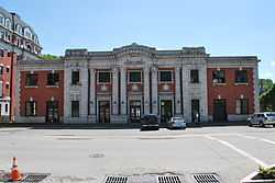
Grafton Baltimore and Ohio Railroad Depot
-

Grafton National Cemerery
-

International Mothers Day Shrine
-
%2C_1818_-_9-1905.png)
Valley Falls, near Grafton
References
Citations
- ↑ 1.0 1.1 "US Gazetteer files 2010". United States Census Bureau. Retrieved 2013-01-24.
- ↑ 2.0 2.1 "American FactFinder". United States Census Bureau. Retrieved 2013-01-24.
- ↑ "Population Estimates". United States Census Bureau. Retrieved 2013-06-26.
- ↑ 4.0 4.1 "American FactFinder". United States Census Bureau. Retrieved 2008-01-31.
- ↑ "US Board on Geographic Names". United States Geological Survey. 2007-10-25. Retrieved 2008-01-31.
- ↑ "Find a County". National Association of Counties. Retrieved 2011-06-07.
- ↑ 7.0 7.1 nps.gov: "National Register of Historic Places - Andrews Methodist Episcopal Church"
- ↑ 8.0 8.1 8.2 8.3 8.4 graftonwv.com: "ABOUT GRAFTON"
- ↑ Gannett, Henry (1905). The Origin of Certain Place Names in the United States. Govt. Print. Off. p. 140.
- ↑ nps.gov: "Civil War Era National Cemeteries: Honoring Those Who Served - Grafton National Cemetery"
- ↑ West Virginia Gazette: "Remembering the '85 floods" (D. White) 4 Nov 2010
- ↑ "FLOODS IN WEST VIRGINIA, VIRGINIA, PENNSYLVANIA, AND MARYLAND, NOVEMBER 1985" (DH Carpenter) USGS WRI report 88-4213 Towson, MD, 1990
- ↑ "National Register Information System". National Register of Historic Places. National Park Service. 2009-03-13.
- ↑ "US Gazetteer files: 2010, 2000, and 1990". United States Census Bureau. 2011-02-12. Retrieved 2011-04-23.
- ↑ Higgins,Cara, "WVPA Inducts Nuzum Into Hall of Fame", The Inter-Mountain, August 6, 2009.
Other sources
- Eldora Marie Bolyard Nuzum, The West Virginia Encyclopedia, The WV Humanities Council, Charleston, WV, 2006.
- Wooley, J.T, and Peters, Gerhard, "The American Presidency", December 1, 1978 Invitational White House Interview of President Jimmy Carter by Eldora Nuzum about the Appalachian Regional Commission, University of California, Santa Barbara, CA, 1999–2009.
External links
| Wikimedia Commons has media related to Grafton, West Virginia. |
- City of Grafton, West Virginia
- International Mother's Day Shrine
- Taylor County, West Virginia
- Anna Jarvis Birthplace Museum
- Tygart Lake State Park
- The Grafton 123 Coffee House & Cafe
- Mountain Statesman newspaper
- Grafton High School
- Taylor County Historical & Genealogical Society
- Valley Falls Reception Center
- West Virginia (WV) Cyclopedia article
- Taylor County Arts Council
| |||||||||||||||||||||
