| Name |
Location |
Type |
Completed | Date designated |
Grid ref.
Geo-coordinates |
Entry number | Image |
|
|
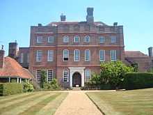
| Matfield House |
Matfield, Brenchley, Tunbridge Wells |
House |
Dated 1738 |
01954-10-20-000020 October 1954 |
TQ6581541928
51°09′09″N 0°22′10″E / 51.152589°N 0.36954°E / 51.152589; 0.36954 (Matfield House) |
1250644 |
More images
|
| Stable Block immediately North East of Matfield House |
Matfield, Brenchley |
Stable |
1736 on clock |
01954-10-20-000020 October 1954 |
TQ6583541943
51°09′10″N 0°22′11″E / 51.152718°N 0.369832°E / 51.152718; 0.369832 (Stable Block immediately North East of Matfield House) |
1250646 |
More images
|
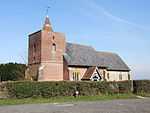
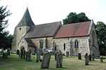
| Parish Church of All Saints |
Brenchley |
Parish Church |
Evidence of pre 13th century masonry |
01954-10-20-000020 October 1954 |
TQ6796941708
51°09′00″N 0°24′01″E / 51.149985°N 0.400207°E / 51.149985; 0.400207 (Parish Church of All Saints) |
1249609 |
More images
|
| Church of All Saints |
Capel |
Church |
'Lately rebuilt' in 1798 |
01954-10-20-000020 October 1954 |
TQ6215645407
51°11′06″N 0°19′08″E / 51.184894°N 0.318835°E / 51.184894; 0.318835 (Church of All Saints) |
1261437 |
More images
|
| Church of St Thomas à Becket |
Capel |
Parish Church |
Norman origins |
01954-10-20-000020 October 1954 |
TQ6373444513
51°10′35″N 0°20′28″E / 51.176413°N 0.340987°E / 51.176413; 0.340987 (Church of St Thomas à Becket) |
1262867 |
More images
|
| Somerhill |
Somerhill Park, Capel |
School |
1954 |
01954-10-20-000020 October 1954 |
TQ6086745121
51°10′58″N 0°18′01″E / 51.182689°N 0.300279°E / 51.182689; 0.300279 (Somerhill) |
1253489 |
|
| Barn 60 Yards North of the West Range of Sissinghurst Castle |
Sissinghurst, Cranbrook |
Barn |
Early 16th century |
01967-06-20-000020 June 1967 |
TQ8078138392
51°06′59″N 0°34′54″E / 51.116298°N 0.581536°E / 51.116298; 0.581536 (Barn 60 Yards North of the West Range of Sissinghurst Castle) |
1099119 |
|
| Church of St Dunstan |
Cranbrook |
Obelisk |
1736 |
01967-06-20-000020 June 1967 |
TQ7768936169
51°05′50″N 0°32′11″E / 51.097294°N 0.536312°E / 51.097294; 0.536312 (Church of St Dunstan) |
1099931 |
More images
|
| Cranbrook or Union Windmill |
Cranbrook |
Smock Mill |
1814 |
01952-06-09-00009 June 1952 |
TQ7790635948
51°05′43″N 0°32′21″E / 51.095242°N 0.539299°E / 51.095242; 0.539299 (Cranbrook or Union Windmill) |
1356175 |
More images
|
| Old Wilsley |
Wilsley Green, Cranbrook |
Kitchen |
Former |
01952-06-09-00009 June 1952 |
TQ7796336997
51°06′17″N 0°32′26″E / 51.104647°N 0.540629°E / 51.104647; 0.540629 (Old Wilsley) |
1338663 |

|
| Tower and Walls 30 Yards East of the West Range at Sissinghurst Castle |
Sissinghurst, Cranbrook |
Tower |
c. 1570 |
01952-06-09-00009 June 1952 |
TQ8080538315
51°06′56″N 0°34′55″E / 51.115598°N 0.58184°E / 51.115598; 0.58184 (Tower and Walls 30 Yards East of the West Range at Sissinghurst Castle) |
1084163 |
|
| West Range at Sissinghurst Castle |
Sissinghurst, Cranbrook |
Apartment |
1986 |
01952-06-09-00009 June 1952 |
TQ8077638324
51°06′56″N 0°34′53″E / 51.115688°N 0.581431°E / 51.115688; 0.581431 (West Range at Sissinghurst Castle) |
1346285 |
|
| Christ Church |
Kilndown, Goudhurst |
Parish Church |
1839-41 |
01980-09-26-000026 September 1980 |
TQ7006035187
51°05′27″N 0°25′37″E / 51.090784°N 0.427002°E / 51.090784; 0.427002 (Christ Church) |
1338690 |
More images
|
| Church of St Mary |
Goudhurst |
Parish Church |
13th century to 15th century |
01967-06-20-000020 June 1967 |
TQ7239437810
51°06′49″N 0°27′42″E / 51.113652°N 0.46155°E / 51.113652; 0.46155 (Church of St Mary) |
1338671 |
More images
|
| Finchcocks |
Finchcocks, Goudhurst |
House |
dated 1725 |
01952-06-09-00009 June 1952 |
TQ7003836460
51°06′08″N 0°25′38″E / 51.102227°N 0.427288°E / 51.102227; 0.427288 (Finchcocks) |
1318935 |
More images
|
| Church of St Laurence |
Hawkhurst |
Cross |
1917 |
01967-06-20-000020 June 1967 |
TQ7559629449
51°02′15″N 0°30′11″E / 51.037569°N 0.503191°E / 51.037569; 0.503191 (Church of St Laurence) |
1120819 |
More images
|
| Church of St Margaret |
Horsmonden |
Parish Church |
14th century |
01954-10-20-000020 October 1954 |
TQ7038338112
51°07′01″N 0°25′59″E / 51.116966°N 0.43299°E / 51.116966; 0.43299 (Church of St Margaret) |
1087022 |
More images
|
| Church of St Mary |
Lamberhurst |
Parish Church |
12th century |
01954-10-20-000020 October 1954 |
TQ6820736580
51°06′14″N 0°24′04″E / 51.103845°N 0.401216°E / 51.103845; 0.401216 (Church of St Mary) |
1084519 |
More images
|
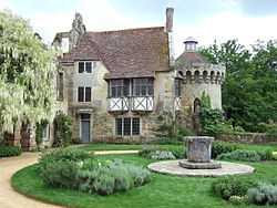
| Scotney Castle with Courtyards and Garden Terrace |
Lamberhurst |
House |
1837-44 |
01954-10-20-000020 October 1954 |
TQ6873435373
51°05′34″N 0°24′29″E / 51.092846°N 0.408173°E / 51.092846; 0.408173 (Scotney Castle with Courtyards and Garden Terrace) |
1336699 |
|
| The Ruins of Old Scotney Castle |
Scotney, Lamberhurst |
Castle |
1378 |
01954-10-20-000020 October 1954 |
TQ6896835229
51°05′29″N 0°24′41″E / 51.091483°N 0.411444°E / 51.091483; 0.411444 (The Ruins of Old Scotney Castle) |
1085287 |
|
| Old Church of St Peter |
Pembury |
Parish Church |
Norman |
01954-10-20-000020 October 1954 |
TQ6260442979
51°09′47″N 0°19′27″E / 51.162953°N 0.324142°E / 51.162953; 0.324142 (Old Church of St Peter) |
1254444 |
More images
|
| Buildings of the Service Courtyard Adjoining South of Groombridge Place Including the Walls of the Herb Garden |
Old Groombridge, Speldhurst |
House |
c. 1660 |
01954-10-20-000020 October 1954 |
TQ5335637592
51°07′02″N 0°11′23″E / 51.1171°N 0.189695°E / 51.1171; 0.189695 (Buildings of the Service Courtyard Adjoining South of Groombridge Place Including the Walls of the Herb Garden) |
1260883 |
|
| Chapel of St John the Evangelist |
Old Groombridge, Speldhurst |
Chapel of Ease |
1625 |
01954-10-20-000020 October 1954 |
TQ5306537682
51°07′05″N 0°11′08″E / 51.117986°N 0.185578°E / 51.117986; 0.185578 (Chapel of St John the Evangelist) |
1240708 |
More images
|
| Church of St Martin of Tours |
Ashurst, Speldhurst |
Church |
14th century |
01954-10-20-000020 October 1954 |
TQ5117339037
51°07′50″N 0°09′33″E / 51.130664°N 0.159134°E / 51.130664; 0.159134 (Church of St Martin of Tours) |
1074896 |
More images
|
| Garden Walls and Features of the Terraced Garden (including Ivy Cottage) approx. 30 Metres North of Groombridge Place |
Old Groombridge, Speldhurst |
House |
c. 1980 |
01954-10-20-000020 October 1954 |
TQ5328437681
51°07′05″N 0°11′19″E / 51.117919°N 0.188704°E / 51.117919; 0.188704 (Garden Walls and Features of the Terraced Garden (including Ivy Cottage) approx. 30 Metres North of Groombridge Place) |
1240706 |
|
| Groombridge Place |
Old Groombridge, Speldhurst |
Country House |
Between 1652 and 1674 |
01954-10-20-000020 October 1954 |
TQ5334137619
51°07′02″N 0°11′22″E / 51.117347°N 0.189492°E / 51.117347; 0.189492 (Groombridge Place) |
1260959 |
|
| Groombridge Place Moat, Walls and Bridge including the West Gateway and Cottage on the North Bridge |
Old Groombridge, Speldhurst |
House |
Second half of 17th century |
01954-10-20-000020 October 1954 |
TQ5322937625
51°07′03″N 0°11′16″E / 51.11743°N 0.187895°E / 51.11743; 0.187895 (Groombridge Place Moat, Walls and Bridge including the West Gateway and Cottage on the North Bridge) |
1260960 |
More images
|
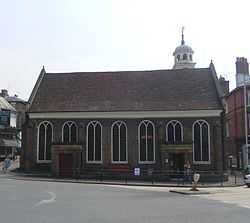
| The Church of King Charles the Martyr |
Tunbridge Wells |
Church |
1676-1684 |
01952-05-20-000020 May 1952 |
TQ5819738810
51°07′36″N 0°15′34″E / 51.126729°N 0.259338°E / 51.126729; 0.259338 (The Church of King Charles the Martyr) |
1084478 |
More images |


.JPG)


.JPG)