Grade I listed buildings in Swansea

Swansea shown within Wales
In the United Kingdom, the term listed building refers to a building or other structure officially designated as being of special architectural, historical, or cultural significance; Grade I structures are those considered to be "buildings of exceptional interest".[1] Listing was begun by a provision in the Town and Country Planning Act 1947. Once listed, strict limitations are imposed on the modifications allowed to a building's structure or fittings. In Wales, the authority for listing under the Planning (Listed Buildings and Conservation Areas) Act 1990[2] rests with Cadw.
Buildings
| Name | Location | Date Listed | Grid Ref.[note 1] Geo-coordinates |
Function | Notes | HB No[note 2] | Image |
|---|---|---|---|---|---|---|---|
| Oystermouth Castle | Mumbles | 23 April 1952 | SS6132288354 51°34′37″N 4°00′10″W / 51.576955383°N 4.0026805136922°W |
Approximately 500m NW of Oystermouth church, prominently sited on high ground overlooking the village and Swansea Bay. | 11518 | 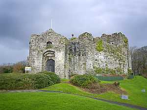
| |
| Church of St Cadoc, Cheriton | Cheriton | 6 March 1964 | SS4504893186 51°36′58″N 4°14′22″W / 51.616119697317°N 4.2394853056766°W |
In the hamlet of Cheriton, east of Llanmadoc. Stone churchyard wall on three sides, with iron railing, gate, and lamp arch to east. Concrete path to church door. The grave stone (renewed) of Rev WD Davies is close to porch door. | 11521 | 
| |
| Oxwich Castle | Penrice | 6 September 1952 | SS4978086283 51°33′19″N 4°10′06″W / 51.555383161423°N 4.1682353391636°W |
On high ground 0.5km south of Oxwich village | 11530 | 
| |
| Penrice Castle (Mansion) | Penrice | 6 September 1952 | SS4967188384 51°34′27″N 4°10′15″W / 51.574231296572°N 4.170705592426°W |
100m south of Penrice Castle Ancient Monument, reached by a private drive from the A4118. | 11531 | 
| |
| Weobley Castle | Llanrhidian Lower | 6 March 1964 | SS4782092730 51°36′46″N 4°11′57″W / 51.612780834967°N 4.1992812330533°W |
250m north of the minor road from Oldwalls to Landimore, on a scarp overlooking Llandimore Marsh and the Burry Estuary. | 11534 | 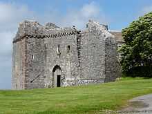
| |
| Swansea Castle | City centre | 23 April 1952 | SS6571693067 51°37′13″N 3°56′28″W / 51.620373298804°N 3.9411155025269°W |
In the centre of the city, on the curving W bank of the former course of the River Tawe. | 11568 | 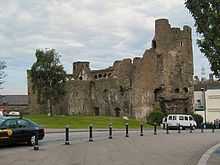
| |
| Tabernacle Chapel | Morriston | 30 September 1993 | SS6695397818 51°39′48″N 3°55′30″W / 51.663360929042°N 3.9250660145806°W |
11744 | 
| ||
| Guildhall | Uplands | 25 July 1994 | SS6436092391 51°36′50″N 3°57′38″W / 51.613972882688°N 3.9604285748025°W |
Between Guildhall Road North and Guildhall Road South, to NE of Victoria Park. | 14594 |  |
Notes
- ↑ Sometimes known as OSGB36, the grid reference is based on the British national grid reference system used by the Ordnance Survey.
- ↑ The "HB Number" is a unique number assigned to each listed building by Cadw.
References
- ↑ "Buildings & Conservation Areas". Cadw. Retrieved 18 June 2013.
- ↑ "Planning (Listed Buildings and Conservation Areas) Act 1990". The National Archives. Retrieved 18 June 2013.
See also
External links
![]() Media related to Grade I listed buildings in Swansea at Wikimedia Commons
Media related to Grade I listed buildings in Swansea at Wikimedia Commons
