| Name |
Location |
Type |
Completed | Date designated |
Grid ref.
Geo-coordinates |
Entry number | Image |
|
|
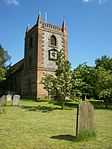
| Parish Church of Saint Peter and Saint Paul |
New Ash Green, Ash-cum-Ridley |
Parish Church |
13th century |
01967-06-01-00001 June 1967 |
TQ6018264562
51°21′27″N 0°17′57″E / 51.35755°N 0.299191°E / 51.35755; 0.299191 (Parish Church of Saint Peter and Saint Paul) |
1235106 |
|
| Brasted Place and Saxon Cross |
Brasted |
Villa |
c. 1784 |
01954-09-10-000010 September 1954 |
TQ4766854996
51°16′30″N 0°06′56″E / 51.274982°N 0.11564°E / 51.274982; 0.11564 (Brasted Place and Saxon Cross) |
1336432 |

|
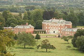
| Chevening House |
Chevening |
House |
Second quarter of 17th century |
01954-09-10-000010 September 1954 |
TQ4870857667
51°17′55″N 0°07′54″E / 51.298712°N 0.13165°E / 51.298712; 0.13165 (Chevening House) |
1085853 |
More images
|
| Church of St Botolph |
Chevening |
Church |
12th century |
01954-09-10-000010 September 1954 |
TQ4892057695
51°17′56″N 0°08′05″E / 51.298908°N 0.1347°E / 51.298908; 0.1347 (Church of St Botolph) |
1336446 |
More images
|
| Church of St Mary Magdalene |
Cowden |
Church |
15th century |
01954-09-10-000010 September 1954 |
TQ4662140472
51°08′41″N 0°05′41″E / 51.144741°N 0.09471°E / 51.144741; 0.09471 (Church of St Mary Magdalene) |
1085906 |
More images
|
| Church of St Peter and St Paul |
Edenbridge |
Church |
Late C11-early 12th century |
01954-09-10-000010 September 1954 |
TQ4449046130
51°11′46″N 0°04′00″E / 51.196126°N 0.066538°E / 51.196126; 0.066538 (Church of St Peter and St Paul) |
1085930 |
|
| Church of Saint Botolph |
Lullingstone, Eynsford |
Church |
Norman |
01967-06-01-00001 June 1967 |
TQ5299264436
51°21′30″N 0°11′45″E / 51.358398°N 0.195955°E / 51.358398; 0.195955 (Church of Saint Botolph) |
1222051 |
More images
|
| Church of Saint Martin |
Eynsford |
Church |
12th century |
01967-06-01-00001 June 1967 |
TQ5404865467
51°22′03″N 0°12′42″E / 51.367377°N 0.211556°E / 51.367377; 0.211556 (Church of Saint Martin) |
1217157 |
More images
|
| The Gatehouse to Lullingstone Castle |
Lullingstone, Eynsford |
Gatehouse |
Second half 16th century |
01967-06-01-00001 June 1967 |
TQ5292864411
51°21′29″N 0°11′42″E / 51.358191°N 0.195026°E / 51.358191; 0.195026 (The Gatehouse to Lullingstone Castle) |
1217173 |
More images
|
| Church of Saint Peter and Saint Paul |
Farningham |
Church |
13th century |
01967-06-01-00001 June 1967 |
TQ5471466904
51°22′48″N 0°13′18″E / 51.380107°N 0.221741°E / 51.380107; 0.221741 (Church of Saint Peter and Saint Paul) |
1237990 |
More images
|
| Church of Saint Mary |
Fawkham |
Church |
Norman |
01967-06-01-00001 June 1967 |
TQ5970068047
51°23′20″N 0°17′38″E / 51.388997°N 0.293839°E / 51.388997; 0.293839 (Church of Saint Mary) |
1238236 |
More images
|
| Church of All Saints |
Hartley |
Church |
12th century |
01967-06-01-00001 June 1967 |
TQ6131966665
51°22′34″N 0°18′59″E / 51.376123°N 0.31646°E / 51.376123; 0.31646 (Church of All Saints) |
1238242 |
More images
|
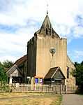
| Church of St Peter |
Hever |
Church |
1856 |
01975-01-16-000016 January 1975 |
TQ4765544849
51°11′02″N 0°06′41″E / 51.183807°N 0.111276°E / 51.183807; 0.111276 (Church of St Peter) |
1258341 |
More images
|
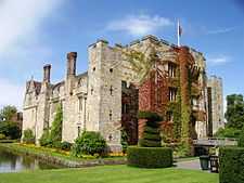
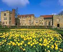
| Hever Castle |
Hever |
Castle |
Late C13-Early 14th century |
01954-09-10-000010 September 1954 |
TQ4783045188
51°11′13″N 0°06′50″E / 51.186808°N 0.113918°E / 51.186808; 0.113918 (Hever Castle) |
1273465 |
More images
|
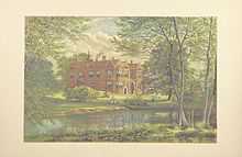
| Franks Hall |
Horton Kirby and South Darenth |
Mansion House |
1591 |
01952-08-01-00001 August 1952 |
TQ5550267822
51°23′17″N 0°14′00″E / 51.38814°N 0.233456°E / 51.38814; 0.233456 (Franks Hall) |
1238914 |
|
| St Clere |
Heaverham, Kemsing |
House |
Second quarter of 17th century |
01954-09-10-000010 September 1954 |
TQ5769259121
51°18′34″N 0°15′40″E / 51.309361°N 0.261052°E / 51.309361; 0.261052 (St Clere) |
1258564 |
|
| Church of St Bartholomew |
Otford |
Church |
Early Norman |
01954-09-10-000010 September 1954 |
TQ5285159308
51°18′44″N 0°11′30″E / 51.312361°N 0.191733°E / 51.312361; 0.191733 (Church of St Bartholomew) |
1273170 |
More images
|
| Church of St John the Baptist |
Penshurst |
Church |
1631 |
01954-09-10-000010 September 1954 |
TQ5273243859
51°10′25″N 0°11′00″E / 51.173578°N 0.183442°E / 51.173578; 0.183442 (Church of St John the Baptist) |
1243204 |
More images
|
| Penshurst Place |
Penshurst |
House |
1392 |
01954-09-10-000010 September 1954 |
TQ5274543976
51°10′29″N 0°11′01″E / 51.174626°N 0.183678°E / 51.174626; 0.183678 (Penshurst Place) |
1243169 |
More images
|
| South central entrance tower to Penshurst Place and wall abutting to east |
Penshurst Park, Penshurst |
Tower |
c. 1400 |
01975-01-16-000016 January 1975 |
TQ5277843948
51°10′28″N 0°11′03″E / 51.174366°N 0.184138°E / 51.174366; 0.184138 (South central entrance tower to Penshurst Place and wall abutting to east) |
1243044 |
More images
|
| Church of St Peter and St Paul |
Seal |
Church |
13th century |
01954-09-10-000010 September 1954 |
TQ5504756963
51°17′27″N 0°13′20″E / 51.290697°N 0.222198°E / 51.290697; 0.222198 (Church of St Peter and St Paul) |
1243497 |
|
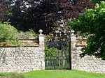
| Garden walls adjoining Knole House |
Knole Park |
Garden Wall |
|
01951-04-13-000013 April 1951 |
TQ5382754067
51°15′54″N 0°12′12″E / 51.265007°N 0.20347°E / 51.265007; 0.20347 (Garden walls adjoining Knole House) |
1204403 |
|
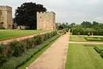
| Knole House |
Knole |
House |
Late 15th century |
01951-04-14-000014 April 1951 |
TQ5396854190
51°15′58″N 0°12′20″E / 51.266074°N 0.205542°E / 51.266074; 0.205542 (Knole House) |
1336390 |
More images
|
| Church of St Peter and St Paul |
Shoreham |
Church |
Norman |
01954-09-10-000010 September 1954 |
TQ5227961590
51°19′59″N 0°11′04″E / 51.333018°N 0.184506°E / 51.333018; 0.184506 (Church of St Peter and St Paul) |
1243786 |
More images
|
| Church of St Mary |
Sundridge, Sundridge with Ide Hill |
Church |
Norman |
01954-09-10-000010 September 1954 |
TQ4861854950
51°16′28″N 0°07′45″E / 51.274322°N 0.12923°E / 51.274322; 0.12923 (Church of St Mary) |
1272651 |
More images
|
| Combe Bank |
Sundridge, Sundridge with Ide Hill |
Villa/School |
Second quarter of 18th century |
01954-09-10-000010 September 1954 |
TQ4804455756
51°16′54″N 0°07′17″E / 51.281714°N 0.121341°E / 51.281714; 0.121341 (Combe Bank) |
1243769 |
|
| Stable block to north east of Combe Bank |
Sundridge, Sundridge with Ide Hill |
Courtyard |
Early 19th century |
01954-09-10-000010 September 1954 |
TQ4808355817
51°16′56″N 0°07′19″E / 51.282252°N 0.121925°E / 51.282252; 0.121925 (Stable block to north east of Combe Bank) |
1272637 |
|
| Church of Saint Edmund |
West Kingsdown |
Church |
Saxon |
01967-06-01-00001 June 1967 |
TQ5799263353
51°20′50″N 0°16′02″E / 51.347301°N 0.267228°E / 51.347301; 0.267228 (Church of Saint Edmund) |
1267477 |
More images
|
| Chartwell |
Chartwell, Westerham |
House |
16th century or 17th century |
01975-01-16-000016 January 1975 |
TQ4550451523
51°14′40″N 0°05′00″E / 51.24433°N 0.083227°E / 51.24433; 0.083227 (Chartwell) |
1272626 |
More images
|
| Quebec House |
Westerham |
House |
Possibly 1501 |
01954-09-10-000010 September 1954 |
TQ4492254053
51°16′02″N 0°04′33″E / 51.267213°N 0.075918°E / 51.267213; 0.075918 (Quebec House) |
1244133 |
|
| Squerryes Court |
Westerham |
House |
Early 18th century |
01954-09-10-000010 September 1954 |
TQ4411453406
51°15′42″N 0°03′51″E / 51.261603°N 0.064084°E / 51.261603; 0.064084 (Squerryes Court) |
1272592 |
More images |
.jpg)
.jpg)


.jpg)
.jpg)


.jpg)