| Name |
Location |
Type |
Completed | Date designated |
Grid ref.
Geo-coordinates |
Entry number | Image |
|
|
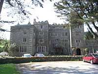
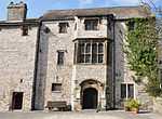
| Boringdon Hall |
Boringdon, City of Plymouth |
Great House |
Medieval |
01952-02-20-000020 February 1952 |
SX5393157780
50°24′06″N 4°03′24″W / 50.401696°N 4.056712°W / 50.401696; -4.056712 (Boringdon Hall) |
1330575 |
|
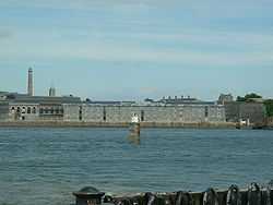
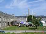
| Brewhouse Royal William Victualling Yard |
Stonehouse, Plymouth |
Ordnance Factory |
1929 |
01999-08-13-000013 August 1999 |
SX4601653553
50°21′42″N 4°09′59″W / 50.361687°N 4.166271°W / 50.361687; -4.166271 (Brewhouse Royal William Victualling Yard) |
1378528 |
|
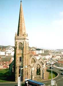
| Charles Church |
City of Plymouth |
Parish Church |
1640–1658 |
01954-01-25-000025 January 1954 |
SX4821654605
50°22′18″N 4°08′09″W / 50.371713°N 4.135788°W / 50.371713; -4.135788 (Charles Church) |
1130021 |
More images
|
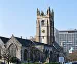
| Church of St Andrew |
City of Plymouth |
Parish Church |
Mid to Late 15th century |
01954-01-25-000025 January 1954 |
SX4792054395
50°22′11″N 4°08′24″W / 50.369749°N 4.139862°W / 50.369749; -4.139862 (Church of St Andrew) |
1130012 |
More images
|
| Clarence Steps South West Quay Wall and 2 Bollards Royal William Victualling Yard |
Stonehouse, Plymouth |
Gate |
1826–1831 |
01999-08-13-000013 August 1999 |
SX4595153405
50°21′37″N 4°10′02″W / 50.36034°N 4.167124°W / 50.36034; -4.167124 (Clarence Steps South West Quay Wall and 2 Bollards Royal William Victualling Yard) |
1378526 |

|
| Clarence Store Royal William Victualling Yard |
Stonehouse, Plymouth |
Naval Storehouse |
1829–1831 |
01999-08-13-000013 August 1999 |
SX4597153460
50°21′39″N 4°10′01″W / 50.360839°N 4.166865°W / 50.360839; -4.166865 (Clarence Store Royal William Victualling Yard) |
1378527 |
|
| Devonport Column |
Devonport, City of Plymouth |
Column |
1824 |
01954-01-25-000025 January 1954 |
SX4531654402
50°22′09″N 4°10′35″W / 50.369133°N 4.176454°W / 50.369133; -4.176454 (Devonport Column) |
1322008 |
|
| Devonport Guildhall and Attached Walls |
Devonport, City of Plymouth |
Wall |
1821–1822 |
01954-01-25-000025 January 1954 |
SX4532854385
50°22′08″N 4°10′35″W / 50.368983°N 4.176279°W / 50.368983; -4.176279 (Devonport Guildhall and Attached Walls) |
1322009 |
|
| Dock Basin Walls and 6 Associated Bollards, Royal William Victualling Yard |
Stonehouse, Plymouth |
Mooring Bollard |
1826–1832 |
01999-08-13-000013 August 1999 |
SX4612253626
50°21′45″N 4°09′53″W / 50.362371°N 4.164812°W / 50.362371; -4.164812 (Dock Basin Walls and 6 Associated Bollards, Royal William Victualling Yard) |
1378529 |
|
| East Ropery, Formerly Spinning House (s 132), and Attached Retaining Walls |
Devonport Dockyard, City of Plymouth |
Fireproof Factory |
Rebuilt 1813–1817 |
01999-08-13-000013 August 1999 |
SX4518854215
50°22′03″N 4°10′41″W / 50.367419°N 4.178176°W / 50.367419; -4.178176 (East Ropery, Formerly Spinning House (s 132), and Attached Retaining Walls) |
1388400 |
|
| Main Gate, Royal William Victualling Yard |
Stonehouse, Plymouth |
Gate |
1829–1833 |
01999-08-13-000013 August 1999 |
SX4626053635
50°21′45″N 4°09′46″W / 50.362487°N 4.162877°W / 50.362487; -4.162877 (Main Gate, Royal William Victualling Yard) |
1378530 |
|
| Melville, Royal William Victualling Yard |
Stonehouse, Plymouth |
Fireproof Building |
1828–1832 |
01999-08-13-000013 August 1999 |
SX4616253536
50°21′42″N 4°09′51″W / 50.361572°N 4.164213°W / 50.361572; -4.164213 (Melville, Royal William Victualling Yard) |
1378531 |
|
| Mills and Bakery, Royal William Victualling Yard |
Stonehouse, Plymouth |
Bakery |
1830–1834 |
01999-08-13-000013 August 1999 |
SX4618553628
50°21′45″N 4°09′50″W / 50.362405°N 4.163928°W / 50.362405; -4.163928 (Mills and Bakery, Royal William Victualling Yard) |
1378532 |
|
| North East Quay Wall and 2 Bollards, Royal William Victualling Yard |
Stonehouse, Plymouth |
Wall |
1826–1831 |
01999-08-13-000013 August 1999 |
SX4612353659
50°21′46″N 4°09′53″W / 50.362667°N 4.164811°W / 50.362667; -4.164811 (North East Quay Wall and 2 Bollards, Royal William Victualling Yard) |
1378533 |
|
| Oddfellows Hall |
Devonport, City of Plymouth |
Oddfellows Hall |
1823 |
01954-01-21-000021 January 1954 |
SX4538054413
50°22′09″N 4°10′32″W / 50.369248°N 4.17556°W / 50.369248; -4.17556 (Oddfellows Hall) |
1322006 |
|
| Old Cooperage Royal William Victualling Yard |
Stonehouse, Plymouth |
Ordnance Factory |
1891 |
01999-08-13-000013 August 1999 |
SX4604253476
50°21′40″N 4°09′57″W / 50.361002°N 4.165874°W / 50.361002; -4.165874 (Old Cooperage Royal William Victualling Yard) |
1378536 |
|
| Plympton House |
Plympton St Maurice |
Country House |
1952 |
01952-04-23-000023 April 1952 |
SX5466055896
50°23′06″N 4°02′45″W / 50.384944°N 4.045732°W / 50.384944; -4.045732 (Plympton House) |
1113363 |
|
| Police Buildings Royal William Victualling Yard |
Stonehouse, Plymouth |
House |
Before 1891 |
01999-08-13-000013 August 1999 |
SX4625653615
50°21′44″N 4°09′47″W / 50.362307°N 4.162925°W / 50.362307; -4.162925 (Police Buildings Royal William Victualling Yard) |
1378534 |
|
| Prysten House |
City of Plymouth |
Merchants House |
c. 1498 |
01954-01-25-000025 January 1954 |
SX4792354371
50°22′10″N 4°08′23″W / 50.369534°N 4.139811°W / 50.369534; -4.139811 (Prysten House) |
1067152 |
More images
|
| Royal Albert Bridge (that Part in Plymouth Civil Parish) |
St Budeaux, City of Plymouth |
Railway Bridge |
1857–1859 |
01954-01-25-000025 January 1954 |
SX4366258711
50°24′27″N 4°12′05″W / 50.407418°N 4.201487°W / 50.407418; -4.201487 (Royal Albert Bridge (that Part in Plymouth Civil Parish)) |
1386355 |
|
| Royal Albert Bridge and 17 Approach Spans |
Riverside |
Suspension Bridge |
1848 |
01952-01-17-000017 January 1952 |
SX4351558740
50°24′28″N 4°12′13″W / 50.40764°N 4.203566°W / 50.40764; -4.203566 (Royal Albert Bridge and 17 Approach Spans) |
1159292 |
|
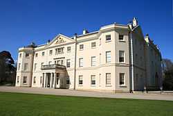
| Saltram House |
Saltram Park, City of Plymouth |
Country House |
18th century |
01952-04-23-000023 April 1952 |
SX5203855605
50°22′54″N 4°04′57″W / 50.381675°N 4.082474°W / 50.381675; -4.082474 (Saltram House) |
1386230 |
More images
|
| Slaughterhouse and Attached Yard Wall, Royal William Victualling Yard |
Stonehouse, Plymouth |
Wall |
1830–1831 |
01999-08-13-000013 August 1999 |
SX4620853669
50°21′46″N 4°09′49″W / 50.362779°N 4.163621°W / 50.362779; -4.163621 (Slaughterhouse and Attached Yard Wall, Royal William Victualling Yard) |
1378535 |
|
| The Quadrangle (n 173-177, 186-191, 203) |
Devonport Dockyard, City of Plymouth |
Boiler House |
1852–1861 |
01999-08-13-000013 August 1999 |
SX4490255661
50°22′49″N 4°10′58″W / 50.380338°N 4.182791°W / 50.380338; -4.182791 (The Quadrangle (n 173-177, 186-191, 203)) |
1378566 |
|
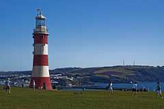
| Smeaton's Tower |
Hoe, City of Plymouth |
Lighthouse |
1759 |
01954-01-25-000025 January 1954 |
SX4776253799
50°21′52″N 4°08′31″W / 50.364352°N 4.141841°W / 50.364352; -4.141841 (Smeaton's Tower) |
1386470 |
More images |