| Name |
Location |
Type |
Completed | Date designated |
Grid ref.
Geo-coordinates |
Entry number | Image |
|
|
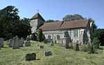
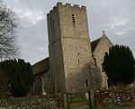
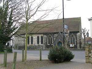
| Church of St Anthony the Martyr |
Alkham, Dover (district) |
Church |
c. 1200 |
01962-08-22-000022 August 1962 |
TR2554442365
51°08′10″N 1°13′21″E / 51.136113°N 1.222597°E / 51.136113; 1.222597 (Church of St Anthony the Martyr) |
1084358 |
More images
|
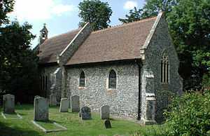
| Church of St Nicholas |
Ash |
Parish Church |
c. 1190 |
01963-10-11-000011 October 1963 |
TR2875958384
51°16′43″N 1°16′43″E / 51.278645°N 1.278679°E / 51.278645; 1.278679 (Church of St Nicholas) |
1363280 |
More images
|
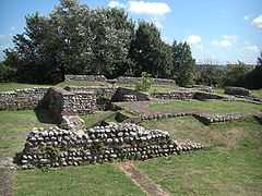
| Richborough Castle |
Richborough, Ash |
Settlement |
AD43 |
01987-11-26-000026 November 1987 |
TR3244460253
51°17′38″N 1°19′57″E / 51.293932°N 1.332636°E / 51.293932; 1.332636 (Richborough Castle) |
1363256 |
More images
|
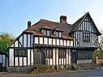
| Ratling Court |
Ratling, Aylesham |
House |
Late 15th century |
01963-10-11-000011 October 1963 |
TR2398153690
51°14′18″N 1°12′26″E / 51.238401°N 1.207349°E / 51.238401; 1.207349 (Ratling Court) |
1363218 |

|
| Church of St Mary |
Capel-le-Ferne |
Parish Church |
now redundant |
01962-08-22-000022 August 1962 |
TR2571140018
51°06′54″N 1°13′25″E / 51.114976°N 1.223512°E / 51.114976; 1.223512 (Church of St Mary) |
1070047 |
More images
|
| Church of St Mary in Castro |
Dover Castle, Dover |
Church |
18th century |
01974-03-07-00007 March 1974 |
TR3262941822
51°07′42″N 1°19′24″E / 51.128407°N 1.323342°E / 51.128407; 1.323342 (Church of St Mary in Castro) |
1070328 |
More images
|
| Dover Castle |
Dover Castle, Dover |
Castle |
c. 1155 |
01974-03-07-00007 March 1974 |
TR3247941938
51°07′46″N 1°19′17″E / 51.129509°N 1.321277°E / 51.129509; 1.321277 (Dover Castle) |
1070326 |
More images
|
| The Roman Pharos |
Dover Castle, Dover |
Tower |
AD46 |
01974-03-07-00007 March 1974 |
TR3260441815
51°07′42″N 1°19′23″E / 51.128354°N 1.322981°E / 51.128354; 1.322981 (The Roman Pharos) |
1258537 |
More images
|
| Church of St Mary the Virgin |
Eastry, Dover |
Parish Church |
12th century |
01963-10-11-000011 October 1963 |
TR3111254777
51°14′43″N 1°18′36″E / 51.245317°N 1.310028°E / 51.245317; 1.310028 (Church of St Mary the Virgin) |
1363287 |
More images
|
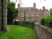
| Eastry Court |
Eastry |
Archbishops Palace |
16th century |
01952-10-13-000013 October 1952 |
TR3112554816
51°14′44″N 1°18′37″E / 51.245662°N 1.310239°E / 51.245662; 1.310239 (Eastry Court) |
1366610 |
|
| Fairfield House |
Eastry |
Cross Wing House |
Early 15th century |
01963-10-11-000011 October 1963 |
TR3093954579
51°14′37″N 1°18′27″E / 51.243609°N 1.307426°E / 51.243609; 1.307426 (Fairfield House) |
1070186 |
|
| Church of St Nicholas |
Barfrestone, Eythorne |
Church |
c. 1180 |
01963-10-11-000011 October 1963 |
TR2642550146
51°12′20″N 1°14′24″E / 51.20562°N 1.240065°E / 51.20562; 1.240065 (Church of St Nicholas) |
1070306 |
More images
|
| Church of St Clement |
Knowlton, Goodnestone |
Parish Church |
19th century |
01963-10-11-000011 October 1963 |
TR2816053353
51°14′01″N 1°16′01″E / 51.233721°N 1.266899°E / 51.233721; 1.266899 (Church of St Clement) |
1111748 |
More images
|
| Church of the Holy Cross |
Goodnestone |
Parish Church |
Late 12th century |
01963-10-11-000011 October 1963 |
TR2547454583
51°14′45″N 1°13′45″E / 51.24583°N 1.229263°E / 51.24583; 1.229263 (Church of the Holy Cross) |
1070258 |
More images
|
| Knowlton Court |
Knowlton, Goodnestone |
House |
1585 |
01952-10-13-000013 October 1952 |
TR2810953319
51°14′00″N 1°15′58″E / 51.233436°N 1.266148°E / 51.233436; 1.266148 (Knowlton Court) |
1336977 |
|
| Church of St Lawrence |
Church Hougham, Hougham Without |
Parish Church |
12th century |
01962-08-22-000022 August 1962 |
TR2782739972
51°06′49″N 1°15′13″E / 51.113727°N 1.253664°E / 51.113727; 1.253664 (Church of St Lawrence) |
1070024 |
|
| Church of St Mary |
Nonington |
Parish Church |
Late 13th century |
01963-10-11-000011 October 1963 |
TR2530752348
51°13′33″N 1°13′32″E / 51.225831°N 1.22547°E / 51.225831; 1.22547 (Church of St Mary) |
1070241 |
More images
|
| St Albans Court |
Nonington |
Country House |
1875-78 |
01952-10-13-000013 October 1952 |
TR2635752640
51°13′41″N 1°14′26″E / 51.228037°N 1.240666°E / 51.228037; 1.240666 (St Albans Court) |
1070242 |
|
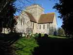
| Church of St Augustine |
Northbourne |
Parish Church |
12th century |
01963-10-11-000011 October 1963 |
TR3336452233
51°13′18″N 1°20′26″E / 51.221564°N 1.340581°E / 51.221564; 1.340581 (Church of St Augustine) |
1264324 |
More images
|
| Church of St Mildred |
Preston |
Library |
Early 13th century |
01963-10-11-000011 October 1963 |
TR2439160404
51°17′55″N 1°13′03″E / 51.298516°N 1.217423°E / 51.298516; 1.217423 (Church of St Mildred) |
1376652 |
More images
|
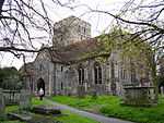
| Church of St Nicholas |
Ringwould with Kingsdown |
Parish Church |
12th century |
01966-08-22-000022 August 1966 |
TR3597448303
51°11′07″N 1°22′31″E / 51.185215°N 1.375307°E / 51.185215; 1.375307 (Church of St Nicholas) |
1070060 |
More images
|
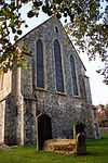
| Chapel of St Bartholomew |
Stone Cross, Sandwich |
Chapel |
Early English |
01950-05-19-000019 May 1950 |
TR3304057506
51°16′09″N 1°20′22″E / 51.26903°N 1.339379°E / 51.26903; 1.339379 (Chapel of St Bartholomew) |
1343722 |
|
| Church of St Clement |
Sandwich |
Parish Church |
Latter half of 12th century |
01950-05-19-000019 May 1950 |
TR3328658006
51°16′24″N 1°20′36″E / 51.273418°N 1.343225°E / 51.273418; 1.343225 (Church of St Clement) |
1343695 |
More images
|
| Church of St Mary |
Sandwich |
Church |
Norman rebuilding |
01950-05-19-000019 May 1950 |
TR3295158417
51°16′38″N 1°20′19″E / 51.277244°N 1.338699°E / 51.277244; 1.338699 (Church of St Mary) |
1069541 |
More images
|
| Church of St Peter |
Sandwich |
Church |
1948-73 |
01950-05-19-000019 May 1950 |
TR3307458165
51°16′30″N 1°20′25″E / 51.274932°N 1.340295°E / 51.274932; 1.340295 (Church of St Peter) |
1343813 |
More images
|
| Fisher Gate |
Sandwich |
Town Gate |
1384 |
01970-04-29-000029 April 1970 |
TR3328258194
51°16′30″N 1°20′36″E / 51.275107°N 1.34329°E / 51.275107; 1.34329 (Fisher Gate) |
1069601 |
More images
|
| The Barbican |
Sandwich |
Gatehouse |
1950 |
01950-05-19-000019 May 1950 |
TR3318058258
51°16′33″N 1°20′31″E / 51.275723°N 1.341872°E / 51.275723; 1.341872 (The Barbican) |
1069655 |
|
| The Salutation |
Sandwich |
Manor House |
1912 |
01950-05-19-000019 May 1950 |
TR3336658124
51°16′28″N 1°20′40″E / 51.274444°N 1.344447°E / 51.274444; 1.344447 (The Salutation) |
1069643 |
More images
|
| Church of St Pancras |
Coldred, Shepherdswell with Coldred |
Parish Church |
Saxon |
01962-08-22-000022 August 1962 |
TR2744047594
51°10′56″N 1°15′11″E / 51.182307°N 1.252955°E / 51.182307; 1.252955 (Church of St Pancras) |
1069988 |
More images
|
| The Belvedere |
Waldershare Park, Shepherdswell with Coldred |
Belvedere |
1725-7 |
01962-08-22-000022 August 1962 |
TR2816047499
51°10′52″N 1°15′47″E / 51.181168°N 1.263179°E / 51.181168; 1.263179 (The Belvedere) |
1051607 |
|
| Waldershare Park |
Waldershare Park, Shepherdswell with Coldred |
Country House/Apartments |
1962 |
01962-08-22-000022 August 1962 |
TR2895347999
51°11′07″N 1°16′29″E / 51.185339°N 1.274824°E / 51.185339; 1.274824 (Waldershare Park) |
1069998 |
|
| Waldershare Park |
Waldershare Park, Tilmanstone, Shepherdswell with Coldred |
Flats |
1987 |
01952-10-13-000013 October 1952 |
TR2896348018
51°11′08″N 1°16′30″E / 51.185506°N 1.274979°E / 51.185506; 1.274979 (Waldershare Park) |
1247724 |
|
| Church of St Margaret |
St Margaret's at Cliffe |
Parish Church |
Earlier |
01966-08-22-000022 August 1966 |
TR3587744771
51°09′13″N 1°22′18″E / 51.153551°N 1.371606°E / 51.153551; 1.371606 (Church of St Margaret) |
1101743 |
More images
|
| Church of St James |
Staple |
Parish Church |
12th-century origins |
01963-10-11-000011 October 1963 |
TR2693656641
51°15′49″N 1°15′05″E / 51.263726°N 1.251479°E / 51.263726; 1.251479 (Church of St James) |
1070137 |
More images
|
| Church of All Saints |
West Stourmouth, Stourmouth |
Parish Church |
Saxon |
01963-10-11-000011 October 1963 |
TR2561662880
51°19′13″N 1°14′12″E / 51.32026°N 1.23653°E / 51.32026; 1.23653 (Church of All Saints) |
1203363 |
More images
|
| Church of St Andrew |
Tilmanstone |
Parish Church |
12th century |
01963-10-11-000011 October 1963 |
TR3021251470
51°12′58″N 1°17′42″E / 51.215994°N 1.295033°E / 51.215994; 1.295033 (Church of St Andrew) |
1247778 |
More images
|
| Canon Cottage & the Old Canonry |
Wingham |
Clergy House |
1283 onwards |
01952-10-13-000013 October 1952 |
TR2424657401
51°16′18″N 1°12′48″E / 51.271613°N 1.213463°E / 51.271613; 1.213463 (Canon Cottage & the Old Canonry) |
1281551 |
More images
|
| Church of St Mary |
Wingham, Dover |
Collegiate Church |
1282 to 1547 |
01963-10-11-000011 October 1963 |
TR2421257474
51°16′20″N 1°12′47″E / 51.272282°N 1.213022°E / 51.272282; 1.213022 (Church of St Mary) |
1070091 |
More images |